


Garmin G900X Pilot’s Guide
190-00726-00 Rev. J
472
HAZARD AVOIDANCE
SY
STEM
O
VER
VIEW
FLIGHT
INSTRUMENTS
EIS
AUDIO P
ANEL
& CNS
FLIGHT
MANA
GEMENT
HAZARD
AV
OID
ANCE
AFCS
ADDITIONAL FEA
TURES
APPENDICES
INDEX
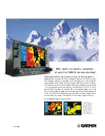
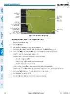
TRAFFIC MAP PAGE
The Traffic Map Page shows surrounding TAS traffic data in relation to the aircraft’s current position and
altitude, without basemap clutter. Aircraft orientation is always heading up unless there is no valid heading.
Map range is adjustable with the
RANGE
Knob
, as indicated by the map range rings.
The traffic mode and altitude display mode are annunciated in the upper left corner of the page.
Figure 6-168 Traffic Map Page
Altitude
Mode
Proximity Traffic,
900’ Above,
Level, Flight ID
Displayed
“No Bearing”
Traffic (Bearing
Undetermined),
Distance 4.0
nm, 500’ Above,
Climbing
Non-Threat Traffic,
2500’ Above,
Descending
Traffic
Advisory Off-
Scale, 400’
Below, Level
Traffic Display
Range Rings
Non-Threat
Traffic,
Altitude Not
Reported
Non-Threat
Traffic with
ADS-B
Directional
Information,
1000’ Above,
Level
Traffic Advisory with ADS-B Directional
Information, 500’ Below, Climbing
Altitude
Mode
Displaying traffic on the Traffic Map Page:
1)
Turn the large
FMS
Knob to select the Map Page Group.
2)
Turn the small
FMS
Knob
to select the Traffic Map Page.
3)
Press the
OPERATE
Softkey to begin displaying traffic. OPERATING is displayed in the Traffic mode field.
4)
Press the
STANDBY
Softkey to place the system in the Standby mode. STANDBY is displayed in the Traffic mode
field.
5)
Turn the
RANGE
Knob clockwise to display a larger area or counter-clockwise to display a smaller area.
Содержание G900X
Страница 1: ...G900X Integrated Flight Deck Pilot s Guide ...
Страница 2: ......
Страница 10: ...Garmin G900X Pilot s Guide 190 00726 00 Rev J vi WARNINGS CAUTIONS AND NOTES Blank Page ...
Страница 16: ...Garmin G900X Pilot s Guide 190 00726 00 Rev J xii TABLE OF CONTENTS Blank Page ...
Страница 707: ......