


Garmin G900X Pilot’s Guide
190-00726-00 Rev. J
422
HAZARD AVOIDANCE
SY
STEM
O
VER
VIEW
FLIGHT
INSTRUMENTS
EIS
AUDIO P
ANEL
& CNS
FLIGHT
MANA
GEMENT
HAZARD
AV
OID
ANCE
AFCS
ADDITIONAL FEA
TURES
APPENDICES
INDEX
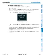
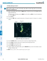
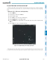
Manually clearing Stormscope data on the Navigation Map:
1)
Press the
MENU
Key.
2)
Select ‘Clear Stormscope
®
Lightning’ (Figure 6-117).
3)
Press the
ENT
Key.
Figure 6-117 Navigation Map Page Options Menu
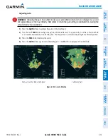
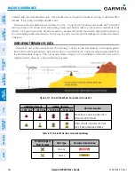
ZOOM RANGE ON THE NAVIGATION MAP
Stormscope lightning data can be displayed up to 800 nm zoom range (in North up mode) on the Navigation
Map Page.
However, in the track up mode at the 500 nm range, a portion of Stormscope lightning data
can be behind the aircraft and therefore not visible on the Navigation Map
. Since the range for Stormscope
data is 400 nm diameter total (200 nm in front and 200 nm behind), the 500 nm range in North up mode
shows all the data.
At a map range of less than 30 nm, Stormscope lightning data is not displayed, but can still be present.
The maximum zoom range can also be set on the Navigation Map.
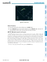
Selecting a Stormscope range on the Navigation Map:
1)
Press the
MENU
Key.
2)
Select ‘MAP SETUP’.
3)
Select the ‘Weather’ group.
4)
Press the
ENT
Key.
5)
Turn the
large FMS
Knob to select ‘STRMSCP SMBL’.
6)
Turn the
small FMS
Knob to select the maximum display range.
7)
Press the
ENT
Key.
8)
Press the
FMS
Knob to return to the Navigation Map Page.
To change the display range on the Navigation Map Page, turn the
RANGE
Knob clockwise to zoom out or
counter-clockwise to zoom in.
Содержание G900X
Страница 1: ...G900X Integrated Flight Deck Pilot s Guide ...
Страница 2: ......
Страница 10: ...Garmin G900X Pilot s Guide 190 00726 00 Rev J vi WARNINGS CAUTIONS AND NOTES Blank Page ...
Страница 16: ...Garmin G900X Pilot s Guide 190 00726 00 Rev J xii TABLE OF CONTENTS Blank Page ...
Страница 707: ......