background image

cf

 Que

1620

The Hard Buttons

Using the Arrow Button to access cf Que features

All Pocket PC’s have a four or five position button used for scrolling lists, etc. 

For our purposes we will refer to this button as the 

Arrow

 button. You can use this 

button to operate many of the cf Que navigation features.

To change the Map Scale on the Map Page:

1. With the Map Page displayed, press the 

Top 

or

Bottom

of the Arrow   

  Button to increase or decrease the map scale. Hold the button down to  
  zoom the scale. Observe the map scale window in the lower left corner  
  of the map to determine the desired scale.

To scroll any list:

1. With an entry on the list highlighted, press the top or bottom of the  
 Arrow 

Button.

Using the Jog Button to change map scale or scroll lists

Many Pocket PC’s have a special button on the side of the device used for scroll-

ing lists, etc. For our purposes we will refer to this button as the 

Jog Button

. You 

can use this button to not only scroll lists but change the map scale up or down 
when viewing the Map Page. Note that for some lists in the Que application, an item 
must be highlighted before you can scroll the list.

To change the Map Scale on the Map Page:

1.  With the Map Page displayed, press or rotate 

Up

or

Down

to increase

  or decrease the map scale.

To scroll a list:

1. With the list displayed and an item highlighted, move the button 

Up

or

Down

to scroll the list.

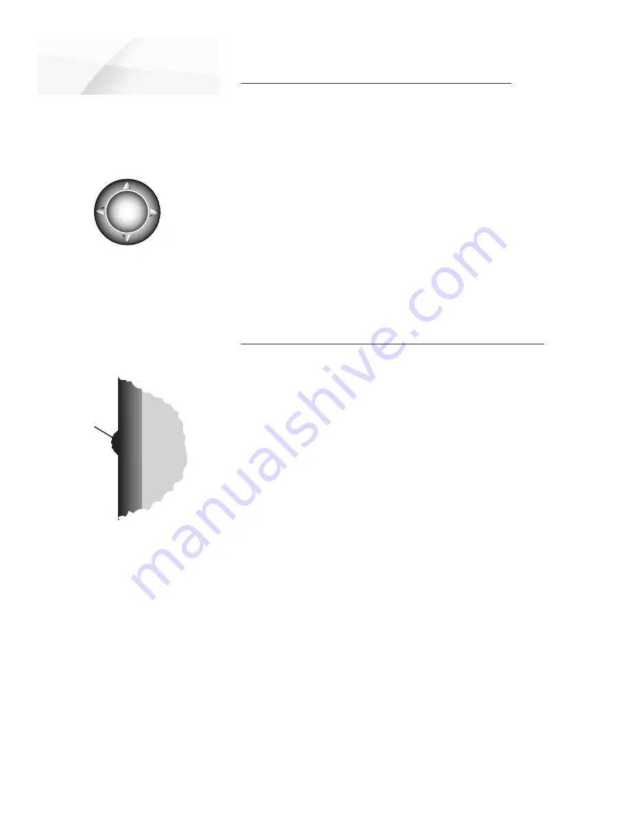
(Graphic representation, may not 

exactly resemble the button on your 

device.)

    Up

Right

    Down

   Left

The Arrow Button

Hardware Mapping

Jog
Button

Side of 
device.

The Jog Button

-32-

Содержание cf Que 1620

Страница 1: ...cf Que 1620 cf Que 1620 GPS navigator module applications guide...

Страница 2: ...the Garmin web site www garmin com for current updates and supplemental information concerning the use and operation of this and other Garmin products Garmin and MapSource are registered trademarks an...

Страница 3: ...er rights to the Product shall remain with us You must reproduce any copyright or other notice marked on the Product on all copies you make 2 YOU MAY a install and use one copy of the Product on a sin...

Страница 4: ...PPLY WHETHER OR NOT THE ALLEGED BREACH OR DEFAULT IS A BREACH OF A FUNDAMENTAL CONDITION OR TERM OR A FUNDA MENTAL BREACH SOME STATES COUNTRIES DO NOT ALLOW THE EXCLU SION OR LIMITATION OF LIABILITY F...

Страница 5: ...are designed to provide more reasonable protection against harmful interference in a residential installation and are more stringent than outdoor requirements Operation of this device is subject to th...

Страница 6: ...he cf Que 1620 installed to place and secure the device so that it will not interfere with the vehicle operating controls and safety devices obstruct the driver s view of driving conditions or cause d...

Страница 7: ...36 37 Troubleshooting Guide 38 Accessories 39 Index 40 41 Table of Contents Chapter 1 Introduction i vi Software License Agreement i ii FCC Compliance Information iii Warnings and Precautions iii iv T...

Страница 8: ...nstal lation CD About the Manuals Editor s Note The above manuals and guides were created using the cf Que and Que operat ing software installed on a Pocket PC equipped with popular features and opera...

Страница 9: ...isplay the Programs List with the Garmin Que icon Tap the Garmin Que icon to display an introduction page and then the Map Page and you re on your way to navigating Helpful Hint To shorten the process...

Страница 10: ...Satellites message will display at the top of the page When your location has been determined a 3D GPS Location message replaces the original message After you begin moving it changes to display the n...

Страница 11: ...the tool bar displays the Details Page with either an address description or latitude and longitude coordinates for your current location or a map point defined by the Map Pointer Tapping the stylus o...

Страница 12: ...age Data Fields The Garmin Que software allows you to customize the display of Map Page Data Fields You can customize the background and text colors from black to white or create a transparent backgro...

Страница 13: ...me field location To determine the arrangement of the Data Fields 1 Tap and Hold anywhere on a data eld to display the Customize window then tap the window to display the tabbed Setup Menu 2 Tap the R...

Страница 14: ...Factory default settings currently operate the application For instructions on using System Setup see page 10 Find This feature provides you with lists by category of locations contained in the detai...

Страница 15: ...activate Auto Zoom Tap Auto Zoom to activate this feature which automatically scales the map to display both your current location and the next turn in a route during active navigation Detailed Maps T...

Страница 16: ...rom Off Small Medium and Large options for display of each listed map feature To set the Maximum Zoom 1 For Maximum Zoom select from OFF AUTO or from an incremental scale of 120 feet to 800 miles 2 Re...

Страница 17: ...ze for Navaids Spot Soundings and Tide Stations 1 Tap the Marine tab from the Map Setup Pages 2 Select the text size for each type of map item To set the Maximum Zoom level 1 For Maximum Zoom select f...

Страница 18: ...updates on the status of the GPS signal reception select Guidance and Status 2 To receive direction voice prompts only select Route Guidance 3 To receive guidance only when desired by pressing a hard...

Страница 19: ...uttons on the unit to perform specific Que Application functions To map system features to device hard buttons Refer to page 33 for detailed instructions Language Settings You can choose a specific la...

Страница 20: ...on Near Map Pointer By Name Near Other and Near a Previously Selected Item Near Other selects a new item to replace the Near previously selected item To further refine your search you can select a sub...

Страница 21: ...to display a ve option menu 6 Tap Details to view the Details Page which displays the city on the map and provides a brief description below the map Tap the Route To It button to create a route to th...

Страница 22: ...ted state or province Select a city If you tap the City eld rst the Region eld will be hidden 5 Enter the street address next 6 Tap the Street eld to display the Street Name dialog page Enter the rst...

Страница 23: ...y a list of cities in the selected state or province Select a city If you tap the City eld rst the Region eld will be hidden 5 Tap the rst Street eld to display the Street Name dialog page Enter the r...

Страница 24: ...ect to display the re ned list of items related to that subject 5 With the list displayed highlight a single Point of Interest item 6 When you tap Details an information page displays showing a locati...

Страница 25: ...create a route to the city from your current location 6 To create a route without rst viewing the Details Page tap Route To It from the drop down menu 7 To search for other map items near this city ta...

Страница 26: ...as a waypoint 1 With the Map Page displayed use the stylus to tap the desired loca tion on the map which causes the Map Pointer white arrow to display If the point on the map has descriptive informat...

Страница 27: ...a map symbol to a waypoint 1 Adjacent to the Altitude eld is a map symbol box Tap the box to display the Map Symbols List and select the desired symbol for your waypoint To change the location of a w...

Страница 28: ...ocation coordinates display at the top of the left hand column On the right the date and time displays along with your approximate elevation and if you are moving your current speed displays as well W...

Страница 29: ...o those previously mentioned A route cannot be calculated unless the GPS receiver has determined your current location and you have selected a destination Check the GPS status message at the top of th...

Страница 30: ...ss data 4 Tap Search to display the best matches 5 Highlight your choice and hold the stylus in place to display the drop down menu 6 Select Route To It to begin the route calculation You can also tap...

Страница 31: ...bar 2 When the Route Menu displays tap the Turns icon to display the Turns Page Each turn on the route is displayed on this page Each turn entry provides written instructions the distance to the next...

Страница 32: ...cket PC To set Routing Preferences 1 On the Routing preferences page under Route Preference tap Faster Time Shorter Distance Off Road or Custom If you want this option to display every time you begin...

Страница 33: ...t Tap the box next to any item on the list to place an active check in the box 6 Tap and hold the stylus on a selected Avoid Roads item to View Edit or Delete Tap Measure from Pointer icon Tap Start P...

Страница 34: ...create a route to your Home Point tap the Route icon on the tool bar and then the Route To Home icon on the Routes Menu 4 To change the Home Point tap the Home tab of the Route Preferences Pages and r...

Страница 35: ...want to avoid then tap the turn description and then OK to recalculate the route to avoid the turn To Detour a specified section of a roadway on a Route Tap the Avoidance icon in the upper right corne...

Страница 36: ...me it is automatically given a numeral identity You can personalize it by renaming to a title of your choice 4 The next two elds are Track Start Time and Track End Time Tap each eld to select a beginn...

Страница 37: ...If you have previously iden ti ed a map location with the Pointer then Point will also be available as a choice Make your selection and tap OK to return the Sun and Moon Page To control Sun and Moon g...

Страница 38: ...e map and observe the direction and distance in the eld above the Tool Bar To Measure Distance between two points on the map 1 Adjust the map scale to include the points you want to measure between Se...

Страница 39: ...distance for all trips Menu options allow you to Reset the Computer Reset the Maximum Speed and Reset the Odometer To access the Trip Computer 1 From the Map Page open the Main Menu and then tap Trip...

Страница 40: ...the Arrow Button Using the Jog Button to change map scale or scroll lists Many Pocket PC s have a special button on the side of the device used for scroll ing lists etc For our purposes we will refer...

Страница 41: ...when the Que applica tion is displayed then tap the Un map when app not visible option to place a check mark in the box 6 If you want to use the Arrow Button to cycle from page to page tap the Left a...

Страница 42: ...ng To cf Que window appears and then states The data was successfully saved when transfer is complete 6 Click OK to nish Save To cf Que Window Use the Map Tool to select maps for transfer to the cf Qu...

Страница 43: ...5 An Opening from cf Que window will display and then signal Data Successfully Saved when all waypoints have been opened Click OK to transfer the waypoints to the MapSource Waypoints eld 6 If you hav...

Страница 44: ...y Select and City Navigator CD ROM s which provide street level detail addresses listings of nearest restaurant hotels ATMs and more Accepts most other MapSource map data as well as U S Topos and Mari...

Страница 45: ...The cf Que is not waterproof and exposure to excessive amounts of liquid may damage the unit beyond repair Storage When not in use the cf Que should be stored in a cool dry place Storage temperatures...

Страница 46: ...ed Maps Don t Support Routing These maps are not the type used for auto routing Select maps designed for auto routing Too Many Maps on Data Card The map sets you are trying to load are too Check the s...

Страница 47: ...ts Replacement Dash Base Mount Includes one temporary and one permanent adhesive disk Allows transfer of the PDA Mount to another vehicle Replacement Portable Dash Friction Mount Non skid bag type bas...

Страница 48: ...Waypoint 19 Details Map 7 Details Page 13 Detailed Maps Setup 7 Detours Adding 27 Distance Measuring 30 E Ending a Route Stop Navigating 21 Editing Via Points on a Route 21 26 Waypoints 19 Elevation...

Страница 49: ...atus 1 20 Recently Found Places 12 Renaming Waypoints 19 Resetting Trip Information 31 Resume Route Navigation 21 Route Preferences 24 Routes Page 21 S Satellite Information Page 20 Saving Routes 23 S...

Страница 50: ...ernational Inc 1200 East 151st Street Olathe Kansas 66062 U S A Garmin Europe Ltd Unit 5 The Quadrangle Abbey Park Industrial Estate Romsey SO51 9DL U K Garmin Corporation No 68 Jangshu 2nd Road Shijr...

Отзывы: