Autopilot Operation
SkyView Classic Pilot’s User Guide –
Revision Z
8-26
4.
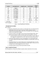
Set the desired heading and altitude bugs. This can be done on the ground prior to
take-off.
5.
Altitude hold mode will automatically be armed at the altitude bug value. Adjust the
rate of climb or descent with the NOSE UP / DN buttons in the Pitch Menu or adjust the
vertical speed bug.
6.
Select HDG or TRK from the Roll Menu to proceed in the desired direction.
Change Altitude with Vertical Speed
1.
Adjust the altitude bug to the new desired altitude.
2.
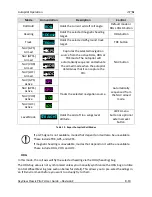
If you weren’t already climbing or descending, initiate the climb or descent with the
NOSE UP / DN buttons (either in the PITCH menu or on the Autopilot Control Panel) or
adjust the vertical speed bug.
3.
This automatically engages VS->ALT mode.
Change Altitude with Indicated Airspeed
1.
Adjust the altitude bug to the new desired altitude.
2.
Press the IAS button on the Pitch Menu or the Autopilot Control Panel.
3.
If you weren’t a
lready climbing or descending, initiate a climb or descent with the NOSE
UP / DN buttons (either in the PITCH menu or on the Autopilot Control Panel) to adjust
the autopilot’s target airspeed. Or adjust the airspeed bug or adjust the aircraft’s power.
Track a Navigation Source
1.
This procedure is identical whether you are tracking an enroute navigation source (GPS
or VOR) or a non-precision approach (GPS, VOR or LOC).
2.
Select a navigation source on the HSI (MAIN MENU > AUTOPILOT > HSI SRC).
3.
The navigation source must be providing valid course and deviation information.
4.
Press the NAV button in the Roll Menu.
5.
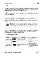
If the CDI is already near-centered NAV mode will immediately become active.
Otherwise NAV mode will arm.
6.
If NAV
mode is armed, adjust the current mode’s t
arget (heading, track or roll) to
establish the desired intercept with the navigation source.
7.
NAV mode will become active once the navigation source CDI can be captured by the
autopilot.
Precision Approach
1.
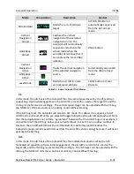
Select a navigation source on the on the HSI (MAIN MENU > AUTOPILOT > HSI SRC).
a.
The external navigation source must be providing valid course and deviation
information.


