background image

Chapter 8-12 

CR44/54 Waypoint / route menu

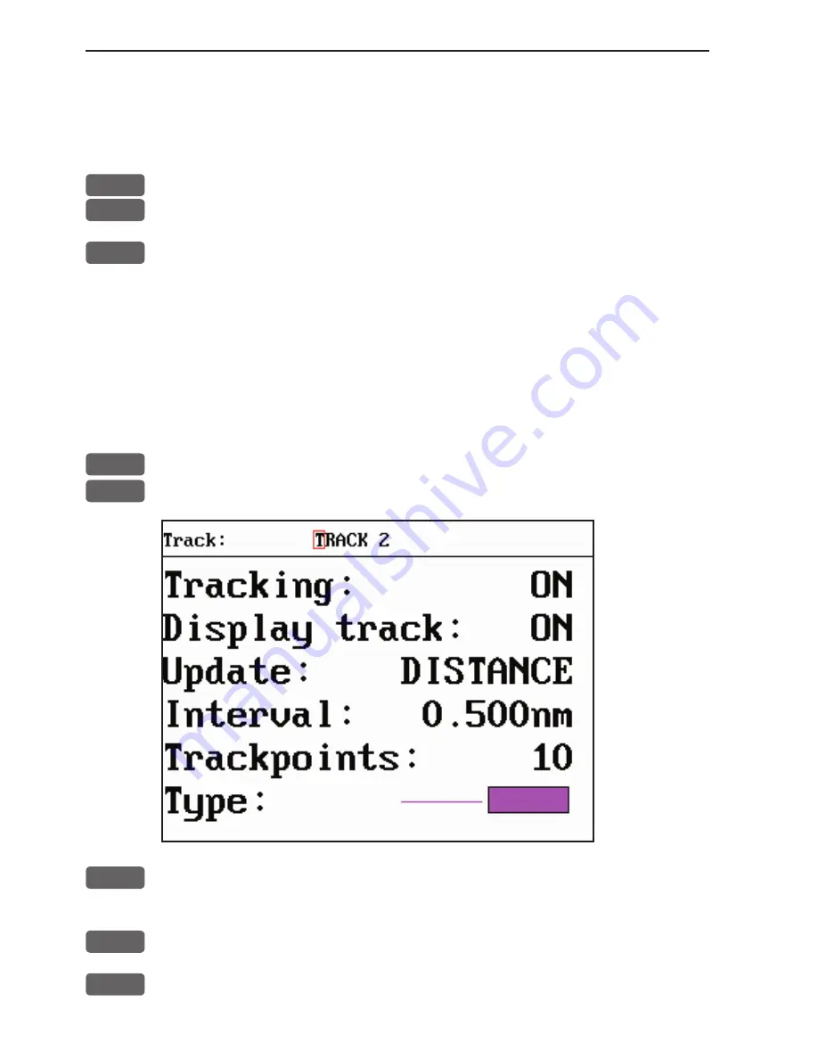
Type

 of track line i.e. full, dotted, etc. has 9 different types to 

choose from in 15 different colors.

To stop track:

PLOT


Call up the PLOT menu

7


Load Stop track pop-up window

ENT


Stop the highlighted track

8.6 Tracks stored in the memory

All tracks (of more than 1 trackpoint) will automatically be stored 
in the memory. To see which tracks are registered, you can scroll 
through the list by:

MENU


Call up the menu bar, and...

6,5


load “Tracks” in active window

A-Z

  Select name of track

- or if a number is included in the track name, place cursor on the 
number, and...

+/-

  Toggle up/down in track numbers

ENT

 Open 

for 

change

Summary of Contents for CR44

Page 1: ...ough SETUP menu or when unit is off All electronic navigation equipment is subject to external factors beyond the control of the manufacturer Therefore such equipment must be regarded as an aid to nav...

Page 2: ...g MOB Window 3 Window 1 Data display will provide information of Course Bear ing and Distance to MOB position time elapsed since the incident occured first in seconds and then in minutes if is shown i...

Page 3: ...2 4 Menu layout 2 6 2 5 Choice of symbols 2 7 2 6 Naming of routes points etc 2 7 2 7 Initial start up 2 7 2 8 Turn power off 2 8 Chapter 3 Radar menu 3 Radar operation 3 1 3 1 Radar map 3 1 3 1 1 Ma...

Page 4: ...or placed on route leg or line section 4 10 4 4 5 Cursor placed on routepoint or linepoint 4 11 4 4 6 Cursor placed on trackpoint 4 12 4 4 7 Cursor placed on target 4 13 4 4 8 GOTO menu 4 14 4 4 9 PLO...

Page 5: ...Waypoint route menu 8 Waypoint route menu 8 1 8 1 Waypoints stored in the memory 8 1 8 1 1 Delete waypoints via menu 8 2 8 2 Routes stored in the memory 8 3 8 2 1 Delete route via menu 8 6 8 2 2 Make...

Page 6: ...6 Palette setup 9 11 9 7 Factory settings 9 12 9 8 QuickGuide 9 14 Chapter 10 Troubleshooting Maintenance and Service 10 1 Troubleshooting 10 1 10 2 Preventive maintenance 10 2 10 3 Repair and service...

Page 7: ...been developed and is operated by the US Department of Defense in order to provide an accurate and reliable service which include a 24 hour global coverage The GPS system consists of approx 24 satell...

Page 8: ...o get cut on the sharp edges of the glass pieces The lifetime of the internal battery is minimum 5 years If not exchanged before it goes flat all data in the unit s memory will be lost We strongly rec...

Page 9: ...eration Your present position will automatically be updated within a few minutes When ready the ship symbol on the chart will flash the position coordinates will stop flashing and the will be replaced...

Page 10: ...between Highway Position Dual Speed Set Drift When navigation mode is active these two displays will be included ETA AVN Trim Highway PILOT Long press will toggle between Highway Custom screen1 Custo...

Page 11: ...ust range in smaller steps ENT Press ENT to call up the Radar quick menu with access to e g Show active navigation point on radar screen activate EBL VRM cursors etc EBL The EBL1 VRM1 cursors can also...

Page 12: ...seconds or till cursor is moved Press ENT 2 to access further details on C MAP objects or user data i e waypoints routes etc Press ENT 5 to lock cursors in Dual Chart screen and ENT 5 to release curs...

Page 13: ...e cursor up down to select the WP position for the first routepoint and press PLOT 4 Repeat point 3 to add new WP positions to the route the last routepoint in the right column is always empty allowin...

Page 14: ...ress ENT to start navigation Without placing cursor on the routepoint you wish to go to first 1 Press GOTO 3 2 Use the keys to select the name of the route 3 Use the cursor to go to routepoint number...

Page 15: ...sufficient informa tion for the operator In split screens consisting of up to four displays the active display is indicated by a solid red frame Use the WIN key to clockwise toggle between which disp...

Page 16: ...d e g PAGE Press the PAGE key until the full screen Chart display appears MENU Call up the menu bar and 2 collect the Dual Chart display or you can toggle between the available displays in the CHART f...

Page 17: ...two seconds to activate the MOB Man overboard function MENU Turns the menu bar on off Exits any data display without taking any action except the radar function ENT Confirms insertion and editing of...

Page 18: ...matic rotation of these pages Press any key to stop rotation ADJ Gives access to setup displays related to active display Scrolls through adjustable parameters EBL Toggles EBL1 VRM1 cursors on off WIN...

Page 19: ...key to highlight the function and press ENT If you want to switch to a different menu use the cursor key left right to move to the adjacent menu Most functions in the menus are general and can be cal...

Page 20: ...AVN 4 Loran C 4 Lines 5 Trim Highway 5 Satellites 5 Tracks 6 Set Drift 6 DGPS 6 Targets 7 Custom screen 1 7 SDGPS 7 MOB data 8 Custom screen 2 8 DSC info 8 Data transfer 7 SETUP When selecting a sub...

Page 21: ...u make a mistake Depending on the selected language the 0 zero key will hold special charac ters e g and the 9 nine key will hold empty space Press the CLR key to delete everything from cursor positio...

Page 22: ...has a valid position see section 6 3 Select display language MENU Call up the menu bar and 7 1 press 7 1 to call up the language display Press up on the cursor to go to the bottom line in the display...

Page 23: ...dead ahead bearing is indicated by the heading line at the 0 relative bearing Coastline contours and landmass are generally depicted in solid filled yellow purple multi colored DAY settings or green...

Page 24: ...ather effects reduce the long range at which targets can be detected Water surface clut ter waves reduces the ability to detect targets close by Either can obscure the echoes from targets that may pro...

Page 25: ...screen The cable target usually appears to be on a collision course The entire length of cable does not appear on the screen only a point on the cable and that point keeps changing giving the illusion...

Page 26: ...f targets that are sometimes difficult to distinguish from each other Their movement in the waves do not present a consistent reflecting surface Consequently their echoes have a tendency to fade and b...

Page 27: ...ging in size intensity and position These returns sometimes appear as large hazy areas on the display depending on the intensity of the rainfall or snow in the storm cell The cells usually may be visi...

Page 28: ...normally have no effect from distant or small surface objects but the echo from a large object at short range may produce an arc pattern on the radar screen similar to a range ring or appear as a ser...

Page 29: ...s Indirect echoes may appear when there is a large target such as a passing ship at a short range or a reflecting surface such as a funnel or spotlight on your own ship in line with the antenna The si...

Page 30: ...ide of the display Press ADJ to access the control menu where the most common adjustments are made see section 3 2 5 The Dual Radar display requires a full screen presentation with the standard displa...

Page 31: ...xchanged with a different display selected via the menu 3 2 2 Initial radar display setup After the installation has been completed there are a number of parameters to check out and adjust according t...

Page 32: ...lapsed transmission time Auto sea minimum 035 Auto sea and Auto gain are preset for best per formance under normal conditions only adjustable in X MIT mode More details on next pages Auto sea default...

Page 33: ...utions until weak echoes in the distance becomes acceptable Zero range timing Most common settings are between 105 and 115 Default setting depend on which scanner type is connected To adjust Press the...

Page 34: ...eys 2 Adjust Sea to minimum acceptable value move cursor to the Sea bar and adjust with keys 3 Set Tune bar to AUTO mode move cursor to the Tune bar and press CLR 4 Choose a displayed range of 3nm pre...

Page 35: ...visible on close range wait for screen to update to see the result of adjustment Auto Sea clutter adjustment bar example Level 055 070 160 Test scanner to activate press one of the keys which will cal...

Page 36: ...transmission Starting up the first time after installation or after long storage 6 months the antenna will need an extra 20 minutes to warm up so after Power on and going into Standby the radar must b...

Page 37: ...of the ship which will be exchanged with the position of the cursor when activated on the radar display heading input is required The control menu will appear in the right side of the radar display in...

Page 38: ...p in relative motion In this mode targets are dis played at their measured distances in true direction from your boat North being at the top of the display In the NU mode you must be interfaced with a...

Page 39: ...n or snow returns cause many small echoes continually changing in size and position to appear as a hazy area on the display Rain and snow targets do not have much depth By removing the leading edge th...

Page 40: ...n go to VRM1 and set the top bottom wall with keys Go to VRM2 and set the second of the top bottom wall Then go to GZ and choose IN the alarm will be activated if any target enters the defined guard z...

Page 41: ...m depending on the scanner type use keys Running 48 rpm is liable to reduce the lifetime of the mechanical parts HDG your heading will be shown full screen presentation in degrees from connected compa...

Page 42: ...placing the dashed circle over a target or over an object it will indicate the distance to same To turn off Press ENT 1 again to hide EBL1 VRM1 Long press on CLR will turn off all active cursors Toggl...

Page 43: ...see section 3 2 3 MENU Exit Radar quick menu 3 2 7 Dual radar display MENU Call up the menu bar and 1 2 load the Dual Radar display Standard radar display Secondary radar display This feature requires...

Page 44: ...values with the keys and insert data by the numeric keys ENT Confirm changes by pressing ENT or MENU To make adjustments in the secondary radar display WIN Make the secondary radar display active Carr...

Page 45: ...art scale is adjusted to approximately the same range as the radar When heading data is available and a cursor is active the chart cursor will be set to the radar cursor position The lock function is...

Page 46: ...deactivate the Off center mode press CLR and 0 This will replace the ship s position back at the center of the display If the radar system is turned off while the Off center mode is on at next power...

Page 47: ...wish Turning the navigation mode off will temporarily set it out of function because there is nothing to show but when you start navigating the function will become active again You do not have to tur...

Page 48: ...ect Demo with the keys ENT Accept change exit Radar setup ENT Call up Radar quick menu RADAR Turn Power on the legend Detecting will appear on the screen for a short while then a countdown of 20 secon...

Page 49: ...Turn Power off MENU Call up the menu bar and 7 Open the SETUP menu RADAR Load the Radar setup a warning will pop up that you are about to change settings for the radar press MENU to abandon or ENT to...

Page 50: ...Chapter 3 28 CR44 54 Radar menu...

Page 51: ...rt display will provide a chart in two different scales one for detail smaller range and one for overview greater range The two custom screens will present multiple window combina tions section 4 1 wh...

Page 52: ...toggle between different pres entations of the data field on the chart e g 4 1 1 Data field on chart Chart range indicator 0 11nm can be set ON OFF in Show range section 4 5 Chart setup under General...

Page 53: ...nstantly center the ship on the chart with cursor off 4 1 3 Cursor function With chart display active Press the cursor key to activate the chart cursor cross hairs CLR Press CLR to turn the chart curs...

Page 54: ...xtended level range is switched off and the chart changes to a new level of details The extended level range can be toggled OFF ON in General settings default OFF see section 4 5 Chart setup Chart det...

Page 55: ...nd indi vidual chart setup MENU Call up the menu bar and 2 2 press 2 and 2 to call up the Dual Chart display WIN Press the WIN key to select active display red frame ENT Press the ENT key to call up t...

Page 56: ...onsist of multiple window combinations e g The displays which are not related to the chart function can be exchanged with a different one It is also possible to change the right half of the screen fro...

Page 57: ...llowing to choose from Scale 1 6600000 Actual chart scale No user data at ship s position 1 Edit user data Inactive function 2 Chart info Refer to Appendix C 3 Find nearest port services Refer to Appe...

Page 58: ...rsors 0 Cursor to center PAGE More user data Inactive function MENU Exit Exit info window 4 Bearing dist from A to B will quickly provide the bearing and distance from your current cursor position A t...

Page 59: ...er to Appendix C 3 Find nearest port services Refer to Appendix C 4 Bearing and dist from A to B Refer to section 4 4 2 5 Lock cursors Refer to section 4 4 3 0 Cursor to center Refer to section 4 4 2...

Page 60: ...ndix C 3 Find nearest port services Refer to Appendix C 4 Bearing and dist from A to B Refer to section 4 4 2 5 Lock cursors Refer to section 4 4 3 0 Cursor to center Refer to section 4 4 2 PAGE More...

Page 61: ...Appendix C 4 Bearing and dist from A to B Refer to section 4 4 2 5 Lock cursors Refer to section 4 4 3 0 Cursor to center Refer to section 4 4 2 PAGE More user data MENU Exit Exit info window 1 Edit...

Page 62: ...Bearing and dist from A to B Refer to section 4 4 2 5 Lock cursors Refer to section 4 4 3 0 Cursor to center Refer to section 4 4 2 PAGE More user data MENU Exit Exit info window 1 Edit user data ope...

Page 63: ...info Refer to Appendix C 3 Find nearest port services Refer to Appendix C 4 Bearing and dist from A to B Refer to section 4 4 2 5 Lock cursors Refer to section 4 4 3 0 Cursor to center Refer to secti...

Page 64: ...igation examples Anchor guard when setting anchor a pre set alarm distance will be activated so in case the ship is drifting too far away from the anchored position the system will initiate a visual a...

Page 65: ...PLOT From any display Plot and save mark on ship s position including actual depth indication Preset name sequence SHIP 1 SHIP 2 etc 1 From any display Plot and save waypoint Ship s position is sug g...

Page 66: ...n case you make a wrong plot press CLR to erase the last plotted posi tion Save the route with ENT or exit the function with MENU to abandon the route Do not use the exact position of buoys markers et...

Page 67: ...BACKGROUND MENU Exit PAGE Next Accept ENT The left column indicates which levels are available in each display mode e g the above example shows that in FULL display mode you can access the levels in...

Page 68: ...l are fixed in all display modes except for Custom where it is possible by the user to turn a feature ON shown on the chart or OFF not shown on the chart etc These C MAP features are not available in...

Page 69: ...9m 9 MAX ON ON ON 0000m 9999m ON 0 002m 2 009m 9 MAX ON ON ON 0000m 5m ON 0 002m 2 009m 9 MAX ON ON ON 0000m 9999m ON 0 002m 2 009m 9 MAX OFF ON OFF 0000m 5m OFF 0 002m 2 009m 9 MAX Level Presentation...

Page 70: ...d tracks all lines and all targets are default to AS SELECTED the choices made for a particular route etc via the menu e g MENU 5 2 ENT ENT Edit route where Course line can be set ON or OFF AS SELECTE...

Page 71: ...the background water color on the chart Extended level range will enable changing range 3 4 steps within the same chart level after having selected the range via a numeric key Grid the LAT LON grid c...

Page 72: ...UP the chart will automatically turn so your bearing to destination is up If chart cursor is active it will stop the chart from rotating press CLR to turn cursor off RELATIVE motion the ship is posit...

Page 73: ...diagram 2 Custom screen 5 1 Depth temperature diagram MENU Call up the menu bar and 3 1 activate Depth temperature diagram Present water temperature and depth Depth over time or dis tance Temperature...

Page 74: ...om 0 10m to 0 3000m Toggle between values with keys Color for depth and temperature can be changed Toggle between available colors by means of the keys Scale for temperature can be set to 0 10 0 20 0...

Page 75: ...e not related to the Echo function i e all dis plays except the Depth temperature diagram in the top left quarter of the screen can be exchanged with a different one It is also pos sible to change the...

Page 76: ...Chapter 5 4 CR44 54 Echo menu...

Page 77: ...on The two custom screens will present multiple window combinations section 6 1 where the window in the top left quarter of the screen will present a fixed display from the pilot menu To access one of...

Page 78: ...screen 2 From one of the pilot displays i e full screen and active window in the top left quarter PILOT Short press on the PILOT key will toggle between Highway Position Dual Speed ETA AVN Trim Highwa...

Page 79: ...m 00 10nm ON Navigation mode RHUMBLINE Route navigation XTE alarm OFF Auto waypoint shift WP circle Track navigation XTE alarm 00 10nm OFF Auto trackpoint shift WP circle Navigation mode RHUMBLINE Tog...

Page 80: ...Route navigation the XTE alarm value can be specified for each route leg see section 8 2 Navigation mode RHUMBLINE navigation is used for shorter distances and GREAT CIRCLE for long trips especially...

Page 81: ...nded track between two waypoints XTE alarm lines refer to sec 9 4 for alarm setup Ship s posi tion and course in relation to intended track C Course over ground X XTE Cross track error S Speed over gr...

Page 82: ...date if for some reason there is no position update from GPS or external sensor the displayed position will start to flash and an alarm will be activated to alert the operator Reset the Posi tion miss...

Page 83: ...if ferential data The accuracy will typically be 2 5 meters for DGPS and 3 7 meters for SDGPS In order to utilize the high accuracy of the GPS system it is neces sary to align the lat long calculation...

Page 84: ...ected datum To select a new datum place the cursor next to Datum and key in a new number or go two spaces to the right 000 and leaf through the datum list with The datum in the chart display is fixed...

Page 85: ...scale MENU Call up the menu bar and 4 3 load Dual Speed display Water speed readout from connected log trans ducer Position with three decimals in minutes Analogue differential speed indicator scale D...

Page 86: ...automatically calculated in knots after you key in the planned arrival time and date In route navigation the approaching point and present speed over ground AUTO is automatically used for the calcula...

Page 87: ...on data from external log and compass The Trim Highway display will provide information on actual and mean speed velocity and water speed see also section 6 7 Set Drift display MENU Call up the menu...

Page 88: ...r and 4 6 load the Set Drift display Relative direction True direction Speed The Set Drift display will show how fast the current is moving in knots in what direction true it is moving and what direct...

Page 89: ...enu or via the menu Bottom left quarter window shows the Position display which can be exchanged with any display that will fit into a quarter window Right half screen shows the Chart display which ca...

Page 90: ...with indication of how fast the current is moving in knots in what direction true it is moving and what direction in relation to the vessel relative see section 6 7 These readings rely on data from ex...

Page 91: ...is stored in the memory Refer to section 4 4 9 PLOT menu CHART Shortcut to chart display Place cursor on destination waypoint GOTO Call up the GOTO menu and 2 Select Waypoint navigation mode This wil...

Page 92: ...k if any of the cur rent settings need to be changed e g forward or reverse direction in route ENT Start navigation From the chart without first placing cursor on a routepoint GOTO Call up the GOTO me...

Page 93: ...Track navigation will require that at least one track is stored in the memory Tracks which are not yet completed can not be used for navigation Refer to section 8 5 Start Stop track There are two ways...

Page 94: ...the window if anything needs to be changed such as Direction in track etc 0 9 Key in the number of the first trackpoint you wish to sail to ENT Start navigation A course line will now be drawn from s...

Page 95: ...ff again GOTO Call up the GOTO menu and 3 turn anchor guard off 6 11 MOB alarm and navigation The MOB Man overboard alarm and display will be activated if you press the MOB key on the CRXX keypad and...

Page 96: ...Chapter 6 20 CR44 54 Pilot menu navigation examples...

Page 97: ...4 Loran C see section 7 4 5 Satellites see section 7 5 6 DGPS see section 7 6 7 SDGPS see section 7 7 8 DSC info see section 7 8 7 1 Wind display The CRXX is ready to present wind data from connected...

Page 98: ...sh to change Toggle between settings or 0 9 Key in new figure ENT Confirm entry and return to Wind display Damping level can be set to LOW MEDIUM or HIGH The higher level the more steady and slow reac...

Page 99: ...e menu bar and 5 2 load Speed diagram S Speed over ground V Velocity towards waypoint W Speed through water SD Set and drift Speed and direction true or relative WIND Speed and direction Connection to...

Page 100: ...for the speed diagram can be adjusted in this display Time interval can be set in 8 intervals from 1 minute to 3 hours and freeze Go to the function you wish to change Key in new figure or change sett...

Page 101: ...1C 03 North Humber 2A 27 Bombay 7B 04 Holland 2E 28 Calcutta 8B 05 British 3B 29 Bangladesh 6C 06 Lofoten Norway 3E 30 Hokkaido 9C 07 German 3F 31 Tohoku 6C 08 N Baltic 4B 32 Kyusyu 7C 09 NW Spanish 4...

Page 102: ...ffset to the time delay toggle positive negative with ENT Confirm entry To change the position readouts to Loran C mode see section 9 2 under Pilot Position setup where Display position as can be tog...

Page 103: ...ites in the GPS system starting from left to right with the num bers 1 to 32 Satellite status bottom line indicates the satellite is healthy excluded or non existing satellite 0 satellite data is faul...

Page 104: ...ry in relation to 2D positioning and a fixed antenna altitude PDOP position dilution of precision is equivalent to 3D positioning The values will typically stay between 1 3 and 8 The lower the value t...

Page 105: ...endum part no 183 0122 501 MENU Call up the menu bar and 5 6 load DGPS setup display with built in module To receive valid differ ential data will require that the navigator is locked in on a beacon s...

Page 106: ...ve to use the received differential data with cau tion as there is no guarantee it is not faulty Frequency the frequency of the beacon station can be set manually if known However when left in AUTO th...

Page 107: ...messages ok NO Range used for position fix NO Type 0 warning received NO CHANNEL 2 sat no Corrections NONE Integrity messages ok NO Range used for position fix NO Type 0 warning received NO Ignore ty...

Page 108: ...n Integrity messages ok the SDGPS system will transmit messages concerning the integrity of the GPS satellites This line will indicate whether such messages are received and reliable Range used for po...

Page 109: ...r Number Name System Area 120 AOR E EGNOS EU Atlantic ocean region east 122 AOR W WAAS US Atlantic ocean region west 124 ARTEMIS EGNOS EU 126 INMARSAT EGNOS EU 129 MTSAT 1 MSAS JAPAN 131 IOR EGNOS EU...

Page 110: ...s code SIMB Simrad message B Datafelt 1 1 activate iDSC alarm 0 inactive iDSC alarm Datafelt 2 0 iDSC alarm acknowledged by CLR 1 iDSC alarm acknowledged by ENT The message from the VHF will appear i...

Page 111: ...ed in the memory The waypoint list will appear in alphabetical order and will include the waypoint s position in lat long To edit one of the stored way points MENU Call up the menu bar and 6 1 load wa...

Page 112: ...to ship s position ENT Confirm entry and return to WP list Plot new waypoints with the PLOT key refer to section 4 4 9 8 1 1 Delete waypoints via menu MENU Call up the menu bar and 6 1 load waypoint...

Page 113: ...via info windows refer to sec tions 4 4 4 and 4 4 5 To delete a route refer to section 8 2 1 Making new routes can be done directly on the chart with the PLOT function refer to section 4 4 9 or from t...

Page 114: ...up the Edit route display if you wish to make any changes Setting the Course line to OFF in this display will make the route invisible on the screen Put it back on the screen by setting it ON again Th...

Page 115: ...en available values if no more alterations are required go to ENT or you can insert remove routepoints from the route by entering a new display PLOT Open for the function Remove insert routepoints Exi...

Page 116: ...er as a route it is easily done via the route list MENU Call up the menu bar and 6 2 load route list CLR Make new route from WP list Use the cursor to go up down in the WP list to select the position...

Page 117: ...and go to the Edit display or leave the function with MENU to abandon the route In the Edit route display you can set up the route preferences you need and also change the name of the route Place the...

Page 118: ...u bar and 6 3 load route calculation display Toggle between available routes in the memory Go to Routepoint A and 0 9 Select the first routepoint A from where you wish to start the calcu lation in the...

Page 119: ...on the chart To draw new lines you need a chart in the active window place the cursor where you wish to start the line and press PLOT Then follow the instructions in the info windows Refer to section...

Page 120: ...type or color Toggle between available values ENT Confirm entry 8 4 1 Delete lines via menu MENU Call up the menu bar and 6 4 load line list Select the line you wish to delete ENT Open for editing WIN...

Page 121: ...the PLOT menu 7 Load Start track pop up window If you wish to change the default values Move cursor to where you wish to make a change Toggle between available values or 0 9 key in new values ENT Sta...

Page 122: ...the highlighted track 8 6 Tracks stored in the memory All tracks of more than 1 trackpoint will automatically be stored in the memory To see which tracks are registered you can scroll through the lis...

Page 123: ...lues ENT Confirm changes 8 6 1 Delete tracks via menu MENU Call up the menu bar and 6 5 load track display Select the track you wish to delete ENT Open for editing WIN Delete track CLR Confirm that yo...

Page 124: ...tted target position is automatically preset to actual position of ship or to cursor position when the chart display is active and the cursor is on see INFO windows section 4 4 7 MENU Call up the menu...

Page 125: ...you want to delete the selected target if not sure press MENU to exit the display without having made any changes Edit targets directly on the chart via info windows refer to section 4 4 7 8 8 MOB da...

Page 126: ...ve created plus the current setups in the internal memory of the unit Do it whenever you have added important data or when you wish to transfer routes and waypoints etc to another compatible unit The...

Page 127: ...atabank Use the cursor key to go to the Action column to decide which action you want taken for each mentioned category of data toggle with keys see section 8 9 1 If you choose to MERGE the data alrea...

Page 128: ...es DataCard Amount Bytes Internal after Amount Bytes Action Marks waypoints Lines Routes Targets Tracks Setup 9 244 0 0 1 168 0 0 8 190480 1 2501 11 256 2 168 4 408 1 100 0 0 1 1745 9 244 2 168 4 408...

Page 129: ...utomatically return to the active display on the screen before you made the transfer Transfer of Setup can only be completed between identical units MERGE will mix the transferred data with the data i...

Page 130: ...bol color XTE limit etc MENU Call up the menu bar and 6 8 load the Data transfer window Data transfer 1 DataCard upper drawer see section 8 9 3 DataCard lower drawer see section 8 9 7 NMEA connection...

Page 131: ...PC When the transmission is completed you will receive a new info window informing of how many routes were transferred MENU Exit function and return to normal NMEA communication Receive WPs and route...

Page 132: ...ot be included in the WP list Saving the collected data can take anywhere from less than a second and up to a few minutes depending on the amount of data If it takes too long and you need the CRXX in...

Page 133: ...ad are two watertight drawers wherein you place the C MAP cartridge C card you wish to load Do not attempt to insert or remove a cartridge unless the unit is turned off or chart reading is in stand by...

Page 134: ...hart there will be separate boundary lines for the individual charts stored on the same cartridge However the boundary lines for the C MAP chart areas can be turned off so they will not be visible on...

Page 135: ...the function you wish to change 0 9 Key in new values or Toggle between available values ENT Confirm editing Display position as the position can be shown in latitude longitude Loran C or decca coordi...

Page 136: ...d alarm units language MENU Call up the menu bar and 7 1 load Speed alarm units language display Setup for speed LOG speed sensor ON LOG speed calibration 019000 PULSES nm Speed alarm maximum SOG 000...

Page 137: ...nimum cruising speed This may be handy for trawl fishing entering harbors with speed limits etc Speed stability and time of response can be adjusted in Pilot Position setup press MENU 7 PILOT and use...

Page 138: ...erman D Italian I Nederlands NL Spanish E Swedish S and Portuguese P 9 4 Interface setup NMEA The CRXX has two in out ports 1 NMEA1 contains both an NMEA port and the connection for the dual station T...

Page 139: ...efault sentences Interface setup INPUT Port NMEA1 NMEA0183 NMEA2 NMEA0183 Sentence String Status NMEA Wind data Relative wind MWV ON 2 True wind MWV ON 2 Water data Water temperature MTW ON 2 Water sp...

Page 140: ...oint location WPL OFF OFF UTC time to destination WP ZTG OFF OFF Water data Water temperature MTW OFF OFF Water speed and heading VHW OFF OFF 9 4 2 Description of sentences Description of NMEA0183 ver...

Page 141: ...S Depth below surface DBK Depth below keel DBT Depth below transducer DPT Depth including offset Description of NMEA0183 external position heading and speed input Input is only valid when output is se...

Page 142: ...e settings ENT Confirm entry or MENU exit function without making any changes Stand by level can either be LOW 0 volt or HIGH 5 volt MOB input Press the external switch for more than 5 seconds to acti...

Page 143: ...et to bright daylight sunshine in 1 and 2 normal daylight in 3 and night setting in 4 These four setups are not adjustable Palette 5 to 9 can be customized to suit individual needs and wishes If you w...

Page 144: ...CTORY PRESETS If the unit is still alive but has ceased to respond to normal opera tion it could become necessary to return to the factory presets but first check Troubleshooting in section 10 1 Activ...

Page 145: ...n the unit is totally locked i e no immediate response from the keypad then first try to reset the unit by discon necting the power supply Reconnect the power cable and then start up the unit again by...

Page 146: ...either at start up in the Welcome to Simrad display press PAGE or via the menu MENU Call up the menu bar and 7 6 activate the QuickGuide PAGE Leaf through the information help text in the PAGE system...

Page 147: ...section 9 7 No GPS position update Check external position to be OFF refer to interface display in MENU 7 2 Check antenna and cable Replace antenna or cable Screen update is extremely slow Check that...

Page 148: ...Wring out firmly before wiping the unit Never use cleaning solutions containing spirit alcohol gasoline or oils Electrical connections periodically check the electrical connections Make sure that conn...

Page 149: ...er backlight 640x480 pixels CR44 10 4 in CR54 15 in Interfacing 2 ports in out NMEA 0183 0182 0180 PC up download WPL and RTE 1 port NMEA 2000 optional alarm Alarm relay contact closure log out 200 pu...

Page 150: ...40 DGPS antenna MGL 3 Type Quadrifilar Helix Patch and H field Dimensions L 230 mm H 75 mm D 38 mm D 127 mm Weight 150 g 0 33 lbs 600 g 1 3 lbs Environment 35 C to 75 C 95 rel Mounting 1 14 thread sta...

Page 151: ...to 24nm to 36nm Rotation speed 24rpm 24 or 48rpm Beamwidth Horizontal 5 9 3 9 Vertical 25 25 Cables 10m 104 3002 012 104 3002 015 15m 104 3002 013 104 3002 016 20m 104 3002 014 104 3002 017 30m 104 30...

Page 152: ...le 10 m RG58 Options Simrad DataCards C MAP NT electronic charts TL50 TurboLoader external disc drive and NMEA interface 6 channel NMEA Buffer RS5345 NMEA1 cable 1 5 m 9 pin male connector 153 3002 00...

Page 153: ...specifically to your needs You may set Units of measure feet fathoms meters etc Menu languages Scroll speed etc dGPS differential data is received from satellites via built in DGPS module or an exter...

Page 154: ...apter 5 The navigation simulator is started via the NMEA interface setup Press MENU 7 2 go to OFF next to External pos data and press the key to toggle to Dead reck move cursor to the right and enter...

Page 155: ...ing System will provide posi tion corrections from received satellite signals WAAS EGNOS and MSAS Speed Speed Over Ground measured in knots kilometers and miles TFT Thin Film Transistor Active matrix...

Page 156: ...low small or weak targets may be missed If the gain is set too high on short ranges the display may become excessively covered with noise speckle making target observation difficult On the longer ran...

Page 157: ...splay by pressing the PLOT key from the radar display and thereby save the position in the WP list as a waypoint i e you can give the plotted waypoint a new name number symbol color etc PPI center Pla...

Page 158: ...ing targets or own ship If the range scale is changed the trails are cleared and new trails histories will be redrawn to the screen The trails are drawn for anything that moves on the screen including...

Page 159: ...y 025 Campo Inchauspe 026 Canton Astro 1966 027 Cape 028 Cape Canaveral 029 Carthage 030 Chatham 1971 031 Chua Astro 032 Corrego Allegre 033 Djakarta 034 DOS 1968 035 Easter Island 1967 036 Gandajika...

Page 160: ...984 095 World Geodetic System 1972 096 World Geodetic System 1984 097 World Geodetic System 1984 098 World Geodetic System 1984 099 Lisboa Datum 100 Pulkovo 1942 101 North Am 1927 Alaska Can 102 South...

Page 161: ...mation place the cursor on a C MAP object and press ENT to call up an info window Scale 1 20000 Actual chart scale No user data at cursor position 1 Edit user data Inactive function 2 Chart info See d...

Page 162: ...be provided in relation to the ship s position ENT Press ENT from the chart display to call up the Info window 3 Find nearest port services will call up a list of symbols with rel evant information on...

Page 163: ...Port Marina symbol press ENT and 2 2 to call up the details on the facilities at this location Use the cursor key to scroll up down in the objects in the left colum and look in the right column for de...

Page 164: ...the cursor placed on the tide symbol press ENT to call up the INFO window 2 Press 2 to access chart info MENU Press MENU when you are ready to exit Tide height If you wish to see the low and high tide...

Page 165: ...information system is quite accurate However the predic tions are subject to variables which like the weather are beyond the control of man The tide predictions are based on normal weather conditions...

Page 166: ...ea Railway Road in general Overhead cable w pylons Overhead pipeline Fence line Telepheric Bridge Tunnel tunnel entrance Landmarks Building religious single Cemetery Fortifid structure Siloway route p...

Page 167: ...ving gear Scuba recharge Hotel Inn Restaurant Bank Exchange office Pharmacy Port Marina Boat hoist Fuel station Water Electricity Showers Laundrette Public toilets Post box Public telephone Refuse bin...

Page 168: ...conomic zone Fishery zone Fishing ground Free port area Harbor area administr Incineration area Log pond Military practice area National territorial area Restricted area Sea plane landing area Spoil g...

Page 169: ...menu 4 7 cursor active but not placed on any object or data 4 8 cursor inactive 4 7 cursor placed on route leg or line section 4 10 cursor placed on routepoint or linepoint 4 11 cursor placed on targ...

Page 170: ...ets 9 12 Introduction 1 1 Key functions 2 3 dedicated function keys 1 3 Key symbols in manual 1 2 Language 2 8 9 4 Light contrast 2 7 Lines delete all 8 10 draw new line 4 15 edit via chart 4 10 4 11...

Page 171: ...7 flashing 6 6 A 2 setup 9 3 start 9 3 update alarm 7 7 7 8 Power off 2 8 Power on 2 7 QuickGuide 9 13 Radar functions alarms 3 24 blind sectors 3 5 colors on screen 3 24 9 11 control menu 3 15 3 22...

Page 172: ...u 8 4 8 5 8 6 make new route from WP list 8 6 menu 8 1 navigation 6 16 navigation setup 6 3 plot new route 4 15 route list 8 3 stored in the memory 8 3 Routes continued time to go 8 8 Safety summary 1...

Page 173: ...delete all 9 12 edit via chart 4 9 edit via menu 8 2 menu 8 1 navigation 6 15 navigation setup 6 3 plot new waypoints 4 15 stored in the memory 8 1 WP list 8 1 Wind display 7 1 setup 7 2 wind directio...

Page 174: ...ment Annex II of 1999 5 EC internal production control Employed standards Article 3 1 a EN60945 Article 3 1 b EN60945 Equipment category Navigational equipment intended for world wide use aboard non S...

Page 175: ...s claimed to be defective ON BOARD SERVICE can be arranged by authorized local service dealers or national distributors upon request Labor costs for the repair replacement of the defective modules par...

Page 176: ..._____ EQUIPMENT ________________________________________________________________________ ____________________________________ ____________________________________ ______________________ ______________...

Page 177: ...______________________ ___________________________________________ TYPE __________________________________________________________ EQUIPMENT ___________________________________________________________...

Page 178: ...__________________________________ _________________________________________________________________________ _________________________________________________________________________ _________________...

Reviews: