background image

25

3.1.1.3 Selecting an intersection as the destination 

To enter an address as the destination, do as follows: 

1.  Select   after selecting   on the MAP screen.

2.  Select 

.

3.  If necessary, modify  he country and town as described earlier (page 20). 

4.  Enter  he street name: 

a.  Select 

b.  Start entering the street name on the keyboard. 
c.  Find the street you need:

• 

The most likely street name is always shown in the input 

 eld. To accept it, 

select  . 

• 

If the desired name does not show up, the names that match the string 

appear in a list after entering a couple of characters (to open the list of 

results before it appears automatically, select 

). Select  he street from 

the list. 


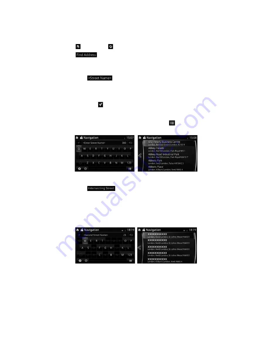
5.  Enter  he intersecting street name: 

1.  Select 

• 

If only a few intersecting streets exist, their list appears immediately. 

• 

In case of a longer street, the keyboard screen appears. Start entering 

the name of the intersecting street on the keyboard. As soon as the street 

names  hat match the entered string can be shown on one screen, their list 

appears automatically. Select the street from the list.


Summary of Contents for 2014 2

Page 1: ...2014 Mazda Motor Corporation Aug 2014 Print1...

Page 2: ......

Page 3: ...1 2 Entering the midpoint of a street as the destination 23 3 1 1 3 Selecting an intersection as the destination 25 3 1 1 4 Selecting a town centre as the destination 27 3 1 2 Selecting the destinati...

Page 4: ...c information in route planning Only some countries and regions 54 4 1 5 1 Historical traf c 54 4 1 5 2 Real time traf c information TMC 55 4 1 5 3 Online traf c information 56 4 2 Settings menu 57 4...

Page 5: ......

Page 6: ...y when it is safe to do so If you are the driver of the vehicle we recommend that you operate the navigation system before you start your journey Plan the route before your departure and stop if you n...

Page 7: ...hen inserting the SD card never move the slider on the side of he SD card to the LOCK position If the slider is set to LOCK the SD card cannot be read and the navigation system will not operate This S...

Page 8: ...al Search can be of fur her help to nd your destination Displays the screen where traf c information and the GPS reception conditions can be set and veri ed Cancels waypoint route Finds Places nearby...

Page 9: ...aps Lock Select again and lower case letters return Finalising the keyboard entry Select Accepting the suggested search result Saving your input Select Opening the list of search results Cancelling th...

Page 10: ...road if the map contains it Shows he distance you need to travel on he route before reaching your nal destination Shows he estimated arrival ime at the nal destination of he route If the navigation s...

Page 11: ...location of the Cursor can be used as the destination of the route You can search for a POI point of interest or you can save it as one of your Favourites destinations You can also select some of the...

Page 12: ...th he event type such as turning detouring exiting expressways and the distance from the current position When the next event approaches the second event is displayed using a small icon If there is no...

Page 13: ...tion you need to take Lane guidance is provided constantly if there is map information Signposts are displayed at the top of the map The colour and style of the signposts are similar to the real ones...

Page 14: ...n the map when you are driving on motorways Select this Open button to open a panel with he details of the next few exits or service stations Applicable only when the setting is Only when menu is open...

Page 15: ...int The nal destination of the route Route colour The route always stands out with its colour on the map both in daytime and in nighttime mode Streets and roads that are excluded from the navigation Y...

Page 16: ...content Map scaling has a limit in 3D map view mode If you zoom out further the map switches to 2D view mode Select the button once to modify the view in large steps or select and hold the button to...

Page 17: ...ar and navigation continues 2D or 3D view When this button is selected the map view mode can be changed The map is displayed so hat north is up regardless of the direction of travel The map is rotated...

Page 18: ...is screen contains information about the current position or about the last known position if GPS reception is not available You can access this screen from the map in one of the following ways 1 Sele...

Page 19: ...u can add as many destinations to your route as you like 3 1 Selecting the destination of a route The navigation system offers you several ways of choosing your destination Enter a full address or a p...

Page 20: ...s or part of a facility name is input a search candidate list including the input characters is displayed The greater the number of characters input the more the list is re ned 3 1 1 1 Entering an add...

Page 21: ...aracters to open the list of results before it appears automatically select Select he town from the list 5 Enter he street name a Select b Start entering the street name on the keyboard c Find the str...

Page 22: ...en by selecting or it returns to the previous screen by selecting the button By touching the location displayed on the screen you can change the destination to anywhere on the map Note You can search...

Page 23: ...as described earlier page 20 4 Enter he street name a Select b Start entering the street name on the keyboard c Find the street you need The most likely street name is always shown in the input eld To...

Page 24: ...e button By touching the location displayed on the screen you can change the destination to anywhere on the map Note You can search for POI point of interest around the selected location The selected...

Page 25: ...elect If the desired name does not show up the names that match the string appear in a list after entering a couple of characters to open the list of results before it appears automatically select Sel...

Page 26: ...creen you can change the destination to anywhere on the map Note You can search for POI point of interest around the selected location The selected location can be registered to Favourites 7 Navigatio...

Page 27: ...ry and town as described earlier page 20 4 Enter he street name a Select b Start entering the street name on the keyboard c Find the street you need The most likely street name is always shown in the...

Page 28: ...creen you can change the destination to anywhere on the map Note You can search for POI point of interest around the selected location The selected location can be registered to Favourites 7 Navigatio...

Page 29: ...int of interest with only a few screen selects using the Preset search feature You can search for a POI point of interest by its category You can search for a POI point of interest by its name 3 1 2 1...

Page 30: ...select to open the list of POI point of interest with names containing the entered character sequence 6 The selected location is shown on the map The system transitions to the next screen by selecting...

Page 31: ...ation starts if is selected or after 10 seconds of no user interaction By touching the location displayed on the screen you can verify the route Additionally the route can be revised by selecting othe...

Page 32: ...around the last known position if the current position is not available 4 Select any of the quick search buttons to get an instant list of Places 5 The selected location is shown on the map The system...

Page 33: ...current position or if it is not available around the last know position The result list will be ordered by the distance from this position Select to search along the active route and not around a giv...

Page 34: ...along the route 7 Select one of the Place subcategories e g Hotel or Motel or select to list all Places in the selected main category around the selected location or along the route 8 Sometimes the li...

Page 35: ...creen you can change the destination to anywhere on the map Note You can search for POI point of interest around the selected location The selected location can be registered to Favourites 11 Navigati...

Page 36: ...ct to search along the active route and not around a given point This is useful when you search for a later stopover that results in a minimal detour only such as searching for upcoming petrol station...

Page 37: ...in or select to search in the selected Place category 8 Select if you have not done it before 9 Using the keyboard start entering the name of the Place 10 After entering a few letters select to open...

Page 38: ...creen you can change the destination to anywhere on the map Note You can search for POI point of interest around the selected location The selected location can be registered to Favourites 12 Navigati...

Page 39: ...The local search is carried out around your current location To search around a different location enter the name of the town after the word you are looking for You can enter up to 25 characters 4 Aft...

Page 40: ...By touching the location displayed on the screen you can verify the route Additionally the route can be revised by selecting other options 3 1 4 Selecting a map location as the destination 1 Touch an...

Page 41: ...creen you can change the destination to anywhere on the map Note You can search for POI point of interest around the selected location The selected location can be registered to Favourites 5 Navigatio...

Page 42: ...lecting or it returns to the previous screen by selecting the button By touching the location displayed on the screen you can change the destination to anywhere on the map Note You can search for POI...

Page 43: ...ered by time they were last selected If necessary scroll the list to see earlier destinations 4 Select a destination from the list 5 The selected location is shown on the map The system transitions to...

Page 44: ...ify the route Additionally the route can be revised by selecting other options 3 1 7 Entering the coordinate of the destination You can also select a destination by entering its coordinate as follows...

Page 45: ...creen you can change the destination to anywhere on the map Note You can search for POI point of interest around the selected location The selected location can be registered to Favourites 7 Navigatio...

Page 46: ...isplayed The name and or address of the destination The total time of the route The total length of the route The route planning method e g Fast 3 You have the following options on this screen for det...

Page 47: ...destination to the route or append the newly selected destination at the end of the current route Select to plan a new route to the newly selected location The previous destination and waypoint s are...

Page 48: ...tion or waypoint Add the new destination or waypoint Start the route plan in consideration of the selected destination or waypoint 4 Select the destination or waypoint to display the menu Close the me...

Page 49: ...ct after selecting on the MAP screen 2 Select 3 The four route alternatives are displayed next to the selected route planning method Select one to view it on the map 4 Details of a route can be checke...

Page 50: ...roads pay roads where there is a per use charge in the routes by default If you disable toll roads the navigation system plans the best toll free route The navigation system includes ferries in a pla...

Page 51: ...the commander switch 2 Select the Navigation tab 3 The list of Favourite destinations is displayed The following functions can be used by selecting Add Edit Navigation Favourite Add Current Location...

Page 52: ...e of all possible routes This method combines the merits of the Fast and Short routes The navigation system makes a calculation for the Fast route but it also includes other roads in the calcula ion i...

Page 53: ...speed limit while approaching he point Always The type of the alert point its distance and the related speed limit appear on the Map screen while you are approaching one of these points For some of t...

Page 54: ...can be taken into account in the route calculation based on the time of day and the day of week whenever suitable data exists In addi ion real time traf c information can help you avoid current traf c...

Page 55: ...ch the FM radio stations for TMC data and the decoded informa ion will immediately be used in route planning When Mazda navigation system receives traf c information that may affect your route the pro...

Page 56: ...lculating the route and navigation will continue with a new route that is optimal considering the most up to date traf c conditions To ne tune this recalculation you can set the minimum delay that can...

Page 57: ...r needs show or hide 3D buildings and manage POI point of interest display settings which POI to show on map A guidance related setting is available during route guidance A setting related to warnings...

Page 58: ...peed limit warning display can be changed No display and sound Only display Both sound and display A setting is available which sounds a beep at alert points and it can be set to on or off In addition...

Page 59: ...online The rest of the buttons below are all related to this real time information and are available only if receiving is enabled You can also de ne whether to receive online traf c only when connecte...

Page 60: ...disable toll roads the navigation system plans the best toll free route The naviga ion system includes ferries in a planned route by default However a map does not necessarily contain information abou...

Page 61: ...of the direction of travel Adjust the basic zoom and tilt levels to your needs Three levels are available During route guidance in any map view mode the function for zooming in on approaching intersec...

Page 62: ...t or a complex intersection and the needed information exists the map is replaced with a 3D view of the junction You can turn this feature on or let the map be displayed for the whole route When enter...

Page 63: ...Fi area By connecting the audio unit with a Wi Fi compatible device the Real Time Traf c function of the navigation system can be used Wi Fi Wi Fi Alliance and the logo are the trademark or registere...

Page 64: ...its security type and the radio wave reception level are displayed If the connection to a network is lost connection to another available network is automatic 5 2 2 Adding a network To connect to a n...

Page 65: ...i Fi if it is off 2 The available networks are displayed 3 Select a desired network Note If a public Wi Fi network is selected password input may be required 5 2 3 Stopping connection to network 1 Sel...

Page 66: ...ersections Colour theme The navigation system has different colour themes for daytime and nighttime which can be selected as desired One daytime scheme and one nighttime scheme is always selected for...

Page 67: ...and regions Special alert points for speed red light or bus lane cameras Different data sources are available You can con gure the navigation system to warn you when you approach one of these cameras...

Page 68: ...remove any copyright notices that appear and do not modify the Data in any way You agree not to otherwise reproduce copy modify decompile disassemble create any derivative works of or reverse enginee...

Page 69: ...direct product thereof except in compliance with and with all licenses and approvals required under applicable export laws rules and regulations Entire Agreement These terms and conditions constitute...

Page 70: ...d in FAR 2 101 and is subject to these End User Terms under which this Data was provided 200X NAVTEQ All rights reserved If the Contrac ing Of cer federal government agency or any federal of cial refu...

Reviews: