background image

104

Tip:

In some urban areas, businesses are so close to one another that
their POI icons crowd each other on the screen. In the preceding
figure, you can see a jumbled pile of POIs along Highway 34. You
can reduce screen clutter and make streets and other map features
easier to see by turning off the 

display

 of POIs you're not watching

for. (To see how, check the text on Map Detail Category Selection,
page 148.)

The Map Page has its own menu, which is used for several functions
and for setting various options. To access the Map Page Menu, from the
Map Page, press 

MENU

.

The Pages Menu also offers several map display options under the Map
Page category. To access them, press 

PAGES

|

 or

 to 

M

AP

|

 to

Option

|

EXIT

.

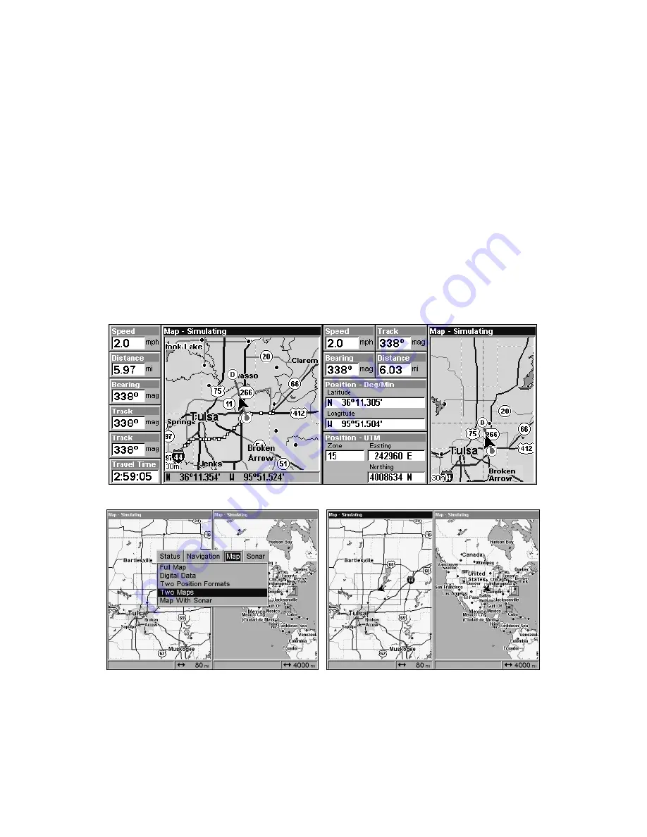
Digital Data map page (left); Two Position Formats page (right).


Pages Menu with Two Maps option selected (left).

Map Page with two map windows (right). The left map is active.

In pages that have two major windows (such as two maps) you can toggle
back and forth between the two windows by pressing 

PAGES

|

PAGES

.

This allows you to change which map the cursor, keyboard and menus

Summary of Contents for LCX-20C

Page 1: ...Pub 988 0151 261 www lowrance com LCX 20C Fish finding Sonar Mapping GPS Operation Instructions...

Page 2: ...demark of Fishing Hot Spots Inc Navionics is a registered trademark of Navionics Inc eXitSource Database copyright 2001 2004 Zenrin Co Ltd Exit Authority and eXitSource are trademarks of Zenrin Co Ltd...

Page 3: ...EPARATION 22 Speed Temperature Sensors 27 GPS Antenna Receiver Module 28 Power Connections 31 Powering a NMEA 2000 Buss 32 Powering Your Unit 32 NMEA 2000 Cable Connections 34 Connecting to a NMEA 200...

Page 4: ...Speed HyperScroll 74 Reset Options 75 Reset Water Distance 76 Set Keel Offset 76 Sensitivity Auto Sensitivity 77 Automatic Sensitivity 78 Sonar Chart Mode 79 Sonar Page Sonar Chart Display Options 79...

Page 5: ...15 Navigate to a Point of Interest 117 Creating and Saving a Trail 117 Displaying a Saved Trail 119 Navigating Trails 119 Visual Trailing 120 Navigate a Trail forward 120 Transfer Custom Maps and GPS...

Page 6: ...t by Average Position 135 Set a Waypoint by Projecting a Position 135 Section 8 System GPS Setup Options 137 Alarms 137 Auto Satellite Search 138 Check MMC Files and Storage Space 138 Communications P...

Page 7: ...rail Options 161 Delete All Trails 162 Update Trail Option 162 Update Trail Criteria Auto Time Distance 162 Trail Update Rate Time Distance 162 Specific Trail Options 163 Delete Trail 163 New Trail 16...

Page 8: ...ng to a waypoint but will also visually check to make sure a clear safe path to the waypoint is always available WARNING When a GPS unit is used in a vehicle the vehicle operator is solely responsible...

Page 9: ...ad the whole thing from front to back to find the information you want At the start or end of each segment we ll tell you what content is coming up next If it s a concept you re already familiar with...

Page 10: ...Section 7 This unit is ready to use right out of the box but you can fine tune and customize its operation with dozens of options Since sonar is the unit s key feature we put the main sonar options i...

Page 11: ...SD card compatible Back up memory Built in memory stores sonar records and GPS data for decades User settings are stored when unit is turned off Languages 10 languages selectable by user Sonar Freque...

Page 12: ...ftware optional optional plug and play LEI FreedomMaps offer the same high detail without the computer work of MapCreate Other plug and play mapping options include IMS Fishing Hot Spots LEI NauticPat...

Page 13: ...tter emits an electrical impulse which the transducer converts into a sound wave and sends into the water The sound frequency can t be heard by humans or fish The sound wave strikes an object fish str...

Page 14: ...ou to GPS and WAAS Your unit listens to signals from as many satellites as it can see above the horizon eliminates the weakest signals then computes its location in relation to those satellites Once i...

Page 15: ...mory NOTE No matter where they come from GPS Data Files must be loaded from the MMC into memory before the unit can use them The other key GPS use for MMCs is storage of special high detail custom map...

Page 16: ...verhead twice daily A series of ground stations with precisely surveyed locations controls the satellites and monitors their exact locations in the sky Each satellite broadcasts a low power signal tha...

Page 17: ...ion even more accurate Your unit receives both GPS and WAAS signals WAAS however has some limits you should know about First the U S government has not completed construction of the WAAS system so it...

Page 18: ...r option from a menu or take an action of some kind with the menu item Text that you may need to enter or file names you need to select are show in italic type such as trail name Instructions Menu Seq...

Page 19: ...ansducer and route the transducer cable to the sonar GPS unit 6 Install the GPS antenna and route the antenna cable to the sonar GPS unit 7 Install the power cable and route it to the sonar GPS unit 8...

Page 20: ...able wrenches drill 20 0 161 drill bit flat head screwdriver Supplies four 1 long 12 stainless steel slotted wood screws high quality marine grade above or below waterline sealant adhesive compound Si...

Page 21: ...e but the principle is the same for Skimmers inside a hull 4 If the transducer is mounted on the transom make sure it doesn t interfere with the trailer or hauling of the boat Also don t mount it clos...

Page 22: ...higher for more protection There are two extremes you should avoid Never let the edge of the mounting bracket extend below the bottom of the hull Never let the bottom the face of the transducer rise a...

Page 23: ...n at the end of this lesson to determine if you can satisfactorily shoot through the hull Transom Transducer Assembly And Mounting The best way to install these transducers is to loosely assemble all...

Page 24: ...ers molded into each ratchet Place the ratchets into the bracket with the letter A aligned with the alignment mark molded into the bracket Place the ratchets onto the transducer with the letter A alig...

Page 25: ...er s face isn t parallel with the ground remove the transducer and ratchets from the bracket Place the ratchets into the holes in the bracket with the letter B aligned with the dot stamped in the brac...

Page 26: ...d with the bracket alignment mark Place them on the transducer aligned with the 12 o clock position on the transducer stem Reassemble the transducer and bracket and place them against the transom Agai...

Page 27: ...t for the mounting screw pilot holes You will drill one hole in the center of each slot Drill the holes For the one piece bracket use the 29 bit for the 10 screws For the two piece bracket use the 20...

Page 28: ...to the sonar unit Make sure to leave some slack in the cable at the transducer If possible route the transducer cable away from other wiring on the boat Electrical noise from the engine s wiring bilg...

Page 29: ...internal tooth washer is supplied with the TMB S Attach motor mounting bracket to transducer 2 Slide the adjustable strap supplied with the TMB S through the slot in the transducer bracket and wrap i...

Page 30: ...k half of the arch is printed then the nose of the transducer is angled too far down and needs to be raised NOTE Periodically wash the transducer s face with soap and water to remove any oil film Oil...

Page 31: ...cures for 24 hours fill the remaining space with polyester resin When the job is finished the hull is watertight and structurally sound Remember the sonar signal must pass through solid fiberglass Any...

Page 32: ...epth Range and ASP Try a range setting that is two to three times the water depth The harder more rocky the bottom the easier it will be to get a second bottom signal Don t touch the controls once the...

Page 33: ...t your selected location will work under all conditions make a test run with the boat on plane and observe the bottom signal You ll need to figure some way to prop the transducer into position while y...

Page 34: ...shown in the previous figure Make sure there are no air pockets in the epoxy layer Then apply the remaining epoxy to the sanded area on the hull 3 Press the transducer into the epoxy twisting and tur...

Page 35: ...nsom where the water flow is smoothest Don t mount the sensor behind strakes or ribs These will disturb the water flow to the speed sensor Make sure the sensor will remain in the water when the boat i...

Page 36: ...ll a hole in the transom for the cable make sure it is located above the waterline After installation be sure to seal the hole with the same marine grade above or below waterline sealant used for the...

Page 37: ...981 for complete installation instructions In an automobile you may achieve good results by simply placing the external antenna on the top of the dash at the base of the windshield A piece of the rub...

Page 38: ...adapter to connect both the antenna and the unit to the same network port To do this simply remove the 60 ohm terminator shown in the previous image and attach the NMEA 2000 buss adapter cable to the...

Page 39: ...is a power cable that connects to a NMEA 2000 buss The thicker three wire cable red black and white is the Power Supply for your unit and optional external speaker connection for some units The Power...

Page 40: ...ife but if this small draw is a concern you can install a switch between the NMEA 2000 buss and the battery Powering Your Unit Power Supply cable red and black wires The unit works from a 12 volt batt...

Page 41: ...fuse holder directly to the battery or power buss This will protect both the unit and the power cable in the event of a short It uses a 3 amp fuse Power connections for LCX 20C sonar GPS unit NOTE If...

Page 42: ...your Lowrance unit is designed to work with a NMEA 2000 network as soon as it becomes available Connecting to a NMEA 2000 Network Your unit can be connected to a NMEA 2000 buss receiving sensor inform...

Page 43: ...2000 Power cable to form the power data cable shown earlier Com 1 uses the yellow wire to transmit the orange wire to receive and the shield wire for signal ground Your unit does not use the blue wir...

Page 44: ...bracket It can also be installed in the dash or mounted on a portable power supply Sonar unit rear view GPS antenna module Power Data socket LGC 2000 25 extension cable NMEA 2000 Power Cable Sonar soc...

Page 45: ...ation provided there is clearance behind the unit when it s tilted for the best viewing angle You should also make sure there is enough room behind the unit to attach the power transducer and GPS ante...

Page 46: ...our unit Once a location is determined use the bracket as a template and mark the mounting holes and the hole for the cables Drill a 1 inch 25 4 mm hole in the dash for the power transducer and antenn...

Page 47: ...sh you can fill in the hole around the cables with a good marine caulking compound No matter what type of installation you prefer be sure to leave enough slack in the cables to allow tilting or swivel...

Page 48: ...e will use the term MMC but just remember your unit can use an MMC or SD card to store data Both of these solid state flash memory devices are about the size of a postage stamp A SD card is slightly t...

Page 49: ...rds MMC card readers and MapCreate 6 custom mapping software for your computer MMC card readers are available in USB versions MapCreate 6 CD ROM left MMC card reader for USB ports right Switch Boxes T...

Page 50: ...vehicle is moving at high speed This includes towing a boat on a trailer at highway speeds Otherwise wind blast can pop off the cover Now that you have your unit installed move on to Sec 3 Basic Sona...

Page 51: ...phabetical order Before you turn on the unit it s a good idea to learn about the different keys the Main Menu the four Page screens and how they all work together BUT if you just can t wait to get on...

Page 52: ...search for waypoints and access the waypoint list It also launches the Point of Interest POI search menus and is involved in some navigation functions 8 ZOUT Zoom Out This key lets you zoom the scree...

Page 53: ...he menu screen and return to the page display press EXIT Remember our text style for MENU MENU means press the Menu key twice See a full explanation of our instruction text formatting on page 10 Instr...

Page 54: ...command this allows you to view the installed MMC card and the files it contains Pages The unit has four Page displays that represent the four major operating modes They are the Satellite Status Page...

Page 55: ...e Status Page Navigation Page This screen has a compass rose that not only shows your direction of travel but also the direction to a recalled waypoint To get to the Navigation Page Press PAGES or to...

Page 56: ...a GPS function so it is discussed in much greater detail in Sec 6 Sonar Page The Sonar Page displays the sonar chart This is a cross section view of the water column beneath the boat The chart moves...

Page 57: ...onar chart display option commands left Sonar Page in full sonar chart display mode right Sonar chart display options from left split zoom and split frequency Sonar chart display options from left dig...

Page 58: ...ll of those features and options in Sec 4 but to show you how easy the unit is to operate the following page contains a simplified 10 step quick reference that will cover most fish finding situations...

Page 59: ...n of the screen The full sonar chart will scroll from right to left showing you what s under the boat as you cruise across the water You can change the display by Zoom in to enlarge the chart for more...

Page 60: ...tions when too much clutter appears on the screen Decreasing the sensitivity can reduce the clutter and show the strongest fish echoes if fish are present As you change the sensitivity setting you can...

Page 61: ...ithout cruise control you have complete manual control of the car s speed In this unit manual mode allows you to set sensitivity at 100 percent maximum or zero percent minimum Depending on water condi...

Page 62: ...processor is remarkably powerful but it can be fooled Some of the echoes calculated to be fish could be tree limbs or turtles To see what s under your boat in maximum detail we recommend you turn off...

Page 63: ...d Operates like a Windows Multimedia Player with forward reverse pause fast forward fast reverse and scroll buttons Adjustments update the entire record displayed Can print in full color Window can dy...

Page 64: ...actly like your real sonar GPS unit Using the Sonar Simulator and GPS Simulator features it allows you to play back sonar logs run GPS routes and trails even create real waypoints you can use in the f...

Page 65: ...ne In all cases noise can produce unwanted marks on the display The ASP feature has four settings Off Low Medium and High If you have high noise levels try using the High ASP setting However if you ar...

Page 66: ...the deep alarm s setting For example if you set the shallow alarm to 10 feet the alarm will sound a tone if the bottom signal is less than 10 feet It will continue to sound until the bottom goes deep...

Page 67: ...ABLED ENT EXIT EXIT EXIT 5 To turn off the alarm press MENU MENU to ALARMS ENT to SONAR ALARMS ENT to DEEP ALARM ENABLED ENT EXIT EXIT EXIT To switch to a different depth setting open the Sonar Alarms...

Page 68: ...or other suspended objects are detected by the Fish I D feature Fish I D must be turned on for the Fish Alarm to work A different tone sounds for each fish symbol size shown on the display Sonar Alar...

Page 69: ...t number and repeat until the percentage is correct then press EXIT Chart Speed The rate echoes scroll across the screen is called the chart speed The default is maximum We recommend you leave the set...

Page 70: ...inged with red or a little yellow Since fish are among the weakest echoes they show up mostly as blue arches A hard bottom or other relatively hard target returns a strong signal displayed as a wide b...

Page 71: ...are near the left structure but the right structure shows fish holding next to the structure Depth Cursor The depth cursor consists of a horizontal line with a digital depth box on the right side The...

Page 72: ...cursor line press to raise the cursor line 3 To clear the depth cursor press EXIT Depth Range Automatic When turned on for the first time the bottom signal is automatically placed in the lower half o...

Page 73: ...IT to clear the menu To turn Auto Depth Range on again From the Sonar Page press MENU to AUTO DEPTH RANGE ENT EXIT NOTE The sonar s depth capability depends on the transducer installation water and bo...

Page 74: ...irst number then press to move the cursor to the next number and repeat until the depth is correct then press EXIT EXIT EXIT Normal display in auto depth range mode left Display zoomed with Upper and...

Page 75: ...a small fish a medium fish symbol on a larger target and so on The sonar s microcomputer is sophisticated but it can be fooled It can t distinguish between fish and other suspended objects such as tr...

Page 76: ...eat the instructions in step 1 Figures 1A and 2A left show Sonar Page in normal chart mode Figures 1B and 2B right show the same underwater scene with Fish I D turned on Note how arches are replaced w...

Page 77: ...owing Fish I D symbols and FishTrack depths turned on right Frequency Change Transducer Frequency Dual Frequency Transducers only A dual frequency transducer operates with both 200 kHz and 50 kHz The...

Page 78: ...enu To change the frequency setting to 200 kHz 1 From the Sonar Page press MENU to SONAR FEATURES ENT 2 Press to 200 KHZ ENT 3 Press EXIT EXIT to clear the menu HyperScroll See the entry on Ping Speed...

Page 79: ...t different commands Select FILE NAME if you want to change the name Select CHART QUALITY if you want to lower the file quality and record for a longer period of time After you ve changed the settings...

Page 80: ...collapsed to hide its contents Just select the category and press ENT 3 Expand any categories that might contain data you want to display Then press or to select a data option 4 With the data option h...

Page 81: ...and to move the data to a new location on the screen 4 When satisfied press EXIT EXIT NOTE The Customize command and the Overlay Data command both use the same information categories The difference b...

Page 82: ...een update you may want to use the HyperScroll feature When you change the Ping Speed to any setting greater than 50 percent the unit automatically enters HyperScroll mode These faster ping rates allo...

Page 83: ...the width of the FasTrack bar graph display doubles in width at the right side of the screen This allows you to better see the virtually instantaneous sonar returns just as you would on a flasher sona...

Page 84: ...e of the transducer Since the transducer is installed below the water surface the depth displayed by the digital depth chart depth scale chart cursor or fish symbols is not exact If the transducer is...

Page 85: ...o the surface the water line on the boat In this example we will use 1 5 feet This will be entered as a positive 1 5 feet which makes the depth indicators perform as if the transducer s higher in the...

Page 86: ...he control bar used to adjust sensitivity up or down is the same whether the unit is in the automatic or manual mode In automatic you can adjust sensitivity up to 100 percent but the unit will limit y...

Page 87: ...as the chart scrolls You can see the changes on the screen as you press the up or down arrows This is handy when there s a lot of clutter in the water and you are matching the sensitivity to rapidly...

Page 88: ...een represents the surface The bottom depth and surface temperature if equipped with a temperature sensor or a transducer with a temp sensor built in show at the top left corner of the screen The FasT...

Page 89: ...o 4X Split Frequency Sonar Chart Dual Frequency Transducers only This page option shows sonar data from the 50 kHz transducer element on the left side of the screen and data from the 200 kHz transduce...

Page 90: ...each window Digital Data Chart This mode shows the chart on the right side of the screen The left side has four digital boxes containing Depth Track Bearing and a Temperature Graph Digital Data Chart...

Page 91: ...category name and pressing ENT will show the category s contents so you can choose items within it An expanded category one with a next to its name can be collapsed to hide its contents Just select th...

Page 92: ...its the screen in half with the map on the left and the sonar on the right This screen option can be found on the Pages Menu under the Map Page category Map with Sonar split screen When this screen is...

Page 93: ...n Menu with Sonar Setup command selected left Sonar Simulator menu with simulator turned on right NOTE With Simulate Position checked the simulator will also automatically run the GPS simulator if GPS...

Page 94: ...g to another by opening the Sonar Simulator menu and using the instructions in step 2 to select a different chart NOTE If you turn on your unit before attaching a transducer it may enter a demo mode T...

Page 95: ...ces or eliminates surface clutter signals from the display It does this by changing the sensitivity of the receiver decreasing it near the surface and gradually increasing it as the depth increases Th...

Page 96: ...dable A low transparency will usually make menu text easier to read at the cost of watching your display Experiment with this feature until you find the right level of transparency for your eyes Main...

Page 97: ...d bottom of the 2X zoom bar Pressing the key again will give a 4X zoom and only the echoes between the top and bottom of the 4X bar will show on the screen Press the Zoom Out key ZOUT to return the di...

Page 98: ...90 Notes...

Page 99: ...mode make sure that either the transducer or the antenna is securely connected before turning the unit on Unit freezes locks up or operates erratically 1 Electrical noise from the boat s motor trolli...

Page 100: ...The technical term for this is cavitation 2 Electrical noise from the boat s motor can interfere with the sonar This causes the sonar to automatically increase its Discrimination or noise rejection f...

Page 101: ...ansducer cable away from the wiring that is causing the interference VHF radio antenna cables radiate noise when transmitting so be certain to keep the sonar s wires away from it You may need to route...

Page 102: ...94 Notes...

Page 103: ...s a good idea to learn about the different keys the four Page screens and how they all work together BUT if you just can t wait to get outside turn to the one page Quick Reference on page 107 Keyboar...

Page 104: ...gation functions 8 ZOUT Zoom Out This key lets you zoom the screen out On the Sonar Page this key returns you to a full sonar chart display showing the entire water column from surface to bottom On th...

Page 105: ...ables or disables the sounds for key strokes and alarms and sets the alarm style Transparency command adjusts the level of transparency for menus Alarms command turns GPS or sonar alarms on or off and...

Page 106: ...me Map display options Sonar Page The Sonar Page displays the sonar chart a view of the water column from the surface to the bottom The chart scrolls across the screen from right to left displaying si...

Page 107: ...ver is tracking satellites that are in light blue The receiver hasn t locked onto a satellite if the number is dark blue therefore it isn t being used to solve the position Beneath the circular graph...

Page 108: ...s are flashing satellite lock has not been achieved and no position fix has been determined A question mark will also flash on the present position arrow in the center of the compass rose Speed ground...

Page 109: ...he cross track error range A circular symbol depicting your destination waypoint appears on the screen as you approach the waypoint as shown on the screen in the following figure Trip Time is the time...

Page 110: ...imits for the area Zooming in any closer will reveal no more map details because a custom map has not been loaded on the MMC If you re using only the factory loaded background map the maximum zoom ran...

Page 111: ...ads and streets all the landmark features such as summits schools radio towers etc more rivers streams smaller lakes and ponds and their names What s more important is the large scale map detail that...

Page 112: ...n menu which is used for several functions and for setting various options To access the Map Page Menu from the Map Page press MENU The Pages Menu also offers several map display options under the Map...

Page 113: ...e four flashing arrows appear which allow you to not only resize the window from side to side but also gives you the option of stacking the windows one on top of the other The Two Maps page with one w...

Page 114: ...106 GPS operations If you don t want to carry the manual with you as you practice with the Unit you might consider photocopying this quick reference page and tucking it into your pocket...

Page 115: ...he map by Zoom in closer to see greater detail press ZIN zoom in key Zoom out to see more area less detail press ZOUT zoom out key Scroll map north south east or west using arrow keys To stop scrollin...

Page 116: ...key zoom in to move in closer and see greater detail in a smaller geographic area 2 Press the ZOUT key zoom out to move farther away and see less map detail but a larger geographic area When you are...

Page 117: ...ple we ll look for the nearest fast food restaurant For more information on different types of searches refer to Sec 9 Searching NOTE This example requires the Point of Interest POI database included...

Page 118: ...ted But we just want to see it on the map so press to FIND ON MAP ENT POI information screen on the nearest fast food restaurant showing name street address phone number latitude longitude distance an...

Page 119: ...nd used later for navigation purposes You can create a waypoint at the cursor position on the map or at your current position while you are navigating You can create a waypoint at any location by manu...

Page 120: ...int Symbol is described in Sec 7 After you have changed a waypoint symbol the unit will remember the one you chose and use it the next time you quick save a waypoint To revert back to the default symb...

Page 121: ...t any waypoint visible on the Map Page with the cursor then use the Navigate to Cursor command which will be covered later in this section You can avoid scrolling the map to pick your waypoint if you...

Page 122: ...e time Your position at the time these keys are pressed is used as the man overboard position Caution Saving a new Man Overboard waypoint will erase the previous Man Overboard waypoint Navigate Back t...

Page 123: ...he GO TO CURSOR command navigates to the current cursor position on the map It s a quick and handy way to navigate to anything you can see on the map display 1 Use the cursor controlled by the arrow k...

Page 124: ...displays a compass rose showing navigation information to your destination See the following examples The 30 mile zoom figure left clearly shows the red course line connecting your current position to...

Page 125: ...en you are trying to retrace your trip and go back the way you came On the screen trails are represented by a magenta line extending from the back of the current position arrow The unit is set at the...

Page 126: ...the previous page press EXIT EXIT EXIT EXIT As you left the Edit Trail menu you will notice a new trail was started with a new sequential number In the example below the new trail is number 15 showing...

Page 127: ...AILS ENT 2 Press to enter the Saved Trail list then use or to select the desired Trail Name ENT 3 Press to VISIBLE ENT To return to the previous page press EXIT EXIT EXIT EXIT To turn on trail display...

Page 128: ...urrent position arrow traces along the trail you have just made Tip Generally when using this method the smaller the zoom range the more accurately you will be able to steer along the trail Navigate a...

Page 129: ...navigate the trail On the Map Page the trail you are navigating is represented by a magenta line The bearing arrow on the compass rose points to the next waypoint on the trail As you travel the arriv...

Page 130: ...u hit Enter Just press EXIT to clear the alarm and proceed 5 Now begin moving and follow your unit 6 When you reach your destination be sure to cancel your navigation Press MENU MENU to CANCEL NAVIGAT...

Page 131: ...MENU to SYSTEM SETUP ENT to TRANSFER MY DATA ENT and the screen below appears The Transfer My Data submenu asks if you want to save data to the MMC or load data from the MMC into the unit s memory 2...

Page 132: ...te the selection box use or to highlight the file then press ENT to accept the selection Next press to LOAD ENT The unit will display a completion message when the data transfer is finished To return...

Page 133: ...distance between two other points on the map 1 While on the Map Page press MENU to FIND DISTANCE ENT 2 Center your cursor over the first position A rubber band line appears connecting your current pos...

Page 134: ...a Select Icon Symbol menu 3 Press or or or to select your icon symbol then press ENT The icon appears on the map Select Icon Symbol menu left Boat Ramp icon on map right Cursor has been moved for cla...

Page 135: ...selected icon location press MENU ENT Follow course line on the Map Page or the compass bearing arrow on the Navigation Page Routes A route is a series of waypoints linked together in an ordered sequ...

Page 136: ...the MMC in the unit See Sec 2 for instructions on installing MMCs To load the GPS Data File into the Unit memory see the entry on Transfer Custom Maps GPS Data Files in Sec 6 Basic GPS Operations Rou...

Page 137: ...on sequence from left Fig 1 Set route waypoint 1 at 11th St 145th Ave Fig 2 Move cursor north to set point 2 at 145th Admiral Fig 3 With point 2 set move cursor east to mark interstate on ramp with wa...

Page 138: ...ENT 3 Press or to NAVIGATE then to DELETE ENT to YES ENT Tip You can also delete all routes at once 1 From the NAVIGATION PAGE WITH DIGITAL DATA press MENU ENT or from the MAP PAGE press MENU MENU to...

Page 139: ...will delete the waypoint from the route View Waypoint will show you where the selected waypoint is on the map Navigate a Route 1 From the NAVIGATION PAGE WITH DIGITAL DATA press MENU ENT or from the M...

Page 140: ...eading straight for the waypoint 001 In Fig 2 the traveler has arrived at Wpt 001 and the arrival alarm has been triggered Trails Delete a Trail This is the command used to delete a trail Press MENU M...

Page 141: ...dit a trail color press MENU MENU to MY TRAILS ENT to trail name ENT to COLOR ENT Press or to select a color style then press ENT Press EXIT EXIT EXIT EXIT to return to the previous page display Edit...

Page 142: ...int from the waypoint list press WPT ENT ENT ENT to waypoint name ENT to DELETE WAYPOINT ENT to YES ENT To delete a waypoint from the map 1 Use the arrow keys to select the waypoint with the cursor 2...

Page 143: ...arrow keys and center the cursor over the waypoint A highlighted halo will appear around the waypoint Set a Waypoint by Average Position This feature sets a waypoint at the current position after tak...

Page 144: ...ANCE ENT Press or to change the first character then press to the next character and repeat until the distance is correct Press ENT 5 Press to BEARING ENT Press or to change the first character then p...

Page 145: ...0 1 mile then the alarm flashes a message if you drift 0 1 of a mile or more to the right or left of the line to the waypoint The anchor alarm is triggered when you drift outside of a preset radius Ag...

Page 146: ...is turned on for the first time it doesn t know what your position or elevation altitude is It does know the current UTC time and date since these were programmed into it at the factory and an interna...

Page 147: ...om port 1 and Com port 2 can be used for NMEA Menus for changing Com Port settings For assistance in configuring the unit to communicate with another device consult the factory Customer service phone...

Page 148: ...thousandths of a minute 36 28 700 or degrees minutes seconds and tenths of a second 36 28 40 9 It can also show position in UTM Universal Transverse Mercator projection MGRS Standard MGRS Standard 10...

Page 149: ...d slaves Do this by selecting Setup Loran TD at the bottom of the Coordinate System menu and select the ID Press EXIT to close this menu Configure Loran TD menu Map Fix Map Fix is used with charts or...

Page 150: ...screen appears and MAP SCALE is highlighted Press ENT and enter the map s scale This is generally at the bottom of the paper map It s shown as a ratio for example 1 24000 Press EXIT and the unit retur...

Page 151: ...box or hit or to select another box then press ENT You ll see a list of categories with or symbols next to each category A category with a is expandable meaning its contents are hidden Customize Menu...

Page 152: ...NT The GPS Simulator Menu appears GPS Setup Menu left GPS Simulator menu right Choose the desired settings then turn the simulator on by highlighting the GPS SIMULATOR ON box and pressing ENT key Pres...

Page 153: ...ocated at the position you select Hide GPS Features If there is no GPS antenna receiver module attached to this unit the GPS menus and features can be hidden from view with this command The default se...

Page 154: ...a time always keeping the destination on the screen To turn this feature on from the MAP PAGE press MENU to AUTO ZOOM ENT EXIT Repeat these steps to turn it off Map Data This menu lets you turn the m...

Page 155: ...n the center The large ring touching the left and right sides of the screen is 100 miles in diameter same as the zoom range The second smaller ring is 50 miles in diameter always 1 2 the zoom range Th...

Page 156: ...desired datum then press ENT 3 To return to the last page displayed press EXIT EXIT A list of the datums used by this unit is in the back of this manual GPS Setup Menu left Map Datum Menu right Map De...

Page 157: ...ection the map doesn t line up with your view of the world To correct this problem a track up mode rotates the map as you turn Thus what you see on the left side of the screen should always be to your...

Page 158: ...e position on Navionics chart at 11 15 mile zoom center and with a 5 56 mile zoom right To display a Navionics chart 1 Install the Navionics MMC in the memory card compartment and turn on the unit For...

Page 159: ...the arrow keys to move the cursor over a Port Services icon When selected a pop up name box appears 2 Press WPT to display the Port Services Information screen The Port Services information screen has...

Page 160: ...on represented at large zoom ranges by a box icon with the letter C The icon stands for a Tidal Current Station location When you zoom in to a sufficiently small zoom range the icon itself becomes an...

Page 161: ...idal Current Information screen displays daily tidal current data for the station at the present time The graph at the top of the example above is an approximate view of the flood and ebb pattern from...

Page 162: ...sented at large zoom ranges by a box icon with the letter T The icon stands for a Tidal Station location An example is displayed in the figure on the right When you zoom in to a sufficiently small zoo...

Page 163: ...ion at the present time The graph at the top of the screen is an approximate view of the tidal range pattern for the day from midnight MN to noon NN to midnight MN The dotted line across the graph is...

Page 164: ...escribes the function of the menu item This feature is on by default To set up Popup Help Press MENU MENU to SYSTEM SETUP ENT to POPUP HELP With the option highlighted press ENT to check it turn on or...

Page 165: ...y selected Press or to move the bar The left end of the scale is minimum contrast the right end is maximum contrast Screen Command left and Screen Menu with Contrast selected right To adjust the displ...

Page 166: ...me while navigating Also the time and date are saved when a waypoint is created To access the Set Local Time menu you must first acquire your position Once that is done press MENU MENU to SYSTEM SETUP...

Page 167: ...larm When the signal is available your unit will automatically use WAAS to boost the accuracy of the position fix When the WAAS signal is lost or acquired an alarm message appears Since the U S govern...

Page 168: ...ion command Software Information command left Software Information right 1 Press MENU MENU to SYSTEM SETUP ENT to SOFTWARE INFO ENT 2 Read the information displayed on the screen 3 To return to the la...

Page 169: ...set press EXIT EXIT to return to the page display Track Smoothing This is a factory setting on the GPS Setup menu that should always be left on When stopped or traveling at slow speeds such as walkin...

Page 170: ...rops a plot point trail waypoint onto the trail This conserves plot trail points If a plot trail uses all of the available points allotted to it the beginning points are taken away and placed at the e...

Page 171: ...ew Trail To manually start a new trail in the Trails Menu make sure NEW TRAIL is highlighted and press ENT EXIT Trail Visible Invisible and Other Trail Options The name maximum number of points in the...

Page 172: ...e Speed Distance then press ENT After the option is set press EXIT EXIT EXIT to return to the page display To set Heading Press or to change the heading type then press ENT After the option is set pre...

Page 173: ...or the Map Page menu Press WPT and the Find Waypoint menu appears for waypoints and Points of Interest POI From the Map Page press MENU and the Map Page menu appears for streets addresses and highway...

Page 174: ...reet name you selected is now in the street field Find Address menu left Find Street menu center with Find By Name field active street name entry complete right 5 To enter a city name press to CITY EN...

Page 175: ...the list then press ENT The Map Page will then appear with the location selected by the cursor In the example below we are looking for 12303 East 11th Street in Tulsa not 11th Court so we had to scro...

Page 176: ...ess is not in the POI database so the Waypoint key will not display any information for this address right Find Any Item Selected by Map Cursor On the Map Page with a POI or map feature selected by th...

Page 177: ...x Press or to change the first letter then press to move the cursor to the next letter and repeat until the name is correct then press ENT ENT B Or jump down to the lower selection list by pressing EN...

Page 178: ...or go to the exit B Press ENT to find the exit on the map Go To Exit option left Find On Map option right Tip You can also look up some additional information on the Exit Services located near this e...

Page 179: ...show a calculating screen then a list of the nearest POI s will appear Press or to the selected POI and press ENT to call up the POI s Waypoint Information screen Find by Nearest left Calculating scr...

Page 180: ...ose to GO TO the POI waypoint by pressing ENT or find it on the map by pressing ENT Go To Waypoint POI option left Find on Map POI option right Find Streets or Intersections Find a Street 1 From the M...

Page 181: ...street from the list and press ENT Find Street By Name menu Spell out name in the top box or select from the list in the lower box 3 The Find Streets menu reappears with the street you re searching fo...

Page 182: ...he next letter and repeat until the name is correct then press ENT ENT B Or you can jump down to the lower box and pick a street from the selection list Press ENT then press or to select a street from...

Page 183: ...ist right 6 To search for the intersection of the two streets press to FIND INTERSECTION ENT A message appears asking you to wait while the unit finds the intersection When the INTERSECTIONS FOUND lis...

Page 184: ...ed at the top of the list and the one farthest from you is at the bottom of the list Calculating message left and list of the nearest waypoints right 4 To see location information on the closest waypo...

Page 185: ...NT ENT B Or you can jump down to the lower selection list by pressing ENT then press or to select a waypoint from the list then press ENT The waypoint information screen appears Find By Name menu left...

Page 186: ...178 Notes...

Page 187: ...Kenya Tanzania Ascension Island 1958 Ascension Island Astro Beacon E 1945 Iwo Jima Astro DOS 71 4 St Helena Island Astro Tern Island FRIG 1961 Tern Island Astronomical Station 1952 Marcus Island Austr...

Page 188: ...ia Islands ISTS 073 Astro 1969 Diego Garcia Johnston Island 1961 Johnston Island Kandawala Sri Lanka Kerguelen Island 1949 Kerguelen Island Kertau 1948 West Malaysia Singapore Kusaie Astro 1951 Caroli...

Page 189: ...27 Mexico North American 1983 Alaska Canada CONUS North American 1983 Central America Mexico Observaorio Metereo 1939 Azores Corvo Flores Islands Old Egyptian 1907 Egypt Old Hawaiian Mean for Hawaii K...

Page 190: ...n 1969 Guyana South American 1969 Paraguay South American 1969 Peru South American 1969 Trinidad Tobago South American 1969 Venezuela South Asia Singapore Tananarive Observatory 1925 Madagascar Timbal...

Page 191: ...against harmful interference in a residential installation This equipment generates uses and can radiate radio frequency energy and if not installed and used in accordance with the instructions may ca...

Page 192: ...186 Notes...

Page 193: ...187 Notes...

Page 194: ...188 Notes...

Page 195: ...onexclusive nonassignable right to use these Databases for supplemental navigation reference purposes but only as long as you comply with the terms and conditions of this License Agreement We reserve...

Page 196: ...BE LIABLE TO ANYONE FOR ANY SPECIAL CONSEQUENTIAL INCIDENTAL OR OTHER INDIRECT DAMAGE OF ANY KIND Some states do not allow the exclusion or limitation of incidental or consequential damages so the ab...

Page 197: ...MENT OR REFUND AS JUST DESCRIBED IS THE EXCLUSIVE REMEDY AVAILABLE TO YOU AGAINST US FOR ANY DEFECT MALFUNCTION OR NON CONFORMITY CONCERNING THE PRODUCT OR FOR ANY LOSS OR DAMAGE RESULTING FROM ANY OT...

Page 198: ...nge or end our shipping policies regulations and special offers at any time We reserve the right to do so without notice in Canada If you re in Canada and you have technical return or repair questions...

Page 199: ...y to send a product for repair or replacement you must first receive a return authorization number from Customer Service Products shipped without a return authorization will not be accepted When shipp...

Page 200: ...Visit our web site Lowrance Pub 988 0151 261 Copyright 2004 All Rights Reserved Printed in USA 123004 Lowrance Electronics Inc...

Reviews: