


81
Navionics
Charts
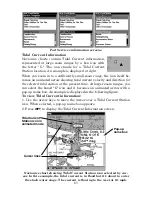
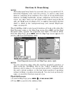
Your GlobalMap 3200 can display Navionics
electronic charts on
MMCs. They work just like a MapCreate custom map on an MMC.
Left, entrance to Chesapeake Bay in a MapCreate 6 custom map, 10
mile zoom. Center, same position on Navionics chart at 11.15 mile zoom
and right, 5.56 mile zoom.
To display a Navionics chart:
1. Install the Navionics MMC in the memory card compartment and
turn on the unit. (For full card install instructions, see Sec. 2.)
WARNING:
You should never format the MMC containing your
Navionics chart. Formatting the MMC will permanently
erase the chart from the card.
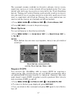
2. From the Map Page, press
MENU
|
↓
to
M
AP
D
ATA
|
ENT
|
↓
to
M
AP
C
HOICE
|
ENT
. Use
↑
or
↓
to select the
Map Name
, then press
ENT
|
EXIT
|
EXIT
.
These figures show menu sequence (from left to right) for selecting a
Navionics chart for the South Chesapeake Bay area.
3. To turn off a Navionics chart, From the Map Page, press
MENU
|
↓
to
M
AP
D
ATA
|
ENT
|
↓
to
M
AP
C
HOICE
|
ENT
. Use
↑
or
↓
to select
L
OWRANCE
, then
press
ENT
|
EXIT
|
EXIT
.
Summary of Contents for GlobalMap 3200
Page 1: ...Pub 988 0105 981 www lowrance com GlobalMap 3200 Mapping GPS Receiver Operation Instructions ...
Page 16: ...10 Notes ...
Page 58: ...52 Notes ...
Page 72: ...66 Notes ...
Page 120: ...114 Notes ...
Page 121: ...115 Notes ...
Page 122: ...116 Notes ...


