
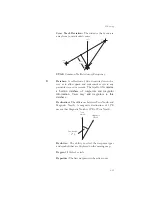
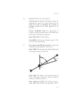


Tae). A letter is shown next to the Track Angle Error
value showing the direction of error in reference to
the current Track.
True North: Geographic north, at the earth’s north
pole.
Tower (TWR): Airport tower communication
frequency.
U
UNICOM: The radio frequencies assigned to
aeronautical advisory stations for communication
with aircraft. Unicoms may provide such airport
information as active runway, wind direction and
velocity and other conditions of importance to pilots.
UTC (Universal Time Coordinate): Greenwich
Mean Time, or the time at the Prime Meridian in
Greenwich, England. Also referred to as Zulu time.
UTC Differential: The difference in time between
that at the present position and UTC.
UTM (Universal Transverse Mercator map
projection system): Also known as Military Grid
Coordinates, the UTM grid consists of 60
north-south/east-west zones, each six degrees wide in
longitude.
V
VFR: Visual Flight Rules.
VOR: Very High Frequency Omni-directional range.
A navigational aid that transmits signals such that a
receiver can indicate its current radial or bearing from
the transmitter.
VHF: Very High Frequency. The range of
frequencies between 30 and 300 MHz.
VNAV: Vertical Navigation.
See Altitude Assist.
W
Waypoint: A navigation fix used in area navigation
and defined by latitude and longitude coordinates.
274
Glossary
Summary of Contents for Apollo GX 50
Page 1: ......
Page 17: ...I 270 K 270 L 270 M 270 N 271 O 272 P 272 R 272 S 273 T 273 U 274 V 274 W 274 xv ...
Page 18: ...xvi ...
Page 88: ...Notes 70 Moving Map Functions ...


