2
5
MENU
■
VIDEO MENU
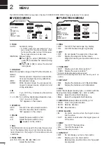
VIDEO MENU
D.RANGE
IR
STRETCH
PULSE
SEA
TRAIL TIME
ON
1
2
MANUAL
AUTO
MID.
WIDE
OFF
OFF
SP
6S
3M
15S
6M
30S
15M
1M
TUNE
1
2
3
4
NAR.
LP
D
TUNE
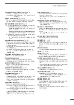
• AUTO: Automatic tuning.
• “A.TUNE” appears for approximately 2 sec
-
onds, instead of the screen display, when
first transmitting after turning ON the power.
The unit also retunes in some cases.
• MANUAL: Manual tuning.
q
Push [
u
] to select [MANUAL], then
push [
q
] to activate the manual tuning
slider.
w
Push [
t
] or [
u
] to adjust the desired
tuning level.
D
D.RANGE
Select the dynamic range of the PPI (Plan Position In-
dicator).
• NAR.: Narrow dynamic range. Even weak reflec
-
tions are displayed as strong reflections.
• MID.: Mid dynamic range.
• WIDE: Wide dynamic range. You can easily dis
-
tinguish between weak reflections and
strong reflections.
D
IR
• OFF: Turn OFF the Interference Reduction
function.
•
1 or 2 (ON): Turn ON the Interference Reduction func-
tion 1 (Low) or 2 (High).
“IR” appears on the screen.
D
STRETCH
• OFF: Turn OFF the echo stretch function.
• ON: Turn ON the echo stretch function.
“ES” appears on the screen.
D
PULSE
• SP: Select the pulse width to short.
• LP: Select the pulse width to long.
“ ” appears on the screen.
D
SEA
• The SEA knob can be used to fine tune the sea clut
-
ter of the display after one of our main levels are se-
lected based on the height of the antenna and sea
conditions.
D
TRAIL TIME
• 6S, 15S, 30S, 1M, 3M, 6M, 15M or
∞
:
Select the trail time.
■
FUNCTION MENU
FUNCTION MENU
POSN DISP
WPT
ON
DIST UNIT
BRG
DIRECTION
ZONE ALARM
BEEP
MAG
PT/SB
KM
OUT
ON
OFF
CURS
NM
TRUE
TRUE
IN
RING
OFF
ON
OWN VECT
ON
OFF
SHIP
360
˚
R
OFF
D
RING
• OFF: Turn OFF the fixed range ring display.
• ON: Turn ON the fixed range ring display.
D
WPT
• OFF: Do not display the waypoint on the screen.
• ON: Display the waypoint on the screen.
Waypoint, bearing and position data are re-
quired.
D
POSN DISP
• SHIP: Display your own ship’s position.*
1
• CURS: Display the cursor position.*
2
*
1
External latitude/longitude data required.
*
2
External latitude/longitude data and bearing data re-
quired.
D
DIST UNIT
• NM: Display the distance unit in Nautical Miles.
• KM: Display the distance unit in Kilometers.
D
BRG
Select the displayed bearing type, no relation with the
bearing data format (NMEA, N+1, AUX or GPS).
• TRUE: Select the true North bearing.
• MAG: Select the magnetic North bearing.
D
DIRECTION
(except HDG and CSE) (p. 15)
• TRUE: True or magnetic direction.
• 360°R: Relative direction
• PT/SB: Bow direction
D
ZONE ALARM
• IN: An alarm sounds when the target comes
into the zone.
• OUT: An alarm sounds when the target goes out
of the zone.
D
BEEP
• OFF: Turn OFF* the beep tone.
• ON: Turn ON the beep tone.
* Except for the alarm function.
D
OWN VECT
• OFF: Do not display your own ship’s vector.
• ON:
Display your own ship’s vector.
Bearing data, position data and ship speed
are required.
The SERVICE MAN MENU is described in ‘Section 10 SERVICE MAN MENU.’ Please see Section 10 for details.

