5-18
Rev 2
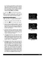
Figure 5-67
| HICUP
|REF: RSW
|RAD: 182.7^
|DIS: 7.0nm
|N 26^24.80'
|W 81^46.65'
INT
5.4.2 Creating A VOR User Waypoint
A user-defined VOR waypoint must contain an identifier,
magnetic variation, latitude, and longitude. The mag-
netic variation may be manually entered or, if one is not
entered, one will automatically be calculated and stored.
In addition, a VOR frequency may be stored. The pro-
cedure for creating a VOR user waypoint is similar to
that just described for creating an airport user waypoint.
Begin by selecting the VOR type waypoints instead of
the airport type waypoints. The VOR identifier can be
one to three characters in length. A VOR user waypoint
page that has not yet been defined by the user contains
the user identifier at the top of the page and three lines
of dashes (figure 5-63). The top line of dashes may be
filled in with frequency and magnetic variation. The sec-
ond line is for latitude and the third line is for longitude
(figure 5-64). A user-defined VOR is stored as an
“undefined” (U) class.
5.4.3 Creating An NDB User Waypoint
A user-defined NDB waypoint must contain an identifier,
latitude, and longitude. In addition, an NDB frequency
may be stored. The procedure for creating an NDB user
waypoint is similar to that described for creating an air-
port user waypoint. Begin by selecting the NDB type
waypoints instead of the airport type waypoints. The
NDB identifier can be one to three characters in length.
An NDB user waypoint page that has not yet been
defined by the user contains the user identifier at the top
of the page and three lines of dashes (figure 5-65). The
top line of dashes may be filled in with the NDB fre-
quency. The second line is for latitude and the third line
is for longitude (figure 5-66).
5.4.4 Creating Intersection Or Supplemental User
Waypoints
A user defined intersection or supplemental waypoint
must contain an identifier, latitude, and longitude. The
identifier for either can be one to five characters in
length. There are two procedures which may be used to
define these waypoints. Both procedures begin by
selecting the INT or SUP type waypoints, as appropri-
ate.
The first method is similar to that described for creating
an airport, VOR, or NDB user waypoint. Only a latitude
and longitude need be entered to complete creating the
waypoint.
The second method is to define the waypoint’s position
in terms of a radial and distance from any other pub-
lished or previously defined user waypoint. To create a
user waypoint in this manner:
1. Use the right outer knob to select INT or SUP type
waypoints, as appropriate (figure 5-67).
Figure 5-63
| AAA
|
| U
|!!!.!! !!^!
|
! !!^!!.!!
'
|!!!!^!!.!!'
CRSR
Figure 5-64
| AAA
|
| U
|113.00 9^E
|N 42^46.04'
|W100^22.33'
VOR
Figure 5-65
| ND1
|
|
|FREQ !!!!.!
|
! !!^!!.!!
'
|!!!!^!!.!!'
CRSR
Figure 5-66
| ND1
|
|
|FREQ 328.0
|N 33^40.67'
|W 90^04.59'
NDB
Summary of Contents for KLN 900s
Page 1: ...Pilot s Guide KLN 900 Global Positioning System ORS 01 02 and 04 ...
Page 3: ...ii Rev 2 THIS PAGE INTENTIONALLY LEFT BLANK ...
Page 57: ...3 30 Rev 2 THIS PAGE INTENTIONALLY LEFT BLANK ...
Page 89: ...3 62 Rev 2 THIS PAGE INTENTIONALLY LEFT BLANK ...
Page 103: ...4 14 Rev 2 THIS PAGE INTENTIONALLY LEFT BLANK ...
Page 132: ...5 25 Rev 2 THIS PAGE INTENTIONALLY LEFT BLANK ...
Page 157: ...5 50 Rev 2 THIS PAGE INTENTIONALLY LEFT BLANK ...
Page 170: ...6 13 Rev 2 THIS PAGE INTENTIONALLY LEFT BLANK ...
Page 189: ...8 4 Rev 2 THIS PAGE INTENTIONALLY LEFT BLANK ...
Page 191: ...9 2 Rev 2 THIS PAGE INTENTIONALLY LEFT BLANK ...
Page 193: ...Rev 2 THIS PAGE INTENTIONALLY LEFT BLANK A 2 ...
Page 201: ...Rev 2 THIS PAGE INTENTIONALLY LEFT BLANK B 8 ...
Page 213: ...Rev 2 THIS PAGE INTENTIONALLY LEFT BLANK E 2 ...
Page 223: ...Rev 2 I 6 THIS PAGE INTENTIONALLY LEFT BLANK ...


