Geophysical Survey Systems, Inc.
SIR® 20
Manual
MN92-078 Rev F
17
4
This window provides you with a choice of the three ways you can collect radar data. We will discuss
Free Run and Point Mode later, but for now click the Survey Wheel button.
•
Notice the button for Enable GPS. You can collect GPS data along with your survey wheel, free
run, or point data. See the section on using a GPS for details on setup.
•
After you click Survey Wheel, you should see a button for Calibrate SW. Click on it.
5
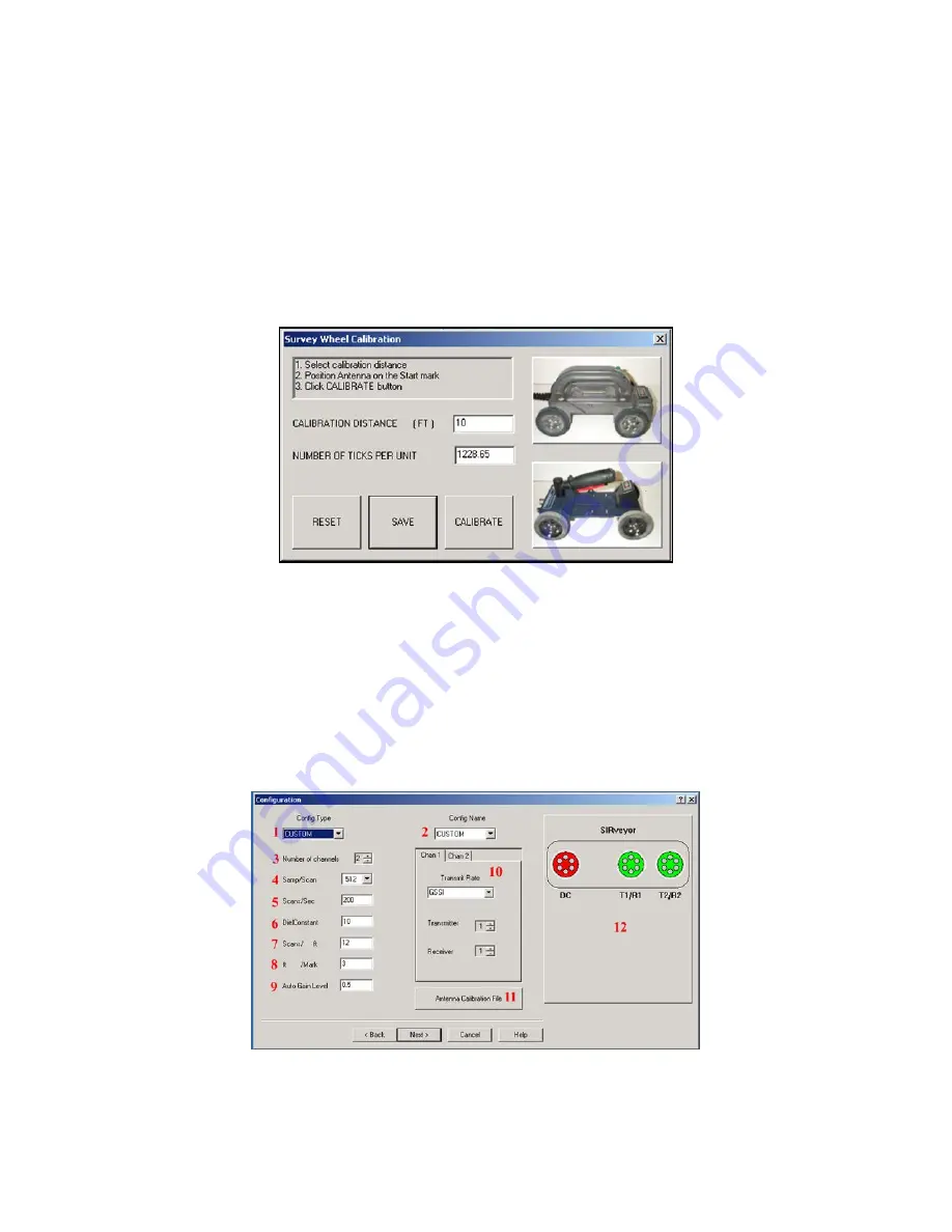
You will see a window pop up with the heading Survey Wheel Calibration (Figure 13). This is where
you enable the specific survey wheel device you are using with the SIR 20 and determine how many
internal ‘ticks’ per selected unit of distance.
Figure 13: Survey Wheel Calibration dialog box.
•
If you have a StructureScan minicart, click on the image of the cart that you have.
•
If you have an Optical cart, click the image of the blue minicart.
•
If you have a different survey wheel device than the ones pictured, then you must calibrate your
survey wheel.
•
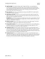
Once calibrated, click Save > Next >. This will open a window with the heading
Configuration
(Figure 14)
.
You must calibrate your survey wheel.
Failure to do so will result in an incorrect
horizontal scale on your profiles.
Figure 14: Configuration window.
Summary of Contents for SIR 20
Page 1: ......
Page 4: ......
Page 6: ......
Page 12: ...Geophysical Survey Systems Inc SIR 20 Manual MN92 078 Rev F 6 ...
Page 56: ...Geophysical Survey Systems Inc SIR 20 Manual MN92 078 Rev F 50 ...
Page 88: ...Geophysical Survey Systems Inc SIR 20 Manual MN92 078 Rev F 82 ...
Page 96: ...Geophysical Survey Systems Inc SIR 20 Manual MN92 078 Rev F 90 ...


