


0
Reference
Creating Waypoints
Creating and Using Waypoints
The Garmin GPSMAP 172/172C stores up to 3000 alphanumeric waypoints with a user-defined
icon, comments, depth, and water temperature available for each waypoint. Waypoints can be created
using three basic methods:
•
ENTER/MARK
key– used primarily for marking your present position, the
ENTER/MARK
key
also provides options that allow you to select a map position or map item from the map display.
• Graphically– allows you to define a new waypoint position from the map display using the
ARROW KEYPAD
.
• Text Entry– allows you to enter a new waypoint’s coordinates manually (from a chart, etc.).
Marking Your Present Position
The Garmin GPSMAP 172/172C’s
ENTER/MARK
key lets you quickly capture your present posi-
tion (or cursor or map item position) in order to create a new waypoint. You must have a valid position
(2D or 3D) fix to mark your present position. This can be determined by looking at the GPS tab on the
Main Menu.
To mark your present position:
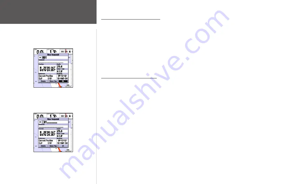
1. Press and hold the
ENTER/MARK
key until the ‘New Waypoint’ window appears, then release it.
You see a default three-digit name and symbol for the new waypoint.
2. To accept the waypoint with the default name and symbol, press
ENTER
to confirm the highlighted
‘OK’ prompt.
3. To enter a different name, highlight the name field and press
ENTER
, then use the
ARROW
KEYPAD
to enter the new letters/numbers and press
ENTER
when done. You may use up to 10
alphanumeric characters for the name.
4. To enter a different symbol, highlight the symbol field to the left of the name and press
ENTER
,
then use the
ARROW KEYPAD
to highlight the new symbol and press
ENTER
.
5. To enter optional comments, depth, or water temp, highlight the appropriate field and press
ENTER
, then use the
ARROW KEYPAD
to enter a value and press
ENTER
.
Highlight ‘OK’ and press
ENTER
to
use the default name and symbol.
Highlight a field and press
ENTER
to enter a new symbol, name, com-
ment or depth.
Summary of Contents for GPSMAP 172
Page 1: ...owner s manual GPSMAP 172 172C chartplotting receiver ...
Page 108: ......
Page 109: ......


