background image


NRI Grazing Land On-Site Data Collection  

(03/23/20011)  B-1 


Appendix B  
The Garmin GPS Map 76 Receiver:  Features, Functions, 
Setup, and Quality of Position 


Garmin GPS Map76 Features 

Specifications 


Weight: 7.5 ounces 


No. channels: 12 parallel 


Antenna type: Quad Helix 


Display size: 180 x 240 pixels 


Included map base:  North America major highways, cities, exits – 

accepts optional 

Map Source ™ enhanced maps


No. Waypoints: 500 with name and graphical symbol 


No. Tracks: 10 saved, about 10,000 total track points, auto logging 


No. Routes: 50 comprised of 50 waypoints each 


Rugged standard: IPX 7 waterproof – 

floats on surface!


Other features: Trip computer, tidal info, sun/moon info, hunting/fishing info 


Manual, pg. 4 and: http://www.garmin.com/products/gpsmap76/spec.html. 


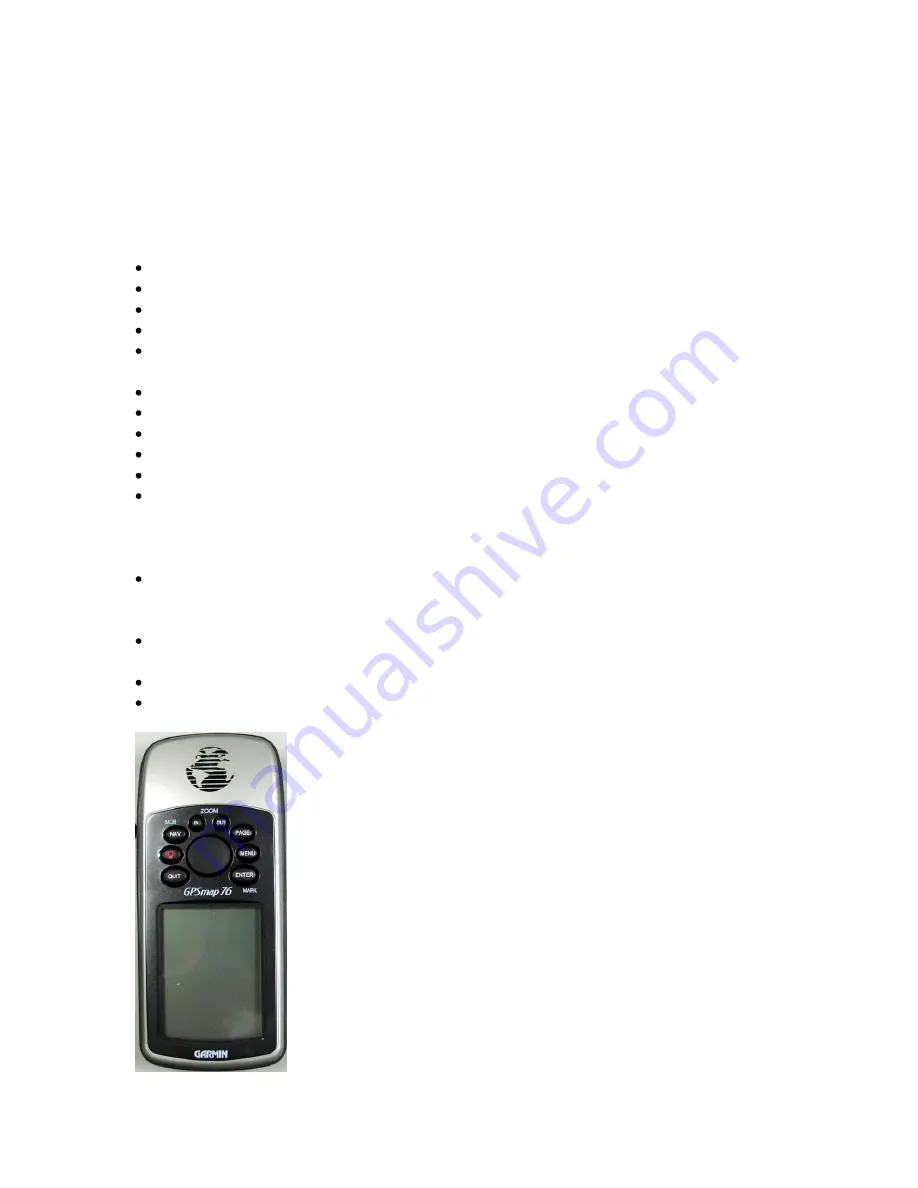
GPS Map 76 – Front View 

Visible on the front side of the Map76 is the: 


Antenna – always hold the receiver upright with the display facing you and the 
antenna at about an 80 degree angle from horizontal. Face towards the southwest to 
obtain the best GPS reception. 


Screen protector – Provides international patent information and a reminder of how to 
orient the receiver for best GPS satellite reception. 


Keypad – A ROCKER key surrounded by 8 functional keys. 


Display – Display capable of depicting GPS data and 4 grey color maps. 


Summary of Contents for GPS Map 76

Page 1: ...of 50 waypoints each Rugged standard IPX 7 waterproof floats on surface Other features Trip computer tidal info sun moon info hunting fishing info Manual pg 4 and http www garmin com products gpsmap76 spec html GPS Map 76 Front View Visible on the front side of the Map76 is the Antenna always hold the receiver upright with the display facing you and the antenna at about an 80 degree angle from hor...

Page 2: ...ction 03 23 20011 B 2 GPS Map 76 Back View On the back side of the Map 76 you will find 1 The antenna port 2 The battery compartment and 3 The power data port You can connect an external antenna with an MCX connector to the antenna port ...

Page 3: ...ry compartment is found in the middle of the receiver Lift twist and pull the D ring to remove the flap covering both the battery compartment and the power data port Be sure batteries are oriented according to the guides etched on the inside of the compartment Use two fresh AA batteries from the same pack each time you change batteries The power data port is located near the bottom of the back sid...

Page 4: ...ce to access the main menu Press once to display page option menus ENTER Press this key to activate a data field or confirm a selection Press and hold to capture a waypoint ROCKER Use this key to move between fields and between field place holders within fields The ROCKER key moves left right up and down ROCKER Key The ROCKER key is used to move from scroll up and down lists in menus It is also us...

Page 5: ...Press the POWER key a second time to adjust backlight and display contrast Warning turning on the backlight drains the battery Warning Do not change the contrast Doing so may cause display loss and force a system reset Use the ROCKER key to adjust the sliders for backlight Use the QUIT key to accept the setting or exit the adjustment Other setups affect how long the backlight stays on POWER Key Tu...

Page 6: ...ange to have North in same direction as track New Elevation Enter a better elevation to improve 3D performance New Location Select this option if the receiver has been moved more than 100 miles Choose the Automatic option to have the receiver search the sky for satellites or select Use Map to help it figure out where in the world it is The Use Map option allows you to move the pointer on the Map p...

Page 7: ...een stopped Uses last navigation setting point route and track NAV Key Second Press Press the NAV key a second time to set a Man Overboard MOB point The MOB once set allows the Map76 to provide navigation directions back to that spot A good example is setting the location of a vehicle prior to entering thick woods then navigating back to the vehicle See Manual Pg 10 ENTER Key Press the ENTER key t...

Page 8: ...position based on 4 or more satellites o 2D 3D differential location computing positions using WAAS or other differential corrections o Simulating GPS the receiver is running in simulator mode and is not receiving GPS signals Satellite sky view shows location of satellites in sky relative to location in center of receiver Satellites being tracked are plotted Satellite strength indicators bars disp...

Page 9: ...in com cartography mapsource Change the zoom scale by using the zoom keys on the Map76 keypad o ZOOM IN o ZOOM OUT A scale bar is displayed in the lower left corner of the map If Overzoom is displayed under the scale no further map information is available Map Page Zoom In Out Use the ZOOM IN key to zoom in on the map display Note the scale change in the lower left corner of the map Use the ZOOM O...

Page 10: ...st pops up Use the ROCKER key to move up down the list When the option desired is highlighted in this case Small 1 Row then press the ENTER key The map display changes to conform to your selection See Manual pg 27 Map Page Options Change Data Fields While on the map page press the MENU key A choice list pops up Scroll to Change Data Fields Once highlighted press the ENTER key ...

Page 11: ...ata field highlighted Press the ENTER key to change the type of data displayed in the field Use the ROCKER key to scroll up down the choice list that pops up When the desired data type is highlighted press the ENTER key Use the ROCKER key to scroll to a different data field See Manual pg 27 ...

Page 12: ...line As you change direction the pointer will always point toward the active navigation waypoint When you are going directly toward the active waypoint the pointer is aligned with the vertical line in the compass ring When you arrive at the waypoint an Arriving at Destination message will be displayed The compass ring is not a true compass you must be moving for the pointer and compass ring to wor...

Page 13: ... is point to point and follows a list that the user designates When we choose a list of waypoints a name will be assigned in the top field Each waypoint chosen is displayed Immediately to the right of the waypoint is a data field The data field provides real time status to the route navigator Status fields include Distance Course and ETA A route distance total is displayed in the lower right field...

Page 14: ...e Press and hold the POWER key until the first screen appears Press the ENTER key until the GPS Info Page appears Press the MENU key and then use the ROCKER key to scroll to Start Simulator Press the ENTER key to start simulator The Status Bar will read SIMULATOR Main Menu The Main Menu Page contains settings not found on the Main pages It can be accessed from any page by pressing the MENU key twi...

Page 15: ... know how full an external battery is by looking at this icon See Manual Pg 37 Accessing the Setup Menu Scroll down the Menu page until Setup is highlighted then press the ENTER key You will be taken to the first setup tab Making changes to settings Use the ROCKER key to move to an option field then press the ENTER key to access the options for that field Use the ROCKER key to scroll through choic...

Page 16: ...or at 24 000 miles out so they will be low on the horizon You must have an unobstructed view of the sky no canopy no buildings for the Map76 to utilize WAAS If you want to use WAAS you should do the following to further optimize reception If you are in the Western U S then face due south hold the receiver with your arm outstretched and raise the position of the receiver until it is 45 to 65 from h...

Page 17: ...o lock in the choice Although annoying beginners will find it s easier to know and see what s going on with the receiver if the beeper is left fully on Time Tab Options The Time tab has options for setting Time Format Time Zone Daylight Savings Time Current Date and Current Time Use the ROCKER key to moved to an option field then press the ENTER key to access the options for that field Time Format...

Page 18: ...ht Savings Time field Use the ROCKER key to scroll through a choice of Auto Yes or No Auto uses the GPS calendar to determine DST for a given location in the U S If Yes is chosen then DST is displayed for the location If No is chosen then DST is not displayed If Time Zone Other is chosen then DST will not be displayed at all Current Date field Determined from the GPS signal from space and is not a...

Page 19: ...outputs National Marine Electronic Association NMEA sentences Not relevant to most NRCS activities Distance and Speed Choose from Nautical Statute English or Meters This setting will be used in all data fields relating to speed or distance Temperature Choose from Fahrenheit English or Celsius Metric degrees The Map76 accepts NMEA formatted temperature data from over the side instruments Not really...

Page 20: ...erage the speed and heading at the rate specified in the time seconds setting The receiver provides faster updates of PVT when the speed filter is set lower See Manual Pg 58 Location Tab Options Location tab contains the settings for Location Format Map Datum North Reference and Magnetic Variation The settings are used in related data fields throughout the receiver ...

Page 21: ...type of spherical coordinate State Plane coordinates are not available Map Datum Choose from one of 100 datums available Geodetic datums define the size and shape of the earth and the origin and orientation of the coordinate systems used to map the earth For NRCS work choose the GPS standard WGS 84 NRCS DOQs use NAD 83 as the horizontal datum Set to NAD 83 for navigation to points generated from N...

Page 22: ...gnetic Variation must be updated periodically when using this setting For NRCS work either Magnetic or Grid north references are most commonly used Magnetic Variation The difference between true north and magnetic north There is a difference between magnetic and true north that varies with latitude and longitude The difference is commonly known as declination but Garmin refers to it as variation V...

Page 23: ...rther information consult the Manual Pg 60 Anchor Drag Provides an alarm when the boat moves more than the distance setting Not useful for most NRCS activities Approach and Arrival Alerts you when you are approaching a turn such as in a route of multiple waypoints or arriving at your destination Automatic Alerts you between 15 and 90 seconds before you arrive based on your speed of approach Distan...

Page 24: ...seful for most NRCS activities Deep Water Not useful for most NRCS activities Manual Pg 60 Interface Tab Options Press the right ROCKER key to move to the Interface tab The Interface tab contains settings for one field initially Serial Data Format The field contains eight settings that let the Map76 communicate with computers and other compliant devices Garmin The Map76 can communicate with Garmin...

Page 25: ...nit is held with the top pointed towards the horizon or upside down satellite reception will be severely degraded Try to face the most open part of the sky If southwest is open face in that direction Hold the receiver at eye level or higher to obtain best reception Hold the receiver with your arm fully stretched out Use an external antenna Garmin GA 27C and a back pack whenever possible Initializi...

Page 26: ...ill be displayed if the Map76 is unable to determine its location Select an option depending on the situation to help the unit acquire satellites The most efficient option is New Location ROCKER to New Location then press ENTER The GPS Information Page Displays speed elevation accuracy receiver status satellite status date time and location When the receiver receives 3 satellite signals it will re...

Page 27: ...UTM and degrees minutes seconds by toggling the ROCKER key up down Using the GPS Information Page to determine quality of position Quality of Position refers to how well your receiver is computing positions at your particular location The quality of position depends on several variables being optimal Ionospheric interference is below modeled tolerances There is minimal multipathing reflectance of ...

Page 28: ...ement a rock field or next to a rocky bluff or cliff If so you are in a multipathing environment and the GPS receiver is receiving the same signal from several different directions Try using a ground plane a metal disk that mounts on top of the antenna bar Its diameter should be a little bit larger than the external antenna If you are trying to navigate to a point located in a high multipathing ar...

Reviews: