


Managing blocks
Select a block in the list and toggle the buttons above the list to change the attributes of the block:
Icon shown...
Sets the...
/
/
Block and flight lines to visible/ block only to visible / block and flight lines to
hidden
/
Block to editable / locked (not editable)
/
Flight lines to follow the wind direction / to be manually manipulated
/
Color of the flight lines to light / dark
Click
next to the block to move blocks up and down the list. Blocks at the top of the list appear as the
top-most blocks on the map.
To copy a block, select the block in the list or on the map and then click
below the list. Copying a block is
useful if you need to scan the same area using different GSD and overlap values.
To remove a block that is no longer required, select the block and then click
.
To rename a block, select the block in the list and then click on the block's name. You can now edit the
name.
A block can have the following status:
l
No icon: Not flown
l
Successfully mapped, log files downloaded and settings frozen
l
Not successfully mapped and settings frozen
l
Flown and waiting for post-flight checklist to be completed to determine if the block was
successfully mapped. Settings are frozen.
Note –
Blocks with the status icon
,
or
cannot be renamed, changed, or removed. However, you
can copy the block and then edit the copy.
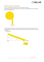
GSD and height
The
GSD
(ground sample distance) field specifies the distance on the ground represented by each pixel.
The smaller the value in the
GSD
field, the more detailed the images. You should always specify a value
equal to or smaller than the resolution required in the final orthophotos, after the images are processed. If
the value in the
GSD
field is larger than the final resolution required, then the images acquired during the
flight will not be detailed enough and the image processing software will need to interpolate additional
pixels. This will result in images that do not have the expected resolution.
The
GSD
field and the height at which the rover flies are linked. The higher the rover flies, the larger the
distance on the ground represented by each pixel in the images acquired during the flight.
The default resolution for the UX5 HP aerial imaging solution is 3.2 cm (1.3 ") when using the 15 mm lens,
2.0 cm (0.8 ") when using the 25 mm lens, and 1.3 cm (0.5 ") when using the 35 mm lens.
31
Delair-Tech
|
676, Rue Max Planck – 31670 Toulouse-Labège, France
|
Tel: +33 (0) 5 82 95 44 06
|
Capital: 238 110,30 € - APE: 3030Z – Intra-Community VAT number: FR90 53 09 69 781 – 530 969 781 R.C.S. Toulouse
This document is the sole property of Delair-Tech and cannot be used or reproduced without the written authorization of Delair-Tech
.


