


75
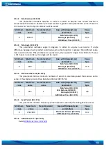
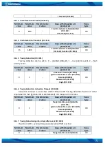
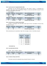
9.6.33
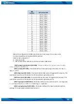
Geofence Zone #1 Longitude (X2) (ID=1035)
Parameter has two meanings depending on zone shape. If shape is a rectangle, then
ID=1035 is right upper corner X coordinate. If shape is a circle, then ID=1035 is radius of circle
with center of ID=1033 and ID=1034.
For rectangle:
Minimum
value
Maximum
value
Recommended
value
Goes with (depends on)
parameters
Value
type
-180
180
-
All Geofencing parameters
Float
For circle:
Minimum
value
Maximum
value
Recommend
ed value
Goes with (depends on)
parameters
Value
type
0
1000000
1000
All Geofencing parameters
Float
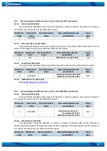
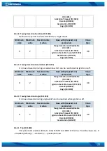
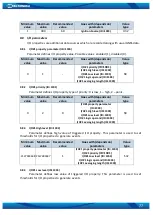
9.6.34
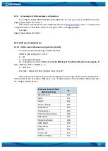
Geofence Zone #1 Latitude (Y2) (ID=1036)
If shape is rectangular, then ID=1036 is right upper corner Y coordinate. If shape circle,
ID=1036 is not used.
Minimum
value
Maximum
value
Recommended
value
Goes with (depends on)
parameters
Value
type
-90
90
-
All Geofencing parameters
Float
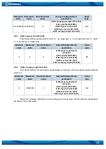
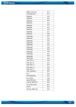
Other 4 GeoFence zone’s parameters have the same logic as shown in GeoFence Zone #1.
GeoFence
Zone
Number
Geofence
Zone’s
parameters
1
1030-1036
2
1040-1046
3
1050-1056
4
1060-1066
5
1070-1076
AutoGeofencing
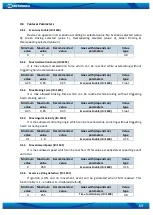
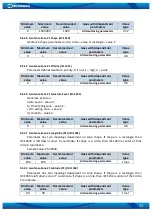
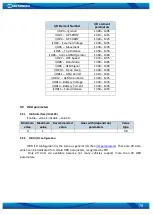
9.6.35
Enable/Disable (ID=1101)
Enable
–
value 1; disable
–
value 0.
Minimum
value
Maximum
value
Recommended
value
Goes with (depends on)
parameters
Value
type
0
1
1
U8
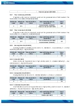
9.6.36
Activation Timeout (ID=1102)
Parameter represents AutoGeofencing activation timeout in seconds.