CPN700i and CPN1010i Multimedia Chart Plotters
Page 91
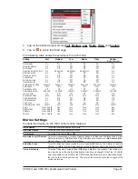
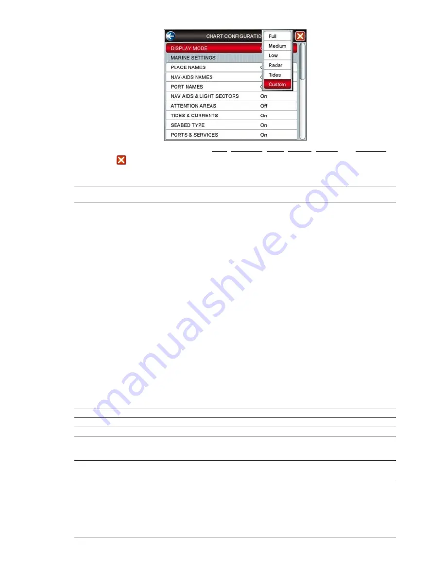
4. Tap on the desired preset among
Full
,
Medium
,
Low
,
Radar
,
Tides
and
Custom
.
5. Tap on
to exit to the Chart page.
The following table shows the selections for each mode:
Setting
Full
Medium
Low
Radar
Tides
Custom
(Default values)
Place Names
On
On
On
On
On
On
Nav-Aids Names
On
Off
Off
Off
Off
Off
Port Names
On
Off
Off
Off
Off
Off
Nav-Aids & Light Sectors
On
No Sectors
No Sectors
No Sectors
Off
On
Attention Areas
On
On
Off
Off
Off
On
Tides & Currents
On
Off
Off
Off
On
On
Seabed Type
On
Off
Off
Off
Off
On
Ports & Services
On
On
Off
On
Off
On
Tracks & Routes
On
Off
Off
Off
Off
On
Depth Shading Mode
Dynamic
Dynamic
Dynamic
Dynamic
Dynamic
Dynamic
Safe Depth
15ft
15ft
15ft
15ft
15ft
15ft
Depth Range Min
0ft
0ft
0ft
0ft
0ft
0ft
Depth Range Max
32804ft
32804ft
32804ft
32804ft
32804ft
32804ft
Lat/Lon Grid
On
Off
Off
Off
Off
Off
Boundaries Mode
Auto
Auto
Auto
Auto
Auto
Auto
Chart Boundaries
On
Off
Off
Off
Off
Off
VAD Boundaries
On
Off
Off
Off
On
Off
Chart Lock
On
On
On
On
On
On
Underwater Ob. Limit
1000ft
32ft
32ft
32ft
32ft
1000ft
Rocks
Icon + Depth
Icon
Icon
Icon
Icon
Icon
Obstructions
Icon + Depth
Icon
Icon
Icon
Icon
Icon
Diffusers
Icon + Depth
Icon
Icon
Icon
Icon
Icon
Wrecks
Icon + Depth
Icon
Icon
Icon
Icon
Icon
Marine Settings
Controls the display on the chart of the marine features.
Place Names
: Turns the local area names
On
or
Off
.
Nav-Aids Names
: Turns the Nav-Aids names
On
or
Off
.
Port Names
: Turns the Port names
On
or
Off
.
Nav-Aids & Light Sectors
: Turns the presentation of Lights, Signals, Buoys and Beacons
On
(Nav-Aids & Light
Sectors are shown),
Off
(Nav-Aids & Light Sectors are not shown) or
No Sectors
(Nav-
Aids are shown, Light Sectors are hidden).
Attention Areas
: Turns the Attention Areas (areas in which special attention by the mariner is required
because of natural or man-made hazards sailing regulations and restrictions)
On
or
Off
.
Tides & Currents
: Turns the Tides and Currents
On
or
Off
. When data/time is available, Tidal stream ar-
rows are shown on the charts, indicating the direction and strength of the Tide. If no data/
time is available from the GPS or the
CPN Series Chart Plotter is not in Simulation Mode,
the icon on the chart is generic one. The color of the arrow denotes the strength of the
current as follows:
Содержание CPN1010i
Страница 1: ......
Страница 144: ...CPN700i and CPN1010i Multimedia Chart Plotters Page 145 ...
Страница 156: ...CPN700i and CPN1010i Multimedia Chart Plotters Page 157 ...
Страница 159: ...Page 160 Owner s Manual ...
Страница 163: ...Page 164 Owner s Manual 7 1 7 OPTIONAL FF525 BLACK BOX FISH FINDER ...
Страница 188: ......


