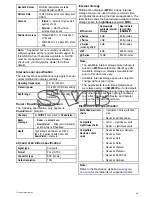
Geodetic Datum
WGS-84 (alternatives available
through Raymarine MFD)
Refresh Rate
10 Hz (10 times per second Concurrent
GNSS)
Antenna
•
Internal
— Ceramic chip mounted
near top of unit
•
External
— GA150 external
antenna may be used
Position Accuracy
• Without SBAS: <= 15 metres 95%
of the time
• With SBAS: <= 5 metres 95% of the
time
Note:
* Supported but not currently available. A
software update will be required to add support for
this GNSS when it becomes available. A GA150
must be connected to receive Beidou. Please
check with your Raymarine dealer for further
details.
Internal sonar specification
The internal sonar specifications only apply to sonar
variant multifunction display variants.
Operating frequencies
50 / 83 / 200 KHz
Transmit power
Up to 600 W RMS, depending
on transducer
Depth range
Up to 3000 ft, depending on
transducer
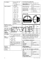
Sonar / DownVision
™
specification
The following specification only applies to
DownVision
™
products.
Channels
2 x
CHIRP
(1 x sonar and 1 x
DownVision
™
)
Beam
coverage
•
Sonar
—
conical
beam.
•
DownVision
™
— Wide (port / starboard)
and thin (fore / aft)
fan
beam.
Depth
Typical depth performance of 183 m
(600 ft). Applies to both Sonar and
DownVision
™
channels.
a9x and a12x Video specification
Signal type
Composite
Format
PAL or NTSC
Connector type
BNC (female)
Output resolution
720p
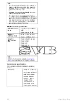
Internal storage
Multifunction displays (
MFD
s) include internal
storage that can be used to store recorded video
and photos taken using the Camera application. The
table below shows the approximate available internal
storage space for
LightHouse
powered
MFD
s.
MFD variant
Approximate
available internal
storage
Approximate
record time
(CAM200IP)
a Series
2 GB
88.8 minutes
c Series
2 GB
88.8 minutes
e Series
(excluding
e165
)
2 GB
88.8 minutes
e165
6 GB
266.6 minutes
gS Series
14 GB
622.2 minutes
Note:
• The available internal storage stated above is
based on
MFD
manufactured after May 2014.
Available storage on displays manufactured
prior to this date may vary.
• Available internal storage space is subject to
change without prior notice.
• The approximate record times stated above
were taken using a
CAM200IP
set to its default
resolution of 720p. Increasing image resolution
and other factors such as lighting conditions
may affect the resulting filesize and therefor
reduce the available record time.
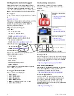
Electronic chart specification
Embedded electronic
charts
• LightHouse Charts world base
map.
• Navionics world base map.
Compatible
LightHouse charts
• Vector — LightHouse charts
• Raster — LightHouse charts
Compatible
Navionics chart
cards
• Navionics Ready to Navigate
• Navionics Silver
• Navionics Gold
• Navionics Gold+
• Navionics Platinum
• Navionics P
• Navionics Fish'N Chip
• Navionics Hotmaps
Note:
Refer to the Raymarine website (
www.rayma-
rine.com
) for the latest list of supported charts.
Technical specification
427
Содержание A series
Страница 2: ......
Страница 14: ...14 a Series c Series e Series...
Страница 41: ...13 GPS receiver 14 Thermal camera 15 Wireless connection Planning the installation 41...
Страница 48: ...48 a Series c Series e Series...
Страница 80: ...80 a Series c Series e Series...
Страница 118: ...118 a Series c Series e Series...
Страница 184: ...184 a Series c Series e Series...
Страница 185: ...Chapter 13 Man Overboard MOB Chapter contents 13 1 Man overboard on page 186 Man Overboard MOB 185...
Страница 188: ...188 a Series c Series e Series...
Страница 191: ...Chapter 15 Fuel manager Chapter contents 15 1 Fuel manager overview on page 192 Fuel manager 191...
Страница 206: ...206 a Series c Series e Series...
Страница 228: ...228 a Series c Series e Series...
Страница 290: ...290 a Series c Series e Series...
Страница 310: ...310 a Series c Series e Series...
Страница 340: ...340 a Series c Series e Series...
Страница 374: ...374 a Series c Series e Series...
Страница 422: ...422 a Series c Series e Series...
Страница 436: ...436 a Series c Series e Series...
Страница 462: ...462 a Series c Series e Series...
Страница 463: ......
Страница 464: ...www raymarine com...

