


INTEGRATED CLOUD-BASED
PROCESSING
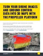
If you’re looking to visualize your drone survey data, we recommend using
AeroPoints together with Propeller’s cloud-based visualization and analysis platform.
(Access to the Propeller Platform is available only with a software license purchase.
Without it, you only have access to the AeroPoints dashboard, where you can
process and export data to use elsewhere.)
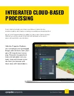
With the Propeller Platform,
you can upload your geotagged
images and 24 hours later you’ll
get a 3D map of your survey
area. Powerful measurement
tools and calculators let you
track, map, and measure your
site from you browser and
share data with stakeholders.
6
AeroPoints User Manual
Содержание AEROPOINTS
Страница 1: ...USER MANUAL...