GUIDANCE
■
Guidance screen
Once you select “Guidance” the guidance screen appears. If you enter a new
destination address it may take some time before the first guidance advice is
shown. The navigation system plans the route. During route planning the
egg-timer appears in the status line.
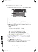
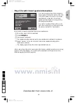
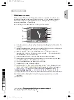
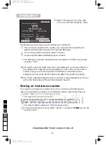
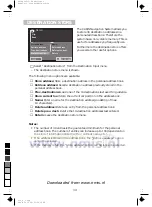
The following information is shown in the guidance screen:
1
Current car position. Road name, city name and village name if stored in the
database.
2
Visual guidance advice. Diagram of the next junction or turning. In addition,
direction changes are announced by voice messages.
3
Shows a preview of the next traffic obstruction on the planned route
(appears only if a RDS TMC radio is connected and if TMC announcements
are available for the planned route)
4
Warning note. You are in an area with limited road information.
5
GPS reception status. As soon as valid position data is received by the GPS
receiver the colour of the satellite icon is green.
6
Turn into street. Road you have to turn into next.
7
Distance to the next direction change *.
8
Options menu: “Menu” (goes to the Main Menu), “Map” (shows the route
map), “Info” (opens the Route Information menu) or “Detour” (opens the
detour menu if an obstruction is ahead; only if a RDS TMC radio is
connected, see page 29.)
9
Target direction arrow. Shows the airline direction to the selected destination.
0
Distance to the destination* (real driving distance as soon as a route is
planned).
q
Status line.
* The measuring units are dependent on the system settings.
See chapter “System Settings”, page 38.
80 m
Menu
Map
Info
Detour
l
)
s
01.09.1998
TMC
145 km
–>
1:08h
✱
w
8
9
7
6
3
4
5
2
1
0
q
BAXTER ST., BIRMINGHAM
GLOUCESTER RD.
1.3 km
d
26 km
GB
25
0
5
25
75
95
100
520_e_5.chp
Thu Nov 12 09:33:52 1998
Farbprofil: Deaktiviert
Komposit Standardbildschirm
Downloaded from www.nmis.nl

