


SymphoniePRO User Manual
Rev. 8
[email protected] | Page 100
11 January 2018
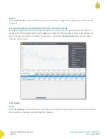
5.2.1 Data Export
Data export controls exporting of data files from the site file into a common text file format that can be easily
processed by third-party data analysis tools or viewed in a text editor. The Export Type defines what type of data
(measurements, logger diagnostic information, logger communication history log, or logger events history log)
are exported when the Export button is clicked.
The start and end dates define the data to be exported by a time range. By default, these are blank, which
provides an easy way to export all data. The start and end dates of exports have a 1 day resolution (rather than
hours, minutes, or seconds).
Details related to data export formats can be found in
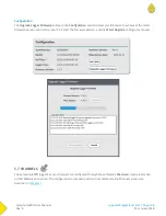
5.2.2 Site
The Site section of the Site Utilities screen describes details about the site’s location (for example, “West Ridge”,
which is a more specific description than the town in which the site is located). The Description field holds up to
20 text characters. The Project field holds up to 20 text characters and can be used for a brief description of the
project (for example, “Windy Wind Farm”). The Tower field describes the type of monitoring tower on which the
instrumentation and sensors are mounted (“NRG 60 m XHD Tubular”, for example). The Tower field appears
only in the SymphoniePRO Desktop Application and does not exist in the logger or in the data set generated by
the logger. The Commission Date is the date the site began collecting data. Data imported before this date will
be filtered out.
Units may be set to SI (metric) units only. The Units setting defines how wind speed data are scaled upon export
or in charts and reports.
5.2.3 Data Import
The Import button allows you to select and import raw data files into the site database.
5.2.4 Location
The Location section of the Site Utilities screen describes the site’s location. The Description field holds up to 20
text characters (for example, “Springfield, Vermont”). The latitude and longitude are entered in decimal degrees
with precision to 7 decimal places. Elevation of the site is entered in meters. The latitude, longitude, and
elevation will update automatically according to the GPS coordinates from the *.RLD files. By checking the Lock
Location check box, coordinates in the *.RLD files can be ignored and will lock the coordinates in the Latitude,
Longitude and Elevation fields instead of automatically updating them.
The time zone of the location is entered relative to UTC with up to ¼ time zone resolution (for locations where
the adjacent time zones are ½ and ¼ hour difference rather than 1 hour).
Содержание SymphoniePRO
Страница 1: ......
Страница 74: ...SymphoniePRO User Manual Rev 8 support nrgsystems com Page 74 11 January 2018 ...
Страница 75: ...SymphoniePRO User Manual Rev 8 support nrgsystems com Page 75 11 January 2018 4 5 2 Connection Diagram ...
Страница 76: ...SymphoniePRO User Manual Rev 8 support nrgsystems com Page 76 11 January 2018 ...
Страница 77: ...SymphoniePRO User Manual Rev 8 support nrgsystems com Page 77 11 January 2018 ...
Страница 78: ...SymphoniePRO User Manual Rev 8 support nrgsystems com Page 78 11 January 2018 ...
Страница 134: ...SymphoniePRO User Manual Rev 8 support nrgsystems com Page 134 11 January 2018 ...
Страница 137: ...SymphoniePRO User Manual Rev 8 support nrgsystems com Page 137 11 January 2018 ...
Страница 139: ...SymphoniePRO User Manual Rev 8 support nrgsystems com Page 139 11 January 2018 ...
Страница 142: ...SymphoniePRO User Manual Rev 8 support nrgsystems com Page 142 11 January 2018 ...
Страница 183: ...SymphoniePRO User Manual Rev 8 support nrgsystems com Page 183 11 January 2018 APPENDIX L DECLARATION OF CONFORMITY ...