A-19
Appendix
ProMARK X
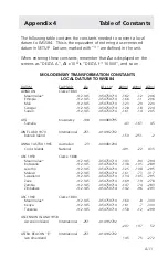
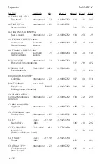
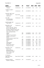
∆
X,
∆
Y,
∆
Z are the differences in height from the center of the earth from the
WGS model of the earth’s surface to the local datum’s model of the earth’s
surface.
∆
a = the difference from the WGS semi-major axis to that of the local datum.
∆
f ( x 10,000) = the difference in flattening from the WGS84 model to the local
datum.
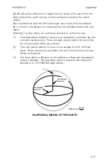
Flattening = (a-b)/a, where a = semi-major axis and b = semi-minor axis.
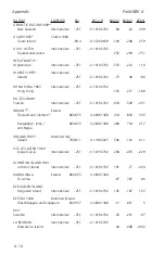
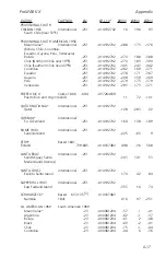
[1]
The Indian datum defined in the unit is an average for the Indian subconti-
nent and southeast Asia. These constants are provided in the event that
the more accurate offsets are required.
[2]
The Luzon datum defined in the unit is an average for all of the Philip-
pines. These constants are provided in the event that the more accurate
offsets are required.
[3]
This value reflects a difference in the definition of legal and international
meters in Namibia. (The semimajor axis for the Bessel 1841 Ellipsoid in
Namibia is: a = 6377483.865 legal meters.)
Semiminor
Axis (b)
Semimajor
Axis (a)
a - b
Flattening =
(a - b)
a
ELLIPSOIDAL MODEL OF THE EARTH
Содержание GPS PROMARK X
Страница 4: ......
Страница 10: ...vi...
Страница 14: ...Introduction ProMARK X 1 4...
Страница 92: ...Attributes ProMARK X 6 8...
Страница 188: ......

