50
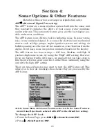
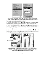
At left, Sonar Page Menu with Upper and Lower Limits command se-
lected. At right, Sonar Chart Limits menu, with Upper Limit selected.
To change the upper and lower limits:
1. From the Sonar Page, press
MENU
|
↓
to
U
PPER
A
ND
L
OWER
L
IMITS
|
ENT
.
The Sonar Chart Limits menu appears, with Upper Limit selected.
2. To set the upper limit, press
ENT
. Press
↑
or
↓
until the first digit is
correct, then
→
to move to the second digit. Repeat until the depth is
correct, then press
EXIT
.
3. To set the lower limit, press
↓
to
L
OWER
L
IMIT
|
ENT
. Press
↑
or
↓
until
the first digit is correct, then
→
to move to the second digit. Repeat un-
til the depth is correct, then press
EXIT
|
EXIT
|
EXIT
.
Normal display, in auto depth range mode, left. At right, display
"zoomed" with Upper and Lower Limits focusing on the portion
of the water column from 10 feet to 20 feet deep.
Area "zoomed"
Содержание M52 S/GPS
Страница 48: ...42 Notes ...
Страница 72: ...66 Notes ...
Страница 76: ...70 Notes ...
Страница 134: ...128 Notes ...
Страница 137: ...131 Notes ...
Страница 138: ...132 Notes ...

