


2-13
KMD 250 Pilot's Guide
Section 2
FIS Operation
Rev 4 Aug/2007
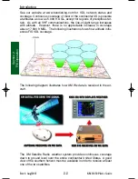
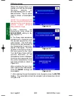
VALUE ADDED SERVICE WEATHER PRODUCTS
The following is a discussion of weather products offered with the value
added VDL subscription service. Accessing and navigating these ser-
vices will be discussed in detail later in this section.
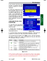
All basic and value-added products (except those identified as VDL only)
can also be obtained through a single fee-based XM subscription ser-
vice.
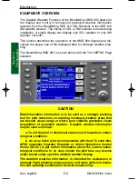
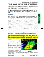
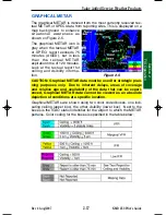
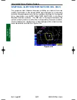
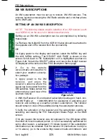
NEXRAD
Next Generation Radar (NEXRAD) is formally designated WSR-88D,
which stands for Weather Service Radar (Doppler) and was commis-
sioned in 1988.
FIS VDL provides NEXRAD base reflectivity and XM WX provides
NEXRAD composite reflectivity. Each NEXRAD ground radar site scan
is composed of separate beam scans at several elevation angles for
360 degrees around the site. Base reflectivity is the highest precipita-
tion echo (reflectivity) contained in the lowest NEXRAD radar elevation
angle scan (5 degrees). Composite reflectivity provides the highest
precipitation echoes within all of the elevation scan angles. The
NEXRAD base or composite reflectivity modes provide a display of
echo intensity depicted by colors. NEXRAD information is good for
identifying precipitation intensity.
This NEXRAD base reflectivity data product content consists of reflec-
tivity measured at the minimum scan angle of 0.5 degree elevation.
CAUTION: NEXRAD data must be used for strategic planning pur-
poses only. Due to inherent delays and relative age of the data
that can be experienced, NEXRAD data cannot be used for tactical
avoidance of weather.
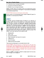
NEXRAD reflectivity images
older than 75 minutes are dis-
carded and no longer dis-
played.
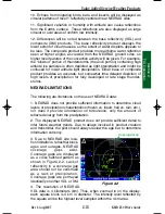
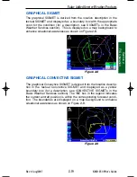
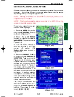
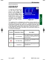
Figure 2-1 shows a typical
NEXRAD display. Political
boundaries, rivers, lakes, and
oceans are depicted in con-
junction with weather.
The display range may be
changed to zoom in on a spe-
cific area to get a more detailed weather picture, or zoom out to display
a wider range.
Figure 2-1
Value Added Service Weather Products
KMD 250 FIS_R4 8/13/07 10:07 AM Page 2-13
Содержание KMD 250
Страница 1: ...B KMD 250 Multi Function Display GPS Pilot s Guide N ...
Страница 9: ...R 6 Intentionally left blank ...
Страница 19: ...Table of Contents x KMD 250 Pilot s Guide Rev 4 Aug 2007 Intentionally left blank ...
Страница 59: ...1 40 KMD 250 Pilot s Guide Section 1 Basic Operation Rev 2 Apr 2004 Intentionally left blank Map Operation ...
Страница 73: ...1 54 Rev 2 Apr 2004 KMD 250 Pilot s Guide Section 1 Basic Operation User Waypoints Intentionally left blank ...
Страница 111: ...1 92 Rev 2 Apr 2004 KMD 250 Pilot s Guide Section 1 Basic Operation Map Display Icons ...
Страница 112: ...1 93 Rev 2 Apr 2004 KMD 250 Pilot s Guide Section 1 Basic Operation Map Display Icons ...
Страница 113: ...1 94 Rev 2 Apr 2004 KMD 250 Pilot s Guide Section 1 Basic Operation Map Display Icons ...
Страница 125: ...2 6 KMD 250 Pilot s Guide Section 2 FIS Operation Rev 4 Aug 2007 Intentionally left blank Introduction ...
Страница 147: ...2 28 Section 2 FIS Operation Rev 4 Aug 2007 KMD 250 Pilot s Guide FIS Subscriptions Intentionally left blank ...
Страница 181: ...2 62 Section 2 FIS Operation KMD 250 Pilot s Guide Normal Operation Rev 4 Aug 2007 Intentionally left blank ...
Страница 223: ...4 6 Rev 2 Apr 2004 KMD 250 Pilot s Guide Section 4 Stormscope Stormscope Operation Intentionally left blank ...
Страница 259: ...D 2 Rev 2 Apr 2004 KMD 250 Pilot s Guide Appendix D Navigation Terms Navigation Terms Intentionally left blank ...
Страница 273: ...I 14 Rev 4 Aug 2007 KMD 250 Pilot s Guide Index Index Intentionally left blank ...


