Geophysical Survey Systems, Inc.
UtilityScan with GS Software
Manual
MN71-307 Rev B
6
5
Next,
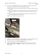
navigate to the
GPS Offset
option. This is the distance that your GPS is offset from the
threading on the top portion of the antenna near the handle attachments.
a)
If yours GPS is mounted on a pole using the threading on the antenna, your GPS Offset value
will be zero.
b)
If your GPS centered closer to the front of the antenna, your offset (cm/in) will be positive. If
your GPS is centered closer toward the handles of the antenna, your offset (cm/in) will be
negative.
c)
If you are using the Panasonic G2 internal GPS, measure the horizontal distance from the
threads on the antenna to the center of the tablet.
d)
If you are not using GPS, this value can be zero.
6
If you plan to collect data with GPS and would like a KMZ file to be exported, toggle the Export to
KMZ option on. For more information on exporting KMZ files see Appendix H.
7
Navigate to the System menu to
Units
and
Language
options.
8
Tap the selected parameter to change.
For example, if you wish to change the Units from
Imperial to Metric, tap the word
Imperial
. These settings will remain from session to session
unless changed.
Zero Offset
Содержание UtilityScan 50350HS
Страница 1: ...MN27 151 Rev A MN71 307 Rev B ...
Страница 4: ...Geophysical Survey Systems Inc UtilityScan with GS Software Manual ...
Страница 6: ...Geophysical Survey Systems Inc UtilityScan with GS Software Manual ...
Страница 8: ...Geophysical Survey Systems Inc UtilityScan with GS Software Manual MN71 307 Rev B 2 ...
Страница 14: ...Geophysical Survey Systems Inc UtilityScan with GS Software Manual MN71 307 Rev B 8 ...
Страница 20: ...Geophysical Survey Systems Inc UtilityScan with GS Software Manual MN71 307 Rev B 14 1 2 3 4 ...
Страница 46: ...Geophysical Survey Systems Inc UtilityScan with GS Software Manual MN71 307 Rev B 40 ...
Страница 47: ...Geophysical Survey Systems Inc UtilityScan with GS Software Manual MN71 307 Rev B 41 ...


