background image

45

Section 4

Cell Phone

Reference

Programming Security to Lock the Phone and
Selected Features

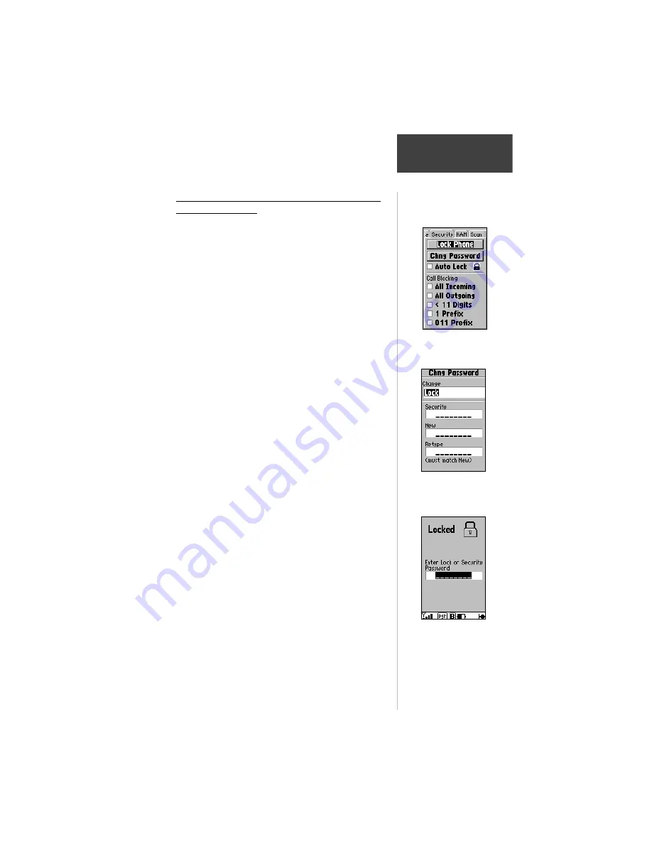
Lock Phone— 

To prevent unauthorized use of your

phone, you can lock it so that before you use it again you
must enter a lock password.

Auto Lock— 

To prevent unauthorized use of your

phone, you can set it to lock each time it is powered up
and the lock password or security password must be
entered before the phone can be used.  This setting, when
checked, also allows ‘Quick Lock’ of the phone by using
the ‘Lock Phone’ button on this page or by holding the
Menu key from any page.  When using ‘Quick Lock’ no
password is required to lock the phone.

Call Blocking— 

When you enable this feature you

can choose to exclude calls from these sources:  All
Incoming, All Outgoing, Less than 11 Digits, 1 Prefix and
011 Prefix.

About Passwords:

The NavTalk Pilot employs two types of passwords

(actually number codes are created using the phone keypad
to spell words) to secure use of the unit and its stored data.
It can be programmed so that a 

Lock Password

 can be

used to Lock or Unlock the Phone.

Stored Setup data and the Lock Password are

protected by a 

Security Password

.  It secures settings

such as Calling Card PIN, Auto Lock, Call Blocking, NAM
Selection, Emergency Number, Remote Command and
Scanning features.  The Security Password can also be
used to Lock or Unlock the phone.

NavTalk Pilot features that can be security protected

are accompanied by a padlock icon.  The icon is closed by
default on each power cycle and can be opened by
highlighting and entering the Security Password.

Each password is provided with a default:


Lock Password = 1234


Security Password = 1234567

‘Locked Phone’ Displays
after power ON.  Enter
Lock or Security
Password to Unlock.

Password Programming

Page for Lock Password

Setup Menu Security

Directory

Содержание NavTalk Pilot

Страница 1: ...Pilot s Guide Reference NavTalk PILOT NavTalk PILOT TM ...

Страница 2: ...rage medium to be viewed for personal use provided that such electronic or printed copy of this manual contains the complete text of this copyright notice and provided further that any unauthorized commercial distribution of this manual is strictly prohibited Information in this manual is subject to change without notice GARMIN Corporation reserves the right to change or improve its products and t...

Страница 3: ...tor sections get you started on using the NavTalk Pilot for basic Phone and GPS uses The Cellular Phone Reference and GPS Receiver Reference sections provide details about the advanced features of the NavTalk Pilot according to topic The Appendix contains information on items such as charging the battery accessories specifications glossary of terms and index Before getting started check to see tha...

Страница 4: ...ailable body of research to develop the ANSI Standard C95 1 The design of your NavTalk Pilot phone complies with FCC guidelines and those standards FCC Compliance Statement The NavTalk Pilot GPS Receiver Cellular Phone meets compliance require ments for maximum Specific Absorption Rate of radio wave emissions for the limit given in the FCC 96 326 Guideline Tested by APREL Laboratories an agent of ...

Страница 5: ... you have any reason to suspect that interference is taking place turn your phone OFF immediately Other Medical Devices If you use any other personal medical device consult the manufacturer of your device to determine if they are adequately shielded from external RF energy Your physician may be able to assist you in obtaining this information Turn you phone OFF in health care facilities when any r...

Страница 6: ...the aircraft adapter supplied with the NavTalk Pilot system In this configuration transmit power is reduced and routed to an external horizontally polarized antenna minimizing the potential for interference Driving Check the laws and regulations on the use of wireless telephones in the areas where you drive Always obey them Also if using your phone while driving please Give full attention to drivi...

Страница 7: ...sing possible injury Refer to airbag safety precautions contained in the vehicle owner s manual Do not mount the NavTalk Pilot in a place where the driver or passen gers are likely to impact it in an accident or collision The optional mounting hardware provided by GARMIN is not warranted against collision damage or the consequences thereof Warning When used in vehicles it is the sole responsibilit...

Страница 8: ...us at a reasonable cost We use a combination of governmental and private data sources that we identify as required in product literature and copyright messages displayed to the consumer Virtually all data sources contain inaccurate or incomplete data to some degree This is particularly true outside the United States where complete and accurate digital data is either not available or prohibitively ...

Страница 9: ...ilot from AirCell Adapter 13 Turning the NavTalk Pilot On Off 15 Switching from Cellular to GPS Modes 15 Adjusting Screen Contrast 15 Adjusting Volume 16 Adjusting Backlighting 16 Understanding the Status Bar 17 Main Menu Page 20 Cell Phone Pages 21 GPS Pages 23 Section 3 Basic Phone Operation 27 Placing a Call 29 Answering a Call 29 Unsuccessful Call Attempts 29 Dialing Errors 30 Auto Redial 30 E...

Страница 10: ...ting Up NavTalk Pilot Phone Features 42 Programming Phone Setup 43 Programming Security to Lock the Phone and Selected Features 45 Selecting an Active NAM 47 Scanning for Cellular Service 48 Setting Sound Functions for the NavTalk Pilot Cell Phone Features 49 Setting Date and Time 49 Setting Backlighting Interval Contrast Power Saver Remote Command 50 Setting Call Timers 51 Missed Calls List Featu...

Страница 11: ... Present Position 67 To View the HSI Page 68 To View the Highway Page 70 Section 6 GPS Receiver Reference 71 Entering Data and Accessing Programming 72 Satellite Status Page 72 Sky View and Signal Strength Bars 73 Receiver Status 73 Need to Select Initialization Prompt 74 EPE and DOP 74 Satellite Status Page Options Menu 75 Position Page 76 Map Page 77 Zooming Panning and Pointing 78 HSI Page 84 V...

Страница 12: ... Waypoints 103 GOTO Navigation 106 TracBack Navigation 108 Routes 111 Route Editing 113 Active Route Page 115 Main Menu 117 Section 7 Appendices 137 Appendix A Accessories 138 Appendix B Specifications 140 Appendix C Cellular Phone Dial String Codes 141 Appendix D Messages 142 Appendix E Maintenance 146 Appendix F Cellular Terminology 148 Appendix G Navigation Terminology 151 Appendix H Map Datums...

Страница 13: ... End a Call 30 Use Speed Dial 32 41 Use the PhoneBook 38 40 Redial Previously Called Numbers 41 Enter Speed Dial Names Numbers 42 Set Up Phone Features 42 Program Answer Mode Auto Redial Auto Data Calling Card 43 Program Security Lock 45 Program Lock and Security Passwords 46 Select an Active NAM 47 Set Date and Time 49 129 Set Backlighting Interval Contrast Power Saver Remote Command 50 Set Call ...

Страница 14: ...a Field 80 Measure Bearing and Distance 81 Change a Map Setup Feature 82 Manually Set a Course to Destination 85 Create a Vertical Navigation Profile 87 Display Highway Page Options 90 Use Waypoint Information 92 GOTO a Nearest Waypoint 98 Display the Nearest Location Options 99 Marking Present Position 100 Edit User Waypoints 103 To Change a User Waypoint Symbol 104 Create and Activate a TracBack...

Страница 15: ...eable battery pack must be fully charged So you may want to jump ahead to Battery Installation on page11 to begin that process then read this manual while waiting for the battery to complete its charging cycle This section introduces you to the NavTalk Pilot List of Features and a basic overview of GPS Navigation and Cellular Phone usage Because both NavTalk Pilot GPS and Cellular Phone functions ...

Страница 16: ...List and Time Date Stamp Auto Redial Auto Answer with Missed Call Indicator and Missed Calls List with Time Date Stamp Signal Strength and Battery Power Level Indicators DTMF Numeric Paging Intelligent Security Lock Audio Beep and Ring Volume Adjustment Lifetime and Resettable Call Timers Preferred SID List Call Restriction Minute Call Timer Reminder Beep Mute Control Emergency Auto Dialing LCD Di...

Страница 17: ...ed Nearest Waypoints Airports Runway Comm VOR NDB Int User WPT User List Cities GeoPoints Twenty Reversible Routes with up to 30 Waypoints Each plus TracBack Modes Cities Listings with Database Information Interstate Exits with Services Information 106 Map Datums Coordinates Include Lat Lon UTM UPS and Maidenhead GPS Phone Mode Select Map Page Zoom IN OUT ON OFF MARK Key LCD Display Arrow Keypad G...

Страница 18: ...l area and maintain a quality conversation as the call is handed off from cell site to cell site The signal is affected by atmospheric and geographic conditions that exist at the time you place or receive a call The NavTalk Pilot is preprogrammed with a Number Assignment Module NAM for AirCell service You can only use AirCell service when the unit is connected to the AirCell adapter installed in y...

Страница 19: ...rovider Instruction Card packaged with your NavTalk Pilot This will tell the service provider how to access special programming information needed to assign a phone number to the NavTalk Pilot 5 The service provider will ask you questions about the type of service options you desire and then program your NavTalk Pilot accordingly GPS Navigation Overview The Global Positioning System GPS is a syste...

Страница 20: ...ceiver needs to have an unobstructed clear view of the sky for best performance In a nutshell the GPS receiver s view of the sky will generally determine how fast you get a position fix or if you get a fix at all GPS signals are relatively weak and do not travel through rocks buildings people metal or heavy tree cover so remember to keep a clear view of the sky at all times for best performance On...

Страница 21: ...ighting 16 Understanding the Status Bar 17 Main Menu Page 20 Cell Phone Pages 21 GPS Pages 23 Getting Started Tour The getting started tour is divided into two sections Cell Phone and GPS To begin using your NavTalk Pilot for navigation purposes review the first part of the getting started tour and then complete the simulation exercise starting on page 61 To begin using the cellular phone review t...

Страница 22: ...turns the display from a sub menu page to a main page The ENTER Key The ENTER Key confirms data entry and on screen responses This key also activates highlighted fields to allow data entry The SEND Key The SEND Key dials phone numbers and answers phone calls It also performs the Flash Hook function pre empts Auto Pager mode and sends position when held for more than one second during a call The QU...

Страница 23: ...e The ALPHANUMERIC Keys Phone Keypad The phone keypad enters numbers for manual dialing and is used for Speed Dialing when keys are held for more than one second They are also used for data entry The 9 key is also used for Emergency dialing when held for more than one second The MARK Key The Mark Key marks waypoints in the GPS mode and enters a in the cellular mode The GOTO NRST Key The GOTO Key d...

Страница 24: ...e Highway page In the cellular mode they adjust volume up or down for the phone ringer beeper and speaker These keys pop to top the volume adjustment window whenever pressed with the exception of the map and highway pages The ARROW Keypad The ARROW keypad controls the movement of the cursor It is used to select options and positions It is used to enter both alpha characters and numeric data ...

Страница 25: ...k Pilot the plug is indexed to fit only in one direction Insert the transformer portion of the charger into a 120VAC wall outlet 3 Allow 14 to 16 hours for the initial charging of the Battery Pack NiMH batteries require conditioning during the first charging to establish maximum charge capacity 4 To determine if the battery pack has been fully charged turn on the NavTalk Pilot and observe the batt...

Страница 26: ...e aircraft is turned on refer to page 14 for details Do not use a battery pack if it gets wet as water can short across battery contacts For the same reason keep the battery pack away from loose metal objects such as keys paper clips etc Check contacts for dirt or corrosion if the battery pack does not charge properly If the battery pack has been stored at temperatures above or below the specified...

Страница 27: ...ngs on each side of the plug to fit it into the base of the unit Press the springs again to remove the plug 3 Turn on power to the aircraft and then turn on the NavTalk Pilot as explained on page 15 to check for proper connection When the unit is operating from aircraft power the Power Status icon will appear as an airplane symbol For additional information about Power Status icons see page 19 The...

Страница 28: ... at the bottom of the cradle for secure storage Charging the battery using the aircraft adapter The aircraft adapter provides power to operate the NavTalk Pilot whenever it is connected to the aircraft adapter cord and aircraft power is turned on Power is switched from battery to the adapter and the battery is fast charged unless completely depleted then a trickle charge will begin to protect the ...

Страница 29: ... mode when it was turned off Refer to page 61 for more information on initialization To Switch from the Cellular to GPS Modes 1 Press the GPS PHONE Mode key Toggle the key to switch back and forth from GPS to Cellular At this point you may want to adjust the screen contrast which you can do by selecting the GPS mode Satellite Status Page or Cellular Mode Status Page To Adjust the Screen Contrast 1...

Страница 30: ...e 3 To highlight a different field use the up down arrow keys Use left and right arrow keys to move the indicator Press QUIT to end or press no keys and allow to time out The volume levels are different when the unit is in the airplane and car cradles Volume is adjusted in the appropriate cradle in exactly the same way but can only be done when in said cradle When placed in the cradle the volume s...

Страница 31: ...n pieces of information Status Bar at the base of the Cellular Status Page The Cellular Signal Strength is indicated by an antenna with 1 to 5 signal bars The number of bars shows the strength of the signal received by your NavTalk Pilot No bars means you may not be able to call The display will change as you move with your unit If the signal is not strong enough to place a call try moving to a di...

Страница 32: ...or information on billing and dialing services When operating in the air cellular mode roaming does not apply as the air cellular system is universal in coverage You will switch from cell to cell as you travel but it will not be acknowledged by the NavTalk Pilot When the phone is not communicating with the cellular system either because the system is down or the phone is out of range the words No ...

Страница 33: ...rts you in the following ways Empty icon No charge left Low Battery message will appear followed by a periodic short tone If you ignore these warnings the NavTalk Pilot will automatically turn itself off when the battery has a very small charge left Simply charge the battery to resume normal operation A two prong plug icon indicates that you are using AC or DC power adapters An automobile icon wil...

Страница 34: ...hone Reference and Section 6 GPS Receiver Reference To select Setup from the Main Menu 1 Highlight Setup using the arrow keypad and press ENTER The Setup option provides a list of settings for both the GPS receiver and the cell phone presented as a series of file tabs For a brief look at how the Setup option works change the units of measure for distance and speed 1 Highlight the Units tab using t...

Страница 35: ...by pressing ENTER A message center which gives you easy access to a list of missed calls Detailed information on the message center is given in the reference section Configurable Data Fields These two data fields can be changed by selecting Change Fields from the cellular page menu The fields can be changed from Time of Day and System I D to two of 37 options see pages 37 and 38 System Identificat...

Страница 36: ...venient way of viewing and redialing the last nine phone numbers dialed To redial highlight the number and press SEND see page 32 Detailed information such as time of day and date is provided A scroll bar will appear as the list grows too big for the page Speed Dial Page The Speed Dial Page gives you a handy way of dialing numbers that you have listed on the page The page holds nine entries and an...

Страница 37: ... the status of your current position fix acquiring 2D 3D etc and your estimated position error EPE The Satellite Page and all other GPS main pages display the Status Bar at the base of each page Position Page The Position Page shows you where you are what direction you re heading and how fast you re going A graphic compass at the top of the page shows your direction of travel while you re moving y...

Страница 38: ...NavTalk Pilot features two different navigation pages HSI horizontal situation indicator and Highway page The HSI Page is first The HSI Page provides graphic steering guidance to a destination waypoint with an emphasis on the bearing to your destination and current direction of travel The Highway page also provides graphic steering guidance by displaying a three dimensional perspective of your cou...

Страница 39: ...page when your main concern is following a defined course Your present position is at the bottom center of the highway display The line down the middle of the highway represents your desired course As you navigate toward a waypoint the highway will actually move indicating the direction you re off course To stay on course simply move toward the center of the highway The fields at the top left of t...

Страница 40: ...urrent destination is marked with an arrow on the left hand side of the screen If no destination has been specified using the GOTO key or a route no waypoints will be listed on the page Messages The NavTalk Pilot uses on screen messages to alert you to important information Whenever a message appears press ENTER to acknowledge the message and return to the previous page you were viewing Refer to A...

Страница 41: ...icator 30 Using the PhoneBook 31 Speed Dialing 32 Last Dialed 32 Call Timers 33 Operating Modes 34 Basic Phone Operation The first time you use your NavTalk Pilot Cellular Phone you don t need to be completely familiar with every system feature to place and answer calls Once your Cellular Service Provider has programmed the phone portion of the NavTalk Pilot for cellular use you can begin using it...

Страница 42: ... monitored There are laws that protect you against eavesdropping the Electronic Communications Privacy Act of 1986 makes it a criminal offense to monitor cellular phone calls but you ll still want to be careful of what you say on your NavTalk Pilot Antenna Power ON OFF Volume Adjust GPS Phone Mode Select LCD Display Screen Arrow Keypad Send Key End Key Phone Keypad Emergency dial Key 9 ...

Страница 43: ...ing a Call To answer a call 1 Press SEND An incoming call is indicated by a ringing tone and the Call Press SEND message flashing on the display Once answered the call timer starts counting If a call is not answered the Call Press SEND message will continue flashing and the ringing tone will continue until SEND is pressed Pressing END will mute the ringer for this call When placing a call wait for...

Страница 44: ...igh low signal or the fast busy tone when attempting to place a call and wish to retry the call you can program the phone to redial the number The phone recognizes that the call was not completed then it redials every 15 seconds You can program this feature to redial up to nine times If you do not want automatic redialing press END at any time Auto Redial is programmed in the Phone setup page acce...

Страница 45: ...0 numbers To View the PhoneBook Page 1 Access the PhoneBook Page by pressing the PAGE key until the PhoneBook page is accessed 2 Use the left or right arrow keys to move from tab to tab through the PhoneBook and the up down keys to highlight the name you want to call 3 Press the SEND key and your call will be placed 4 The phone number dialed will be placed in the Last Dialed directory even if the ...

Страница 46: ...New Number programming page For information on entering new numbers refer to page 42 in the Cellular Phone Reference section Last Dialed The Last Dialed feature automatically stores up to nine phone numbers you have previously dialed for quick access for redialing 1 To access the Last Dialed page use the PAGE key to scroll through the pages until you reach the Last Dialed Page 2 Use the ARROW keyp...

Страница 47: ... the NavTalk Pilot to signal each time a minute of your current call has elapsed It beeps at 50 seconds into the first minute and at one minute intervals thereafter to help you save on minute increment call billing Last Call and Elapsed Time are always active and can be reset through the Call Timers function of the Main Menu 1 Access the Main Menu by pressing theMENU key twice 2 Scroll down to Tim...

Страница 48: ...is disabled to prevent interference to both the airborne cellular and conventional cellular networks The table below indicates the unit operating mode as it applies to ground speed and cradle docking Mode Docking GPS Velocity Cellular Operation Ground Undocked 100 mph Conventional Undocked 100 mph Off Undocked Undefined Conventional Airborne Docked 20 mph Off Docked 20 mph AirCell Docked Undefined...

Страница 49: ...ramming Security to Lock the Phone and Selected Features 45 Selecting an Active NAM 47 Scanning for Cellular Service 48 Setting Sound Functions for the NavTalk Pilot Cell Phone Features 49 Setting Date and Time 49 Setting Backlighting Interval Contrast Power Saver Remote Command 50 Setting Call Timers 51 Missed Calls List Features 52 Setting Up Dial String Codes for Automated Phone Services 53 Usi...

Страница 50: ...wer ON OFF Volume Adjust GPS Phone Mode Switch LCD Display Screen Menu Key Access to Feature Options Arrow Keypad Cursor and Data Entry Enter Key Selects Fields and Options Send Key End Key Phone Keypad Dialing and Data Entry Emergency Dial Key 9 ...

Страница 51: ...atus Page will be the page most often displayed during cell phone use The fields displayed are Your Active Phone Number Ground Phone Number Air Phone Number the Duration of Your Last Call the Last Dialed number or the Date The Message Center Two Configurable Data Fields default to Cellular System Identification Number and Time of Day The Status Bar Symbols which are explained in detail beginning o...

Страница 52: ...he two data fields 1 Press MENU to access the page menu and select Change Fields Then choose two from the thirty seven data options available To add or find a number in the PhoneBook and select the type of call answering 1 Press MENU to access the Cellular Status page menu 2 Scroll to the feature you want to program and press ENTER If you selected New PhoneBk or Spell n Find a new page will appear...

Страница 53: ... You can quickly select a tab by pressing the right left ARROW keys and then scrolling down to a listed name and number To view all data for a name press ENTER and the Edit Number display will appear A category identified as Other can be used to hold notes and temporary phone numbers recorded during phone conversations The Other category will store entries that begin with a numeral or other non al...

Страница 54: ...hted after pressing ENTER Move to the Speed Dial field press ENTER and assign a Speed Dial number if desired Then cursor to Done and press ENTER to complete the entry To remove a name from the PhoneBook 1 Highlight Delete Number and press ENTER You will be prompted to confirm the deletion before pressing ENTER to remove 2 To clear the PhoneBook of all names highlight Delete All and press ENTER You...

Страница 55: ...oor signal etc You can auto redial the number up to nine times This feature is programmed from the Phone Page of the Setup Program It will not redial a busy number or an unanswered call refer to Page 43 44 Using the Speed Dial Feature The Speed Dial Feature allows you to view name or Phone Keypad number assignments and hold the number key corresponding to the Speed Dial List number for more than o...

Страница 56: ...etup Press ENTER to access the Setup pages These pages are selected by tabs at the top of the screen Use the right left arrow keys to scroll from tab to tab There are several conventions for moving from field to field and making entries in each setup directory To setup phone features 1 Use the ARROW keypad to move up down and from side to side to cursor to and highlight a selected field 2 Press EN...

Страница 57: ... without ringing the phone or requiring the SEND key to be pressed and without displaying messages about location transfer If data is not detected within three seconds the call will ring for up to 50 seconds and is treated according to user selection Auto Answer Auto Pager or Manual Answer Auto Data selection can be locked and unlocked using the Security Password To program Answer Mode 1 Use the d...

Страница 58: ...ess the ENTER key To secure repeat Step 1 To enter your Calling Card Access PIN into the phone programming To automate calling card dialing you can store your PIN number in the unit for entry into a dialing string as a code C as explained on pages 53 through 54 Your PIN is password protected Refer to Security page 45 1 Repeat the steps above for programming Auto Data 2 Move to the PIN field and en...

Страница 59: ...About Passwords The NavTalk Pilot employs two types of passwords actually number codes are created using the phone keypad to spell words to secure use of the unit and its stored data It can be programmed so that a Lock Password can be used to Lock or Unlock the Phone Stored Setup data and the Lock Password are protected by a Security Password It secures settings such as Calling Card PIN Auto Lock ...

Страница 60: ...assword has been changed If not enter again 6 Repeat this process for the Lock password 7 Press QUIT to return to the security Setup page You can program the NavTalk Pilot to lock automati cally each time you turn it On Whenever you encounter a feature with a Padlock icon you must always enter the security password to access or change any programming To use Auto Lock 1 In the Security directory hi...

Страница 61: ...ive NAM the Phone Number for that NAM the Home System ID Side A or B and Electronic Serial Number ESN To select the phone number that is appropriate for the area you are in highlight the Active NAM field press ENTER and then select NAM 1 or 2 The NAM 3 is reserved for AirCell NAM which can only be used in the aircraft cradle Therefore this NAM is automatically selected and displayed on this page w...

Страница 62: ...nd should remain active in case a non home SID is in use Scanning selections for the AIR and NAM are set at the factory and cannot be changed while using this setup page The status bar will always show Home for AIR use even when using the non home SID To access scanning preferences 1 Highlight the padlock symbol and press ENTER 2 Enter your password using the phone keypad and press ENTER 3 Scroll ...

Страница 63: ...in progress The microphone can be muted during a call by holding the QUIT key The three volume settings can be set by pressing the ZOOM VOLUME keys at the top of the display screen anytime with exception of the map page where Zoom is functional If you are using the NavTalk Pilot unit with the GARMIN Vehicular Adapter Hands Free Kit you can adjust the External Mic Gain by highlighting that field an...

Страница 64: ... will turn back on when an incoming call rings in or any button on the unit is pressed Extensive use of backlighting will cause a significant reduction in battery life when powering the unit from the batteries only Enabling the Always On backlighting setting during charging will significantly lengthen charging time About Remote Command Remote Command is a feature that allows your NavTalk Pilot be ...

Страница 65: ...U and cursor to Query Location and press ENTER You will hear the DTMF tones and the Transferring Location message will appear 2 When the DTMF tone has been recognized the other unit will transmit the GPS location to your unit but only if it has the Remote Command feature enabled If it is not the tones will stop and the new position will not be acknowledged If the call is disconnected before the tr...

Страница 66: ... or remove an entry 1 Access the Phone page by pressing the PAGE key repeatedly 2 Scroll to the Missed Call icon and press ENTER The Missed Calls Page will display the list of calls in the order in which they were received The list will state No Answer and the time date for each call that was missed If you had enabled the Auto Pager feature and the caller entered their number then that number or N...

Страница 67: ...s DTMF tones To create a dial string for your DTMF application use the following codes to create appropriate pauses stops and links in the dial string The chart on the next page lists DTMF codes and their function EXAMPLES OF CODED DIAL STRINGS 1 Use a D code before a string of numbers and they will all be sent as DTMF tones Example D3124545 the phone number 2 Use the P code to create a 5 second p...

Страница 68: ...ther unit for position reporting StarandPoundKeys UsedforstandardDTMFtones P S D L T C Q 4 Use the C code to recall your Calling Card PIN from its stored and secured location on the Setup Menu Phone Directory sub menu Example Enter your access number to your carrier wait for tone enter 0 area code a 7 digit phone number wait for tone enter a C code for your calling card 18778000P09137226578PC 5 Us...

Страница 69: ... 2 Cursor down to Use Prefix Dial and press ENTER The Enter Prefix window will appear 3 Press ENTER then use the phone keypad to enter the dialing prefix When finished press ENTER to return to the PhoneBook Page 4 Select the name from the Phonebook or other page that lists numbers that you wish to dial and press SEND The prefix will be displayed on the Cellular Status display along with the number...

Страница 70: ...osition via DTMF tones or press MENU and select Send Location or use the T code in your dialing string and then press ENTER To receive a GPS Position Report 1 Connect to the reporting caller using the Phone portion of the NavTalk Pilot 2 Press MENU and select Query Location from the Dialing Page or use the Q code in your dialing string 3 When the new position is received a pop up message Do you wa...

Страница 71: ...ramming Page will appear 3 Cursor to the Emergency number field and press ENTER Use the phone keypad to enter the number You may enter 911 or an emergency number of your choice then press ENTER to record If the padlock icon is closed you must enter the Security Lock Code to open before accessing the number field 4 Cursor to the Feature Enabled box and press ENTER to enable Emergency Calling If you...

Страница 72: ... to insure that you have entered the correct number You can activate this feature even when the phone is locked and you can also manually enter 911 while the unit is locked The emergency number will not appear on the Last Dialed Number list to prevent inadvertent emergency calls Emergency calling will override scan options and use any available system Therefore the NavTalk Pilot may roam for an em...

Страница 73: ...Cycle Through the Main Pages 64 Selecting the Map Page 65 To Select the GOTO Destination 67 To Mark your Present Position 67 To View the HSI Page 68 To View the Highway Page 70 Using the Simulator Program To Learn Basic GPS Operation The first time you use your NavTalk Pilot GPS Receiver you won t need to be completely familiar with every feature to successfully navigate to and from locations of y...

Страница 74: ...ion 5 Basic GPS Using the Simulator Internal GPS Antenna Power ON OFF Key Map Page Zoom IN OUT Keys GPS Phone Mode Switch LCD Display Screen Quit Key Arrow Keypad Page Key Enter Key Menu Key Mark Key GOTO Key ...

Страница 75: ...r be used for actual navigation The receiver cannot be turned on with the simulator mode active If you forget to return it to normal operation before turning the unit off it will automatically return to normal operation the next time you use it However if you switch from simulated navigation to the cellular phone mode and then back to GPS mode the unit will remain in the simulated navigation mode ...

Страница 76: ...nitialize the GPS receiver 1 Press ENTER to acknowledge the message and see a list of initialization options or select Initialize Position from the Satellite Status Page Menu 2 Use the ARROW keypad to highlight Use Map and press ENTER 3 Use the ARROW keypad to point the map cursor to your approximate location within 250 miles You can also use the IN OUT zoom keys to make it easier to identify your...

Страница 77: ...e unit to search the sky automatically Selecting the Simulator Mode Using the Simulator Mode is the easiest method for learning the basics of GPS navigation and using the NavTalk Pilot GPS features You do not need to be operating the NavTalk Pilot in the GPS Mode The Main Menu is universal to both Phone and GPS modes To select the simulator mode 1 Press MENU twice to access the main menu 2 Use the...

Страница 78: ...igation based on the information acquired when you initialized the unit To Cycle Through the Main Pages 1 Press PAGE to move forward through each of the main pages in sequence 2 Press QUIT to move through the pages in reverse order In normal mode the unit would automatically sequence from the Satellite Status Page to the Map Page once enough satellites were received to determine your position At t...

Страница 79: ...the zoom IN key to select a smaller map scale and display a smaller geographic area 2 Press the zoom OUT key to select a larger map scale and display a larger geographic area Select a five mile scale by pressing the zoom IN or OUT key repeatedly MapSource and Jeppesen databases are selectable as ON OFF or Air On Gnd On The Air On Gnd On selection is the default When the unit is in the aircraft or ...

Страница 80: ...fier is highlighted 3 Press ENTER to view the database information for the selected waypoint If an airport is selected use the left right arrow keys to select between Airport Runway and Comm information pages 4 When finished reviewing the information press QUIT to return to the Map Page Pressing QUIT a second time will end the panning operation and return the map to your present position The curso...

Страница 81: ...the TracBack feature at the end of this exercise to retrace your path by observing all waypoints on the route in reverse order For now just mark your position as a waypoint To Mark your Present Position 1 Press the MARK key The MARK key marks your present position whether in or out of the pan mode The Mark Waypoint Page will appear with an automatically assigned three digit identifier located at t...

Страница 82: ... have returned to the Map Page Notice that the information displayed on the Map Page is slowly moving as it would in actual use The primary navigation displays are the HSI Page Position Page Map Page and Highway Page To View the HSI Page 1 Press the PAGE key repeatedly until the HSI Horizontal Situation Indicator Page is displayed The HSI Page provides graphic steering guidance to a destination wa...

Страница 83: ... CDI to full left or right limits As you approach the waypoint a TO FROM indicator will signal waypoint crossing The current speed distance to the next waypoint time to the next waypoint and vertical speed to target are all displayed above the graphic HSI To see how all this works on the simulated trip head off course and watch the displays change Use the left right arrow keys to move off course o...

Страница 84: ... heading directly to the waypoint If not turn in the direction of the pointer and the pointer will turn around pointing straight ahead when you begin moving toward the destination waypoint Try moving on and off course again by using the left right arrow keys and watch as the display and bearing pointer change Keep in mind that for many of the features such as Routes Track Logs and Waypoints List t...

Страница 85: ...ptions 79 HSI Page 84 Vertical Navigation 87 Highway Page 90 Waypoint Information Pages 92 Airport Information Page 95 Runway Information Page 95 Communication Information Page 96 VOR Information Page 96 NDB Information Page 96 Intersection Information Page 96 Nearest Pages 97 Marking Present Position 100 Marking User Waypoints on the Map Page 101 Creating User Waypoints by Text Entry 101 Waypoint...

Страница 86: ...ides a visual reference of various GPS receiver functions including current satellite coverage receiver operating mode battery level and position accuracy As the receiver locks onto satellites a signal strength bar will appear for each satellite in view with the appropriate satellite number 01 32 underneath each bar The progress of satellite acquisition is shown in three stages No signal strength ...

Страница 87: ... field will indicate a 2D or 3D status For 2D you may need to enter your altitude See pages 75 and 76 Receiver Status Receiver status is indicated at the top of the page The status will be shown as one of the following conditions Searching the unit is looking for any available satellites in view AutoLocate the unit is initializing and collecting new almanac data This process can take up to 5 minut...

Страница 88: ...er of satellites are received to determine a position fix a message will appear prompting you to initialize the receiver This allows you to specify a starting location from which to search for satellites or to enable the AutoLocate feature It is also useful if you have traveled over 500 miles with the receiver off This message will automatically appear when you first use your NavTalk Pilot The pro...

Страница 89: ...m the last location the unit was used To select AutoLocate highlight AutoLocate and press ENTER Initialize Position designates your approximate position in order to speed up satellite acquisition This option may be used instead of AutoLocate To initialize your starting position 1 Highlight Initialize Position and press ENTER 2 Designate your approximate position on the map using the ARROW keypad a...

Страница 90: ...e for your present position These times and the current time display at the bottom of the page can be displayed in local or UTC zulu time The lower left hand corner of the page shows your current latitude and longitude in degrees and minutes default The unit uses this basic information to mark exact positions as waypoints Average speed sunrise and sunset times also appear on the Position Page as d...

Страница 91: ...l Time Max Speed Odometer Speed Sunrise at present position Sunset at present position System ID Track Trip Odometer Trip Timer User Timer and Voltage See Section 7 for descriptions of Navigation terms Restore Defaults resets all data field readings to their factory default settings To restore the factory default settings highlight Restore Defaults and press ENTER Map Page The unit features a powe...

Страница 92: ...Map Page zooming panning and pointing The map has 23 map scales from 120 feet to 500 miles or 30 meters to 800 km which are selected by pressing the IN and OUT zoom keys The current map scale is indicated in the bottom left corner of the map display To change the map scale 1 Press ZOOM IN to see a smaller area with more detail 2 Press ZOOM OUT to see a larger area with less detail Another function...

Страница 93: ...t the location before the GOTO is initiated To cancel the pan function and re center the map on your position 1 Press the QUIT key Map Page Options Many features of the unit are menu driven Each of the main pages has an options menu allowing you to custom tailor the corresponding page to your preferences and or select special features which specifically relate to that page To display the Map Page ...

Страница 94: ...hows the number of maps downloaded from the optional MapSource software package and the amount of memory used in kilobytes MapSource allows you to supplement the built in map with additional detail including residential streets Each downloaded map is described by name and may be deselected if you wish to retain the map in memory but not display the data on the Map Page When a MapSource file is sel...

Страница 95: ...row is not used Once you move the arrow with the arrow keys this menu selection becomes active Map Setup allows you to configure the map display to your preferences including map orientation land data enable disable Jeppesen data enable disable automatic zoom airspace boundaries and text size The map setup option uses a file tab feature making it easier to organize the various settings Large airpo...

Страница 96: ...op of the map display to your desired course Press ENTER to accept the selected option Map Detail Orientation AutoZoom Accuracy Circle Source Basemap Aviation Data Mapsource Line Track Log Active Route Lines Local Roads Street Label Text Points All Waypoints Waypoint Text Active Route Wpts Common Exits Special Exits Apt Large Medium Small Airports and Text Nav VORs NDBs Intersections and Text Ctrl...

Страница 97: ...hat this data will be displayed only when the unit is in the ground mode i e Gnd On Ground mode only or not in the aircraft cradle These settings allow you to display map data according to your preference If declutter is important then the settings of Air On Gnd On will turn the Jeppesen Data and MapSource data On or Off automatically as the unit is used in or out of the aircraft cradle If you lik...

Страница 98: ...urse and whether or not you re on that course See page 68 Course deviation is indicated by a CDI scale across the center of the HSI and a moving D bar course deviation bar If you move off course the D bar will indicate how far off course you are based upon its placement along the course deviation scale To get back on course and center the D bar simply steer toward the D bar The CDI scale setting i...

Страница 99: ...other is for deviating around weather when flying a flight planned route When using the NavTalk Pilot s route features Set OBS and Hold will prevent the unit from automatically sequencing to the next route waypoint To maintain the OBS course and retain automatic sequencing you must also select the Release Hold option described later To manually set a course to the destination waypoint 1 Highlight ...

Страница 100: ...h a smaller compass type display and two user selectable large character data fields If Big Numbers is selected HSI will appear as an option instead To toggle between HSI and Big Numbers page formats highlight Big Numbers or HSI and press ENTER Change fields allows you to choose the data displayed on four user selectable data fields There are thirty four available data types including Average AVG ...

Страница 101: ...tical navigation profile 1 Select the Main Menu by pressing MENU twice 2 Select Vertical Nav using the ARROW keypad and press ENTER 3 With the Target Altitude field highlighted press ENTER Enter the desired target altitude and press ENTER 4 With the altitude reference field immediately to the right of Target Altitude highlighted press ENTER Select Above Wpt or MSL as desired and press ENTER Above ...

Страница 102: ...utilizes a 400 foot per minute descent rate To change the rate highlight the Profile field press ENTER enter a new rate and press ENTER again 9 To enable disable all vertical navigation messages highlight the Message field and press ENTER Select On or Off as desired and press ENTER With the profile set the HSI Page will guide you through the maneuver Data fields on the HSI Page can be configured t...

Страница 103: ...ovided The time to vertical navigation Time to VNV figure will go blank and the VNAV indicator will disappear from the HSI Page WARNING GPS accuracy may be degraded by the U S Department of Defense imposed Selective Availability SA program With SA on GPS altitude may be in error by several hundred feet Errors of this magnitude may result in fluctuations in the VNAV indicator on the HSI Page The Na...

Страница 104: ...rovides visual guidance to the destination waypoint and keeps you on your intended course line Your course is represented by the centerline down the middle of the graphic highway As you head toward your destination the highway perspective will move to indicate your progress to the waypoint and which direction you should steer to stay on course If you are navigating a route the highway display will...

Страница 105: ...ring Distance ETA to Destination DEST Speed Time to Destination DEST Track a Trip Odometer and a Bearing Pointer See section 7 for descriptions of navigation terms To change a data field 1 Highlight Change Fields and press ENTER 2 Highlight the data field you wish to change and press ENTER 3 Select the type of data you want to appear on this field and press ENTER Restore Defaults resets all data f...

Страница 106: ...ility Name Position Freq Int Intersection Name Region Country Nearest VOR User Wpt Name Position User Comments Reference Waypoint User List Name Symbol Total Number of User Waypoints Created Waypoint Information Pages Your NavTalk Pilot uses a built in Jeppesen database to provide position and facility information for thousands of airports VORs NDBs and intersections Each facility in the database ...

Страница 107: ...g the ARROW keypad and press ENTER 2 Use the ARROW or phone keypad to enter the desired identifier 3 As the identifier is entered the unit will scroll through the database displaying any waypoints with the same identifier letters you have entered to that point When the desired waypoint is displayed press ENTER Waypoints are selected by identifier or name Enter the desired identifier in the waypoin...

Страница 108: ...egory and region country makes it easy to identify the correct one To select the desired waypoint from a list of duplicates highlight the desired waypoint and press ENTER The Airport VOR and NDB information pages also allow you to retrieve the desired waypoint by entering the facility name or the city name To select the desired waypoint by facility or city name 1 Use the ARROW keypad to highlight ...

Страница 109: ...ounding area The surface type information can be any one of hard turf sealed gravel dirt soft unknown or water The lighting information will indicate one of five lighting schemes part time full time pilot controlled with frequency no lighting or un known If the selected airport has more than one runway additional runway data can be viewed by selecting another runway from the runway designation fie...

Страница 110: ...lity type terminal low altitude or high altitude is also indicated If DME or TACAN equipment is co located at the site it will be indicated next to the transmitting frequency Likewise if the facility broadcasts weather information WX will appear next to the transmitting frequency Position information will be in the format specified on the Setup pages see page 123 NDB Information Page The NDB Infor...

Страница 111: ...est Pages 1 Press and hold the GOTO key for two 2 seconds 2 Select the desired information by highlighting the appropriate tab from the chart Additional information is stored in the unit s Jeppesen database This information may be retrieved using the Waypoints option on the Main Menu but it is also available from the Nearest Page To view additional information for a nearest airport VOR NDB interse...

Страница 112: ... with Identifier Bearing and Distance VORs Nine Nearest with Identifier Bearing and Distance NDBs Nine Nearest with Identifier Bearing and Distance Ints Nine Nearest with Name Bearing and Distance User Nine Nearest with Name Bearing and Wpts Distance ARTCC Five Nearest with Bearing To Distance and Frequency FSS Five Nearest with Bearing To Distance Freq s and VOR for Duplex Opertion Airspace Up to...

Страница 113: ...es The following options are available Large Medium and Small Cities and Small Towns Exits with services without services rest areas service areas toll booths welcome centers weigh stations and other exit categories Geographical Points lists airports and depending on MapSource data includes attractions emer gency facilities food and drink lodging natural points services and other To display the ne...

Страница 114: ...aging reduces the effects of selective availability and improves the accuracy of the position reading See page 76 77 for more information Marking Present Position The unit s MARK feature lets you quickly capture your present position in order to create a new user waypoint You must be locked onto satellites with a valid position fix to mark your present position To mark your present position 1 Pres...

Страница 115: ...me field and press ENTER Use the ARROW or phone keypad to enter the new waypoint name and symbol if desired and press ENTER when finished 5 To save the waypoint in memory highlight Done and press ENTER Creating User Waypoints by Text Entry User waypoints may be created by manually entering the position coordinates or by entering the bearing and distance from an existing waypoint or present positio...

Страница 116: ...ference position Use the same procedure to enter the bearing BRG and distance DST from the reference waypoint to the new waypoint Press ENTER after each data item is selected with the ARROW keypad 8 To save the new waypoint in memory highlight Done and press ENTER Waypoint List Options The Waypoint Options were displayed using the first three steps above In addition to New Waypoint there are addit...

Страница 117: ... or from the waypoint information pages User Wpt or User List tabs To access the Edit Waypoint Page for a user waypoint 1 Use the ARROW keypad to select the desired user waypoint on the map display and press ENTER Or 2 Highlight Waypoints from the Main Menu and press ENTER Select the desired file tab If User Wpt is selected press MENU select Edit Waypoint and press ENTER If User List is selected h...

Страница 118: ...nge the position coordinates or highlight the reference waypoint name bearing or distance fields to change the reference waypoint information Press ENTER to begin editing 2 Use the ARROW or phone keypad to enter the new information When finished press ENTER to accept A user waypoint s position may be edited graphically using the map display To move a waypoint s position on the map display 1 From t...

Страница 119: ...w the highlighted user waypoint will appear on the map display Options are provided to show symbol name symbol comment or symbol only To change the display options for a user waypoint 1 Highlight Display Options and press ENTER 2 Highlight the desired option and press ENTER Average Position allows you to average position samples over time to improve the accuracy of the position reading and save th...

Страница 120: ...y The GOTO key can be used by itself after highlighting a waypoint name on a list or after designating a position on the map display To GOTO a waypoint 1 Press GOTO The GOTO page shows a series of file tabs for Recent waypoints User waypoints or Spell n Find 2 To GOTO a recently used waypoint select the Recent tab highlight the desired waypoint and press ENTER 3 To GOTO a user waypoint select the ...

Страница 121: ...s ENTER to begin navigating To select a GOTO waypoint by facility name or city applicable to airports VORs and NDBs only 1 Press GOTO and select the Spell n Find tab as described previously 2 Highlight the facility name or city name field and press ENTER 3 Use the ARROW or phone keypad to enter the facility name or city name As you enter the first few characters the unit s Spell n Find feature wil...

Страница 122: ...ation feature allows you to retrace your path using the Track Log automatically stored in the receiver s memory This eliminates the need to manually store waypoints along the way A Track Log is an electronic breadcrumb trail showing the path you have traveled Your unit can be set to automatically record track log points anytime the receiver is on and locked onto satellites see page 119 TracBack ro...

Страница 123: ...d press ENTER 4 Press ENTER to create and activate the TracBack route Or 5 Press MENU again to see the options 6 Highlight TracBack and press ENTER to create and activate the TracBack route Using either method a message box will appear while the unit analyzes the data and creates the route Once a TracBack has been activated the unit will take the Track Log currently stored in memory and divide it ...

Страница 124: ...t will create the new waypoints using the first available three digit number If the Track Log Setup Page s interval field is set to Time the route may not follow your exact path Keep the interval field set to Resolution for best results If the receiver is turned off or satellite coverage is lost during your trip TracBack will draw a straight line between any point where coverage was lost and where...

Страница 125: ... route so make note of the route name for future reference 5 Highlight the first waypoint name field and press ENTER to begin entering the name of an existing waypoint in memory 6 Use the ARROW or phone keypad to enter the name of the route waypoint and press ENTER 7 Highlight the next waypoint name field and repeat step 6 until all route waypoints have been added to the route Route List The unit ...

Страница 126: ... desired route and press ENTER to display the Route Edit Page 3 Highlight the route name field top line and press ENTER to begin editing 4 Use the ARROW or phone keypad to enter the desired name and press ENTER when finished When a route is highlighted on the Route List additional functions are available from the Route Options To display the Route Options press MENU with the Route List displayed T...

Страница 127: ... of the route To delete a route from memory 1 Highlight Delete Route and press ENTER A confirmation page will appear 2 Press ENTER to delete the route or QUIT to cancel Delete All allows you to remove all routes from memory The waypoints contained in all stored routes will remain in memory but not as part of any route To delete all routes from memory 1 Highlight Delete All and press ENTER A confir...

Страница 128: ...ank line for the new waypoint Enter the name of the new waypoint and press ENTER 5 To delete a waypoint from the route highlight the waypoint you wish to delete and press MENU Highlight Remove Wpt on the pop up menu and press ENTER 6 To reverse the order of waypoints in the route highlight Invert and press ENTER 7 To begin navigating a route highlight Activate and press ENTER To edit a route from ...

Страница 129: ...n sequence using the PAGE or QUIT keys is the Active Route Page Whenever you have activated a route GOTO or TracBack the Active Route Page will show each waypoint by name of the active route along with the desired course distance to waypoint time to each waypoint fuel requirements or sunrise sunset times at each route waypoint As you navigate the route the information on the Active Route Page will...

Страница 130: ... and press ENTER The trip planning screen is displayed showing information for the entire route 2 To review information for a single route leg highlight the plan field press ENTER and select the desired route leg using the ARROW keypad Press ENTER to confirm 3 To enter a speed for your trip highlight the speed field press ENTER and use the ARROW keypad to select the desired speed Press ENTER to co...

Страница 131: ...waypoint in the route If no route waypoint is highlighted this option is not available See page 92 for waypoint review information Delete Route allows you to remove the current route from memory The waypoints contained in the route will still appear in memory but not as part of the route See page 113 Main Menu The Main Menu provides access to the waypoints cities routes track logs trip computer ve...

Страница 132: ...haracter of the name of the city you want to find Move the cursor to the right then scroll through the alphabet until you find the next letter of the city you want Repeat until the name of the city appears If the city you are looking for does not appear it is not listed in the map database 3 When using the Spell n Find feature many cities will appear that match the first few characters of the name...

Страница 133: ...ich the track plot is recorded Three interval settings are available Time Records track log based on a user defined time interval Resolution default Records track log based upon a user defined variance from your course over ground The resolution option is recom mended for the most efficient use of memory and TracBack performance The distance value entered in the Interval Value field is the maximum...

Страница 134: ... a target altitude at a specified location See page 87 E6B provides calculation features for density altitude true airspeed and winds aloft The winds aloft function will calculate wind direction speed and the head tail wind component To calculate density altitude and true airspeed 1 Select the Density Altitude file tab using the ARROW keypad 2 Highlight the Indicated Altitude field and press ENTER...

Страница 135: ... total lifetime call usage The unit can also be set to signal each time a minute of your current call has elapsed See pages 33 and 51 for Call Timers information System timers allow you to select either count up or count down for the User Timer For a count down timer you may specify the count down duration To select a user timer setting 1 For a count down timer highlight the User Timer field in th...

Страница 136: ...y assistance service The unit will allow emergency auto dialing even if the unit is Locked Press and hold the red 9 key for more than two seconds If you want to cancel before the call is connected press END To Program Emergency Calling 1 Press the MENU key twice to access the Menu page 2 Scroll down to Emergency and press ENTER The Emergency programming page will appear 3 Move the cursor to the Em...

Страница 137: ...vertent emergency calls Emergency calling will override scan options and use any available system Therefore the unit may roam for an emergency call even though HOME is the only scan selected Setup provides a group of pages to perform various system setup functions including selection of position format units of measure setting various alarms configuring the display and backlighting Each available ...

Страница 138: ...e and Date Format System Backlight Timeout Ignition Power Off Power Saver and Remote Command Simulator Mode Speed Track Track Control and Altitude Deviation Units Position Format Map Datum Units of Measure for Distance and Speed Heading Altitude Elevation Alarms Alarm Clock Arrival Alarm Off Course Alarm I O Interface Format NMEA RCTM GARMIN Aviation To display the desired information highlight th...

Страница 139: ...ypically Class D Restricted allows you to enable disable alarms for restricted areas MOAs lets you enable disable alarms for military operations areas Other SUAs provides alarms for other special use airspace categories including training caution danger warning and alert areas Mode C Veils provides an alarm within the outer 30 mile limit of an airspace as depicted on sectional and IFR enroute char...

Страница 140: ...ithin the next ten minutes Airspace Near and Ahead is displayed when you are within two nautical miles of an airspace and your current course will take you inside the airspace Inside Airspace occurs when you have entered the boundaries of the airspace Near Airspace Less Than 2 nm appears when you are within two nautical miles of an airspace but your current course will not take you inside the airs...

Страница 141: ...e runway length and press ENTER Phone There are three Answer Mode options Manual Answer Auto Answer Hands Free for headsets and Auto Pager Refer to Section 4 for the Phone tab menu selections Security To prevent unauthorized use of your phone you can set it to lock each time it is powered up and the lock password or security password must be entered before the phone can be used Refer to Section 4 ...

Страница 142: ... total silence the Beeps must also be set to Off The microphone setting cannot be changed unless there is a call in progress The microphone can be muted during a call by holding the QUIT key You can also press and hold the QUIT key while in a call to toggle between Open and Mute The three volume settings can be set by pressing the ZOOM VOLUME keys at the top of the display screen anytime except on...

Страница 143: ...nter the local time zone 1 Highlight the Local Time Zone field and press ENTER 2 Select the desired offset amount in hours and minutes using the ARROW keypad and press ENTER 3 Highlight the offset direction field immediately to the right and press ENTER 4 Select Behind UTC or Ahead of UTC as appropri ate and press ENTER Date and Time displays the current date and time based on the settings made ab...

Страница 144: ...imeout 1 Highlight the Ignition field and press ENTER 2 To keep the unit on continuously select Always On and press ENTER Or 3 To set a timeout duration select the desired time period and press ENTER Power Saver means that the GPS will operate on a reduced power cycle thereby lessening internal process ing activity During periods of high dynamics such as turning or acceleration the GPS reverts to ...

Страница 145: ...to the simulator tour in Section 5 To enable disable the built in simulator 1 Highlight the Mode field and press ENTER 2 Select Simulator Off or Simulator On as desired and press ENTER Speed lets you select a simulated speed when the simulator is enabled Track Control allows the built in simulator to automatically align track heading to the desired course when using a GOTO or route or it allows yo...

Страница 146: ...minutes and decimal seconds Maidenhead APRS use tracking systems UTM UPS Universal Transverse Mercator Universal Polar Stereographic grids User UTM Grid User defined Universal Transverse Mercator grid WARNING If User MV is selected you must periodically update the magnetic variation as your position changes Using this setting the NavTalk Pilot will not automatically calculate and update the magnet...

Страница 147: ...d or the message will not occur To enable disable the alarm clock 1 Highlight the Clock Alarm field and press ENTER 2 Select On or Off as desired and press ENTER 3 If enabling the alarm highlight the time field to the immediate right and press ENTER Enter the alarm time using the ARROW keypad and press ENTER Arrival Alarm provides an alarm message once you ve come within a set distance from your d...

Страница 148: ... route track log data with a PC or with another NavTalk Pilot NMEA supports the input output of standard NMEA 0183 version 2 0 data None provides no interfacing capabilities RTCM NMEA allows Differential GPS DGPS input using a standard RTCM format and also provides NMEA 0183 version 2 0 output RTCM In allows DGPS input using a standard RTCM format without any output capabilities RTCM Text allows D...

Страница 149: ...red setting and press ENTER The Transfer Mode field allows you to specify what information to request or send to a second unit The Host setting lets you control all data transfer functions from the second unit or from a PC 4 If an RTCM format is selected additional fields are provided to control a GARMIN GBR 21 Beacon Receiver directly from your unit You can enter the beacon frequency and bit rate...

Страница 150: ...136 Section 6 GPS Receiver Reference This page intentionally left blank ...

Страница 151: ... Accessories 138 B Specifications 140 C Cellular Phone Dial String Codes 141 D Messages 142 E Maintenance 146 F Cellular Terminology 148 G Navigation Terminology 151 H Map Datums 154 I Index 157 J Limited Warranty 160 Appendices Section 7 ...

Страница 152: ...omprehensive guide to unit operation and feature programming This manual Aircraft Provisions Kit Part No 010 00220 00 Navtalk Pilot aircraft adaper kit includes installation hardware cradle adapter box wiring harness and installation instructions Not shown Optional Accessories Not provided with the NavTalk Pilot Leather Carrying Case Part No 010 10220 00 Protects the NavTalk Pilot while allowing f...

Страница 153: ... kit above Not shown Remote Cellular Antenna Part No 010 10243 00 Magnetic mount cellular antenna for vehicle mounting Can be used only with the vehicle adapter kit above Not shown Replacement NavTalk Pilot Antenna Part No 700 00007 00 Replacement for a lost or damaged cellular antenna that is supplied with the NavTalk Pilot Not shown AirCell Antenna Kit Part No 010 10278 00 Includes AirCell anten...

Страница 154: ...Parallel Channel Acquisition time Approx 15 seconds warm start Approx 45 seconds EZinit cold start Approx 5 minutes AutoLocate Update Rate 1 second continuous Position Accuracy 1 5 meters 3 15 ft with DGPS corrections1 15 meters 49 ft RMS2 VelocityAccuracy 0 1 knot RMS steady state Dynamics Performs to specifications to 6 g s Interfaces NMEA 0183 RTCM 104 for DGPS corrections and RS 232 for PC int...

Страница 155: ...s other phone for position also queries another phone for position from the Dialing Page by selecting Query Location option This feature is active only during a call S Stop dialing until SEND key is pressed T Transmit GPS Position via DTMF tones also transmit position while in a call by holding SEND for two seconds also transmits position from the Dialing Page by selecting the Send Location option...

Страница 156: ...pace and you are projected to enter the airspace based on your current track speed and altitude Alarm Clock The alarm clock time that was set from the Alarms submenu has been reached Almanac data complete The almanac data for all satellites have been collected Approaching You are one minute away from reaching a destination waypoint Approaching Target Altitude The current altitude is within 1000 fe...

Страница 157: ...es of special use or controlled airspace Leg not Smoothed The upcoming route leg is too short for smooth waypoint transitions Location Transfer Complete Your GPS location DTMF signal has been received and recorded Location Transfer Failed Your GPS location DTMF signal tone was not received NavTalk Pilot sends 5 times before this message appears Maintenance Mode The cellular system is conducting ma...

Страница 158: ...ge The NavTalk Pilot cannot acquire the necessary number of satellites to compute a position Try another location with a clearer view of the sky Power Down and Re init The NavTalk Pilot cannot calculate a position due to abnormal satellite conditions Turn power off and use other means to verify the last position shown Try the unit again later possibly in a different location RAM Failed The NavTalk...

Страница 159: ...Steep Turn Ahead This message appears approximately one minute prior to a turn that requires a bank angle in excess of 25 degrees in order to stay on course Stored Data Lost All PhoneBook Entries phone lists waypoints routes time and almanac data have been lost due to battery failure or the receiver s memory has been cleared If this condition persists contact your authorized GARMIN dealer Timer Ex...

Страница 160: ...se when exposed to temperatures in excess of 112 degrees F The closed interior of your car or its trunk compartment can reach temperatures approaching 120 degrees F on hot sunny days Clean only with a mild soap and water solution Do not use harsh cleaners solvents or detergents as they may attack plastic surfaces in particular the lens of the LCD display Do not attempt to open the phone case This ...

Страница 161: ...You are located at the edge of or outside of a cell coverage area You cannot operate in the AirCell mode when your aircraft is on the ground and moving less than 20 mph Recharge battery Turn on power Check cord connection Move the unit to a new location Check cell coverage area description Move to another location Check cell coverage description Do not attempt to operate in AirCell mode when on th...

Страница 162: ... Cellular System The cellular equipment in a given geographic area that relays signals to and from individual cellular telephones and the landline telephone system Cigarette Lighter Adapter An accessory device that allows you to power your phone and charge its batteries from a car s cigarette lighter Often referred to as a DC Adapter DTMF Tones See Dual Tone Multi Frequency tones Default A feature...

Страница 163: ...ch as voice mail while preventing unauthorized use Retry The automated redialing of a phone number that did not answer or was busy when you first tried to place the call The NavTalk Pilot can be programmed to attempt up to ten retries before stopping Roam To use a cellular system outside of your home system usually when you travel beyond the range of your home system SID See System Identification ...

Страница 164: ...rs in a given geographical area The non wire carrier operates on the A block of cellular frequencies and the wireline carrier operates on the B block of cellular frequencies Toggle To switch from one of two options and back again Talk time The amount of time you spend talking on the phone Volume Keys Also the GPS Zoom keys these two up down arrow keys are located just above the LCD display and all...

Страница 165: ...ion to a GOTO destination or the next waypoint in a route ETA Estimated Time of Arrival The estimated time you will reach your destination waypoint based on current speed and track ETA at Dest The estimated time you will reach a GOTO destination or the final waypoint in a route ETA at Next The estimated time you will reach a GOTO destination or the next waypoint in a route ETE Estimated Time Enrou...

Страница 166: ...ting reference waypoint Speed The current velocity at which you are travelling relative to a ground position Also referred to as ground speed Time To The estimated time required to reach a GOTO destination or the next waypoint in a route Also referred to as estimated time enroute Time to Dest The estimated time enroute required to reach a GOTO destination or the final waypoint in a route Time to N...

Страница 167: ...es indicate the angle you are off course VMG Velocity Made Good The speed you are closing in on a destination along a desired course Also referred to as the vector velocity to your destination VS to Target The vertical speed required to descend from current altitude and position to the target altitude at the point specified in the Vertical Nav settings V E R T I C A L N A V I G A T I O N P R O F I...

Страница 168: ...ralia Tasmania Island Bellevue IGN Efate and Erromango Islands Bermuda 1957 Bermuda 1957 Bermuda Islands Bogata Observ Bogata Obsrvatry Colombia Campo Inchspe Campo Inchauspe Argentina Canton Ast 66 Canton Astro 1966 Phoenix Islands Cape Cape South Africa Cape Canavrl Cape Canaveral Florida Bahama Islands Carthage Carthage Tunisia CH 1903 CH 1903 Switzerland Chatham 1971 Chatham 1971 Chatham Islan...

Страница 169: ...Eritrea Ethiopia Merchich Merchich Morocco Midway Ast 61 Midway Astro 61 Midway Minna Minna Nigeria NAD27 Alaska North American 1927 Alaska NAD27 Bahamas North American 1927 Bahamas excluding San Salvador Island NAD27 Canada North American 1927 Canada and Newfoundland NAD27 Canal Zone North Am 1927 Canal Zone NAD27 Caribbn North American 1927 Caribbean Barbados Caicos Islands Cuba Dom Rep Grand Ca...

Страница 170: ...dinia Island RT 90 Sweden Santo Dos Santo Dos Espirito Santo Island Sao Braz Sao Braz Sao Miguel Santa Maria Islands Azores Sapper Hill 43 Sapper Hill 1943 East Falkland Island Schwarzeck Schwarzeck Namibia Sth Amrcn 69 South American 69 Argentina Bolivia Brazil Chile Colombia Ecuador Guyana Paraguay Peru Venezuela Trinidad and Tobago South Asia South Asia Singapore SE Base Southeast Base Porto Sa...

Страница 171: ...7 Cellular Status Page 17 21 37 38 Cellular Status Page Fields 37 Changing Volume Settings 39 Cities 98 99 118 Cleaning 146 Codes Dial String 53 54 141 Communication Info 96 Contrast 15 50 130 Course 151 D Data Fields 79 Date and Time 49 Density Altitude 120 151 Dial String Codes 53 54 141 Dialing Errors 30 Distance Dist 132 151 DOP Dilution of Precision 74 DTMF 56 148 E E6B 120 Editing User Waypo...

Страница 172: ...Missed Calls 30 31 37 52 N NAM Selection of 47 127 Navigation Features 3 Navigation Terminology 152 New Route 111 112 NiMH Batteries 12 NDB Info 96 98 Nearest Pages 97 99 Nearest Settings 124 127 O Odometer 152 Operating Mode 34 Options Waypoint Display 105 Options Waypoint List 102 Options Nearest List 99 P Page Key 8 Pan Function 78 79 Passwords 45 Phone Keypad 9 PhoneBook 31 39 40 PIN 44 Placin...

Страница 173: ... 41 Spell N Find 40 Standby Time 149 Status Bar 17 Sub menu 150 T 2D Navigation 73 3D Navigation 74 Text Entry 101 Time and Date 49 129 Timers Call 51 121 Timers System 121 Time To 152 Toggle 150 TracBack Navigation 108 109 120 Track 131 152 Track Log 119 Trip Computer 120 Trip Control Simulator 131 True Airspeed 120 Trip Odometer 153 Troubleshooting 63 147 U Units of Measure 132 Unit Features 2 U...

Страница 174: ... RIGHTS WHICH MAY VARY FROM STATE TO STATE IN NO EVENT SHALL GARMIN BE LIABLE FOR ANY INCIDENTAL SPECIAL INDIRECT OR CONSEQUENTIAL DAMAGES WHETHER RESULT ING FROM THE USE MISUSE OR INABILITY TO USE THIS PRODUCT OR FROM DEFECTS IN THE PRODUCT SOME STATES DO NOT ALLOW THE EXCLUSION OF INCIDENTAL OR CONSEQUENTIAL DAMAGES SO THE ABOVE LIMITATIONS MAY NOT APPLY TO YOU To obtain warranty service call th...

Страница 175: ...er your NavTalk Pilot unit Notification of Product Updates Notification of New Products Lost or Stolen unit tracking NOTE If you have previously registered your GARMIN product purchase using a mail in registration card we invite you to re register using our NEW on line system Many services provided by our new product registration system are now being automated and re registering your purchase ensu...

Страница 176: ...ternational Inc 1200 E 151st Street Olathe KS 66062 U S A GARMIN Europe Ltd Unit 5 The Quadrangle Abbey Park Industrial Estate Romsey SO51 9AQ U K GARMIN Asia Corp No 68 Jangshu 2nd Road Shijr Taipei County Taiwan www garmin com Part Number 190 00189 00 Rev A ...

Отзывы: