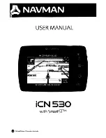
The full-screen Traditional sonar view show a large image of the
sonar readings from a transducer. The range scale along the
right side of the screen shows the depth of detected objects as
the screen scrolls from the right to the left.
À
Depth information
Á
Suspended targets or fish
Â
Bottom of the body of water
Garmin ClearVü Sonar View
NOTE:
To receive Garmin ClearVü scanning sonar, you need a
compatible chartplotter or fishfinder and a compatible
transducer.
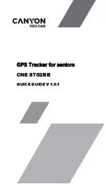
Garmin ClearVü high-frequency sonar provides a detailed
picture of the fishing environment around the boat in a detailed
representation of structures the boat is passing over.
Traditional transducers emit a conical beam. The Garmin
ClearVü scanning sonar technology emits two narrow beams,
similar to the shape of the beam in a copying machine. These
beams provide a clearer, picture-like image of what is beneath
the boat.
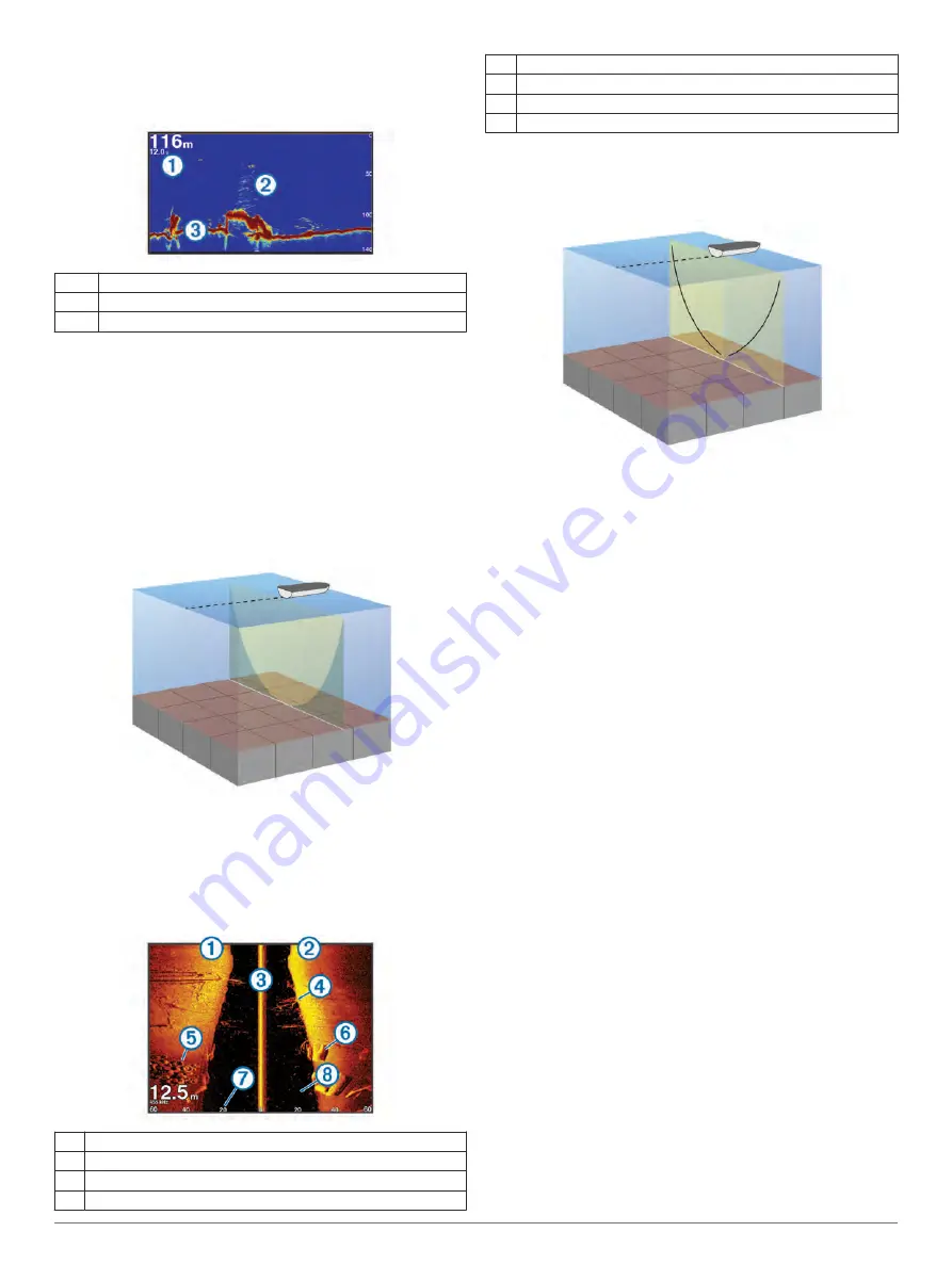
SideVü Sonar View
NOTE:
To receive SideVü scanning sonar, you need a
compatible sounder module and a compatible SideVü
transducer.
SideVü scanning sonar technology shows you a picture of what
lies to the sides of the boat. You can use this as a search tool to
find structures and fish.
À
Left side of the boat
Á
Right side of the boat
Â
The transducer on your vessel
Ã
Trees
Ä
Old tires
Å
Logs
Æ
Distance from the side of the boat
Ç
Water between the vessel and the bottom
SideVü Scanning Technology
Instead of a more common conical beam, the SideVü transducer
uses a flat beam to scan the water and bottom to the sides of
your boat.
Split-Zoom Sonar View
The split-zoom sonar view shows a full-view graph of sonar
readings, and a magnified portion of that graph, on the same
screen.
Split-Frequency Sonar View
In the split-frequency sonar view, one side of the screen shows
a full-view graph of high frequency sonar data, and the other
side of the screen shows a full-view graph of lower frequency
sonar data.
NOTE:
The split-frequency sonar view requires the use of a
dual-frequency transducer.
Panoptix Sonar Views
NOTE:
Not all models support Panoptix transducers.
To receive Panoptix sonar, you need a compatible chartplotter
and a compatible transducer.
The Panoptix sonar views allow you to see all around the boat in
real time. You can also watch your bait underwater and bait
schools in front of or below your boat.
The LiveVü sonar views provide you a view of the live
movement either in front of or below your boat. The screen
updates very quickly, producing sonar views that look more like
live video.
The RealVü 3D sonar views provide three-dimensional views of
either what is in front of or below your boat. The screen updates
with each sweep of the transducer.
To see all five Panoptix sonar views, you need one transducer
to show the down views and a second transducer to show the
forward views.
To access the Panoptix sonar views, select Sonar, and select a
view.
LiveVü Down Sonar View
This sonar view shows a two-dimensional view of what is below
the boat and can be used to see a bait ball and fish.
18
Sonar
Содержание GPSMAP 902 series
Страница 1: ...GPSMAP 702 902SERIES Owner sManual...