35
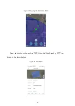
Select different sides (side 1 / side 2...), the planned route will be parallel to the
selected edge (orange light on). A safe distance can be set in each side, and the
safe distance can be set by tapping the increase and decrease buttons, or by
entering numbers directly.
Any vertex of the plot can be selected as the starting point of the route, and the
"S" and "E" on the track mark the starting point and the ending point of the route.
The user can tap on the map to select the point, and the remote control will plan
the starting point and the ending point according to the tapped place.
Tap
to open the "Intelligent Planning Mileage", and the route will divide the
whole plot into several sub-routes according to the designed mileage, and each sub-
route will execute corresponding return / hover action after the operation; if the
intelligent planning mileage is set to 0, the intelligent planning function will be closed,
as shown in the following figure.
Figure 25 Intelligent Planning Milea


