IFD400 Series Pilot Guide
3-20 Map Subsystem
Weather Data Legend
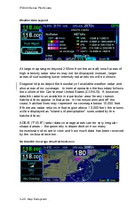
At large map ranges beyond 250nm from the aircraft, small areas of
high-intensity radar returns may not be displayed; instead, larger
areas of surrounding lower-intensity radar returns will be shown.
Diagonal stripes depict the boundary of available weather radar and
also areas of no-coverage. In normal operation the boundary follows
the outline of the Continental United States (CONUS). If, however,
datalink radar is unavailable in a particular area for any reason,
hatched lines appear in that area. In the mountains and off the
coast, hatched lines may represent no coverage below 10,000 feet.
If there are radar returns in that region above 10,000 feet, the returns
will be displayed as “islands of precipitation” surrounded by the
hatched lines.
ADS-B
(“FIS-B”) radar data coverage areas can be very irregular
shaped areas
– the geometry is dependent on how many
transmission sites are in view and how much data has been received
by the on-board receiver.
No Datalink Coverage Area Hatched Lines
Содержание IFD410 FMS/GPS
Страница 1: ......
Страница 8: ......
Страница 56: ......
Страница 100: ...IFD400 Series Pilot Guide 2 44 FMS Subsystem Info Tab Nearby Navaids ...
Страница 160: ......
Страница 250: ...IFD400 Series Pilot Guide 4 90 Aux Subsystem ADS B Unavailable Products Page ...
Страница 252: ......
Страница 378: ......

