


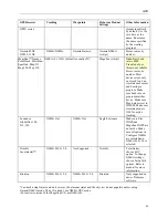


GPS
99
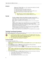
To Send Route Directions
Use the following steps to send route directions to your GPS device.
1.
Connect your GPS receiver to your computer.
2.
If you are using a third-party GPS receiver, you may have to use specific settings. For example, if you are
using a GARMIN GPS receiver, set your GARMIN receiver interface to GRMN/GRMN. For more
information, see your owner manual or
GPS Settings for Third-Party Devices
on page 92.
3.
Click the
GPS
tab, click
Settings
, and then click
Exchange
. The Exchange Wizard displays.
OR
Click the
Map Files
tab and then click
Exchange
. The Exchange Wizard displays.
4.
Under Device Type, select
GPS
.
5.
Select
Send to Device
.
6.
Select
Route Directions
from the Object drop-down list.
7.
Click
Next
.
8.
Designate a route name and/or a route number for the file on the device (device dependent).
9.
To avoid overwriting existing waypoints on your device, type a starting point for the new points and select
the Prefix a Number to the Waypoint Name check box.
Note
: Not all devices support starting points. See your device manual for more information.
10.
Click
Send to Device
.
11.
Repeat steps 8–10 for each route file you wan to send to your device.
12.
Click
Finish
.
Sending Draw Data to Your GPS Device
If you have a compatible GPS device, you can send draw data to your GPS device using the Exchange Wizard in
Street Atlas USA 2005.
To Send Draw Data to Your GPS Device
Use the following steps to send draw data to your GPS device.
1.
Connect your GPS receiver to your computer.
2.
If you are using a third-party GPS receiver, you may have to use specific settings. For example, if you are
using a GARMIN GPS receiver, set your GARMIN receiver interface to GRMN/GRMN. For more
information, see your owner manual or
GPS Settings for Third-Party Devices
on page 92.
3.
Click the
GPS
tab, click
Settings
, and then click
Exchange
. The Exchange Wizard displays.
OR
Click the
Map Files
tab and then click
Exchange
. The Exchange Wizard displays.
4.
Under Device Type, select
GPS
.
5.
Select
Send to Device
.
6.
Select
Draw Data
from the Object drop-down list.
7.
Click
Next
.
8.
To avoid overwriting existing waypoints on your device, type a starting point for the new points and select
the Prefix a Number to the Waypoint Name check box.
Note
: Not all devices support starting points. See your device manual for more information.
9.
Click
Send to Device
.
10.
Repeat steps 8–9 for every route file you want to send to your device.
11.
Click
Finish
.
Sending Waypoints to Your GPS Device
If you have a compatible GPS device, you can send waypoints to your GPS device using the Exchange Wizard in
Street Atlas USA 2005.
To Send Waypoints
Use the following steps to send waypoints to your GPS device.
1.
Connect your GPS receiver to your computer.
2.
If you are using a third-party GPS receiver, you may have to use specific settings. For example, if you are
using a GARMIN GPS receiver, set your GARMIN receiver interface to GRMN/GRMN. For more
information, see your owner manual or
GPS Settings for Third-Party Devices
on page 92.
Содержание Street Atlas USA 2005
Страница 1: ...Street Atlas USA 2005 User Guide...
Страница 2: ......
Страница 10: ......
Страница 25: ...Getting Started with Street Atlas USA 2005 15...
Страница 38: ......
Страница 58: ......
Страница 74: ......
Страница 114: ......
Страница 124: ......
Страница 132: ......
Страница 138: ......
Страница 140: ......
Страница 142: ......


