


7
94-0561-D
The SceneScan System is a high accuracy rotating laser Sensor that provides
positional information to allow automated approach and/or station keeping relative
to a structure or vessel. It is designed to be semi-portable and straightforward to
operate.
Its key elements are:
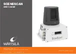
• The SceneScan Sensor: The marine grade SceneScan Sensor is mounted on the
vessel (typically on the wheelhouse) as required. The SceneScan Sensor emits
eye-safe infrared light and detects the reflections received back from one or more
designated structures or vessels.
• The SceneScan Client Software: There are two key pieces of software:
•
The SceneScan Service Interface: The SceneScan Service Interface is used for system
installation and maintenance.
•
The SceneScan Dashboard: The SceneScan Dashboard generates a visual representation of the
scene detected by the SceneScan Sensor. It gives the DP Operator control of the system and the
data stream being fed to the DP system.
Both pieces of software run under Windows™ on a Type 4 Marine Processor or other
computer providing the minimum system requirements (
see page 57
).
The SceneScan system operates differently to other local position reference systems
in that it does not require any type of target to be placed on the asset that is being
approached or used for station keeping.
It scans the vessel or structure and produces a map. This map is compared to the
current scan by the SceneScan Sensor navigation algorithm, which is used to track a
local position.
1.2
Introduction
1
System Overview
Summary of Contents for SCENESCAN
Page 82: ...94 0561 D...


