background image

Page 75

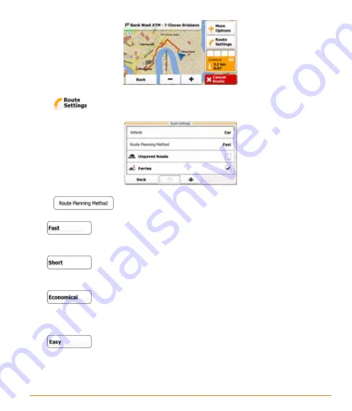
3. Tap 

.

4. Tap 

, and then tap one of the following:

  • 

 - Gives a quick route if you can travel at or near the speed limit  

    on all roads. Usually the best selection for fast and normal cars.

  • 

 - Gives a short route. Usually practical for pedestrians, cyclists  

    or slow vehicles.

  • 

 - Combines the benefits of Fast and Short: The software 


    calculates as if it were calculating the Fast route, but it takes other roads as  

    well to save fuel.

  • 

 - Results in a route with fewer turns and no difficult manoeuvres. 


    With this option, you can make your software to take, for example, the  

    motorway instead of series of smaller roads or streets.

Summary of Contents for TRAX4310

Page 1: ...TRAX4310 In Car Navigation...

Page 2: ...and start using your device right away This document is the detailed description of the navigation software You can easily discover your device while you are using it however we still recommend that y...

Page 3: ...avigation menu 16 2 2 Hardware buttons 17 2 3 Buttons and other controls on the screen 17 2 3 1 Using keyboards 19 2 3 2 Beyond single screen tap 20 2 4 Map screen 21 2 4 1 Navigating on the map 21 2...

Page 4: ...52 3 1 2 2 Selecting the destination from other Places of Interest by name 55 3 1 2 3 Selecting the destination from other Places of Interest by category 58 3 1 2 4 Selecting nearby assistance from W...

Page 5: ...4 Route calculation and recalculation 85 4 1 5 Road Safety Cameras 86 4 1 5 1 Camera types 86 4 1 5 2 Camera directions 88 4 1 6 Speed limit warning 88 4 1 7 Battery and GPS position quality indicato...

Page 6: ...d here is missing or damaged contact your place of purchase immediately TRAX4310 GPS navigation device Press the power button at the TOP of the device to turn the navigation on or off Owners Manual Qu...

Page 7: ...your car s cigarette lighter or any standard 12VDC 24VDC outlet Only use the power adapter that came with your device Any other adapter might damage the device Press and hold the power button at the t...

Page 8: ...lar tool 3 N A N A 4 Mini USB Port Charge the GPS device by connecting AC adaptor or car charger 5 Power Indicator The light is red during charging it will turn green when the battery is fully charged...

Page 9: ...the road for a few minutes It s a good idea to take valuable items with you when you leave you car that includes GPS devices If you can t take the device with you lock it in the glove compartment or...

Page 10: ...he Windshield mount 1 Loosen the locking collar on part 2 2 Push the ball joint of Part 1 through the locking collar into part 2 Insert the bracket hook into the notches at the bottom of the device Ro...

Page 11: ...en the locking collar to secure 4 Gently pull on the mount to make sure it is secure If you have trouble getting the suction cup to stick Clean the spot with an ammonia free cleanser Dry the spot comp...

Page 12: ...hicle we recommend that you operate your software before you start your journey Plan the route before your departure and stop if you need to change the route You must obey the traffic signs and follow...

Page 13: ...for the first time an initial setup process starts automatically Do as follows 1 Select the written language of the application interface Later you can change it in Regional settings page 97 2 Read an...

Page 14: ...in Route settings page 92 7 The initial setup is now complete Tap to proceed The Configuration wizard can be restarted later from the Settings menu page 91 8 You are offered to watch the Tutorial tha...

Page 15: ...f an address for example a street name without a house number or the names of two intersecting streets page 35 Enter an address with postal code page 48 This way you do not need to select the name of...

Page 16: ...the route in its full length on the map You can also perform route related actions such as cancelling your route picking route alternatives simulating navigation or adding the destination to your Favo...

Page 17: ...rn the device on again your software continues navigating as soon as the GPS receiver has determined your position 2 3 Buttons and other controls on the screen When you are using the software you usua...

Page 18: ...er the change the new value is shown on the button Tap it once Icon Shows status information Some icons also function as a button Tap them once List When you need to select from several options they a...

Page 19: ...xt and numbers Each key is a touch screen button 2 3 1 Using keyboards You only need to enter letters or numbers when you cannot avoid it You can type with your fingertips on the full screen keyboards...

Page 20: ...lts Tap Finalising the keyboard entry saving your input Tap Cancelling the keyboard entry returning to the previous screen Tap 2 3 2 Beyond single screen tap You usually need to tap the screen only on...

Page 21: ...list will scroll fast or slow only a bit or till the end Moving the map in map browsing mode grab the map and move it in the desired direction Shortcut to open the Map screen slide your finger from t...

Page 22: ...urrent position is available This map shows the current position the Vehimarker a blue arrow by default the recommended route an orange line and the surrounding map area There are screen buttons and d...

Page 23: ...given by the GPS receiver Shows the speed limit of the current road if the map contains it Shows the current time corrected with time zone offset The accurate time comes from the GPS satellites and th...

Page 24: ...e calculation cannot take into account traffic jams and other possible delays 2 4 2 Position markers 2 4 2 1 Vehimarker and Lock on Road When your GPS position is available the software marks your cur...

Page 25: ...The location of the Cursor can be used as the destination of the route 2 4 3 Objects on the map 2 4 3 1 Streets and roads The software shows the streets in a way that is similar to how the paper road...

Page 26: ...e The following table lists some of the frequently shown route events The same symbols are used in both fields Icon Description Turn left Turn right Turn back Bear right Turn sharp left Keep left Cont...

Page 27: ...need to take Where there is additional information available signposts substitute arrows Signposts are displayed at the top of the map The colour and style of the signposts are similar to the real on...

Page 28: ...y not be part of the original software or they may need additional activation They are only available in selected cities and countries Check www naviextras com for details 2 4 3 5 Elements of the acti...

Page 29: ...r avoid certain road types page 66 However when your software cannot avoid such roads the route will include them and it will show them in a colour that is different from the route colour 2 4 4 Manipu...

Page 30: ...iew angle of the map in 3D mode Tap the button once to modify the view in large steps or tap and hold the button to modify it continuously and smoothly Rotating left and right Changes the horizontal v...

Page 31: ...ction takes immediate effect The Map screen returns automatically Buttons in the middle row These buttons open new screens Work on those screens and when you get back here tap to return to the Map scr...

Page 32: ...ive view Buildings are suppressed The map is displayed in 2D top down view Button Function The zoom level of the map can be set Smart Zoom continuously zooms the map in and out This is a reference to...

Page 33: ...es after sunset before it becomes dark This button opens the list of Favourite destinations to select a new route destination This list can also be accessed from the Destination menu This button opens...

Page 34: ...Shows whether the position is current or the time left since it was last updated Besides these pieces of information you can search for assistance near your current position Tap to open a new screen...

Page 35: ...treet name without a house number or the names of two intersecting streets page 36 If you only know the street address and not the city town then see the tip on how to select ALL cities within the sta...

Page 36: ...enu tap the following buttons 3 By default the software proposes the country state and settlement where you are If needed tap the button with the name of the country enter the first few letters of the...

Page 37: ...d the city town you need The most likely city town name is always shown in the input field To accept it tap If the desired name does not show up the names that match the string appear in a list after...

Page 38: ...cters to open the list of results before it appears automatically tap Select the street from the list 7 Enter the house number 1 Tap 2 Enter the house number on the keyboard To enter letters tap 3 Tap...

Page 39: ...or tap and start your journey TIP If you know that you will use this destination frequently before tapping put the destination on the list of your Favourites first tap and then and save the location T...

Page 40: ...search for an address in all its states 4 If you need to change the state tap the button with the name of the state enter the first few letters of the state name and and select a different state from...

Page 41: ...yboard 3 Find the street you need The most likely street name is always shown in the input field To accept it tap If the desired name does not show up the names that match the string appear in a list...

Page 42: ...f you are on the Map screen tap to return to the Navigation menu 2 In the Navigation menu tap the following buttons 3 By default the software proposes the country state and settlement where you are If...

Page 43: ...city town or if you have changed the country state tap 2 Start entering the name of the city town on the keyboard 3 Find the city town you need The most likely city town name is always shown in the in...

Page 44: ...y street name is always shown in the input field To accept it tap If the desired name does not show up the names that match the string appear in a list after entering a couple of characters to open th...

Page 45: ...rs the map appears with the selected destination in the middle The route is automatically calculated Tap or to modify route parameters or tap and start your journey 3 1 1 4 Selecting a city town centr...

Page 46: ...where it stands without a state to search for an address in all its states 4 If you need to change the state tap the button with the name of the state enter the first few letters of the state name an...

Page 47: ...atically tap Select the city town from the list 6 Instead of entering the street name tap This way the centre of the displayed city town becomes the destination of the route 7 After a short summary of...

Page 48: ...ntry state and settlement where you are If needed tap the button with the name of the country enter the first few letters of the country name on the keyboard and select a different one from the list I...

Page 49: ...r does not show up open the list of results by tapping Select the postal code from the list 6 Enter the street name 1 Tap 2 Start entering the street name on the keyboard 3 Find the street you need Th...

Page 50: ...the address If the entered house number cannot be found the midpoint of the street is selected as the destination 8 After a short summary of the route parameters the map appears with the selected des...

Page 51: ...g an intersection Search first for the street with a less common or less usual name fewer letters are enough to find it If one of the streets is shorter search for that one first You can then find the...

Page 52: ...or a Place by its name you can search for a Place by its category In addition you can search for special services from the Where Am I screen 3 1 2 1 Selecting the destination from the Places of Intere...

Page 53: ...they are searched around the last known position If an active route exists parking lots are searched around the destination of the route If there is no active route destination is not selected they a...

Page 54: ...by the length of the necessary detour Normal Places are displayed with their blue category icon only while Places with extra details so called Rich POIs are marked with the logo of their data source...

Page 55: ...2 2 Selecting the destination from other Places of Interest by name You can search for Places of Interest by their names 1 If you are on the Map screen tap to return to the Navigation menu 2 In the Na...

Page 56: ...The result list will be ordered by the distance from the destination Tap to search along the active route and not around a given point This is useful when you search for a later stopover that results...

Page 57: ...ordered by their distance from the current position from the destination from the centre of the selected city town or by the length of the necessary detour Normal Places are displayed with their blue...

Page 58: ...fter a short summary of the route parameters the map appears with the selected destination in the middle The route is automatically calculated Tap or to modify route parameters or tap and start your j...

Page 59: ...own The result list will be ordered by the distance from the centre of the selected city town Tap to search for a place around the destination of the active route The result list will be ordered by th...

Page 60: ...g Accommodation or tap to list all Places around the selected location or along the route 8 Select one of the main Place subcategories e g Hotel or Motel or tap to list all Places in the selected main...

Page 61: ...th of the necessary detour Normal Places are displayed with their blue category icon only while Places with extra details so called Rich POIs are marked with the logo of their data source If needed ta...

Page 62: ...p appears with the selected destination in the middle The route is automatically calculated Tap or to modify route parameters or tap and start your journey 3 1 2 4 Selecting nearby assistance from Whe...

Page 63: ...e stations Cash dispensers 4 Tap any of the quick search buttons to get an instant list of that type of Places 5 The Places in the list are ordered by their distance from the current position from the...

Page 64: ...turn to the basic details 7 Tap to select the displayed Place of Interest as the destination of the route 8 After a short summary of the route parameters the map appears with the selected destination...

Page 65: ...map move and scale the map as needed 4 Tap the location that you want to select as your destination The Cursor appears 5 Tap to select the displayed Place of Interest as the destination of the route...

Page 66: ...the Map screen tap the map to open the Quick menu If you are in the Navigation menu tap 2 Tap The list of Favourite destinations is displayed 3 Select the Favourite that you want to set as your desti...

Page 67: ...e the current time of day the day of week and the current location The more you use the navigation software the better it can guess your desired destination 1 If you are on the Map screen tap to retur...

Page 68: ...p to return to the Navigation menu 2 In the Navigation menu tap 3 Tap 4 The list of recent destinations appear Smart History promotes three destinations to the first page based on your previous routes...

Page 69: ...ated Tap or to modify route parameters or tap and start your journey 3 2 Viewing the entire route on the map It is easy to get a map overview of the active route Do as follows 1 If you are on the Map...

Page 70: ...iew facing North Additional information and controls are displayed around the map 3 The following pieces of information are displayed The active route is displayed it in its full length on the map The...

Page 71: ...Tap to change route parameters Tap to delete the active route Tap or to scale the map Tap to return to the Navigation menu 3 4 Modifying the route When navigation is already started there are several...

Page 72: ...time and distance you can turn off the GPS receiver Then you can set the starting point of the route to a different location than the current GPS position 1 If you are on the Map screen tap to return...

Page 73: ...an active route already existed it is now recalculated starting from the selected location 7 optional Tap to modify the route or to check its parameters 8 To return to normal navigation tap 3 4 3 Paus...

Page 74: ...with additional information and controls 3 Tap 4 Tap to confirm 3 4 5 Changing the route planning method To recalculate the active route with a different route planning method do as follows These cha...

Page 75: ...te Usually practical for pedestrians cyclists or slow vehicles Combines the benefits of Fast and Short The software calculates as if it were calculating the Fast route but it takes other roads as well...

Page 76: ...If you are on the Map screen tap to return to the Navigation menu 2 In the Navigation menu tap The active route is displayed it in its full length on the map together with additional information and c...

Page 77: ...this option you can make your software to take for example the motorway instead of series of smaller roads or streets 5 Tap to return to the previous screen and your software recalculates the route wi...

Page 78: ...Page 78 3 Tap 4 Tap and then tap one of the following 5 The software recalculates the route optimised for the new vehicle type The orange line now shows the new recommended route...

Page 79: ...e with different road type preferences do as follows These changes can also be made in Settings page 92 1 If you are on the Map screen tap to return to the Navigation menu 2 In the Navigation menu tap...

Page 80: ...ou might also need to pay a fare on ferries The software includes toll roads pay roads where there is a per use charge in the routes by default If you disable toll roads your software plans the best t...

Page 81: ...Page 81 3 Tap 4 Tap Using the keyboard enter a name for the Favourite Tap to enter numbers or symbols 5 Tap to save the location as a new Favourite destination...

Page 82: ...on the Map screen tap to return to the Navigation menu 2 In the Navigation menu tap The active route is displayed it in its full length on the map together with additional information and controls 3...

Page 83: ...g the simulation the control buttons disappear after a few seconds but you can open them again if you tap the map Jump to the next route event manoeuvre Pause the simulation Jump to the previous route...

Page 84: ...igh speed 4 1 2 Daytime and night colour themes The software uses different colour themes during the day and during the night for both the map and the menu screens Daytime colours are similar to paper...

Page 85: ...aytime or night colour theme currently used After leaving the tunnel the original colours return 4 1 4 Route calculation and recalculation Your software calculates the route based on your preferences...

Page 86: ...ase of Road Safety Cameras Yes Can Road Safety Camera locations be uploaded in a text file Yes Can you save the Cursor as the location of a Road Safety Camera No 4 1 5 1 Camera types There are differe...

Page 87: ...he warning stays on and your average speed is measured until you reach another speed camera of this type If your average speed exceeds the speed limit between the two speed cameras you receive the sam...

Page 88: ...on the map When you exceed the speed limit a symbol with the speed limit appears in the corner of the map for example Furthermore you can turn on an audible warning a voice message is played using th...

Page 89: ...al circumstances The software is connected to the GPS receiver but the signal is too weak and the receiver cannot determine the GPS position GPS navigation is not possible Only a few satellites are re...

Page 90: ...eed to get an activation key for the application kit Read the Tutorial to get instant understanding of the functions of your software or run the Demo to watch sample route simulations to see how navig...

Page 91: ...planning method Adjust the sound volume mute your device or enable warnings Replace the current Vehimarker position arrow with a vehicle or pedestrian image Set daytime and night colour themes for the...

Page 92: ...o account in route calculation The route calculation can be optimised for different situations and vehicle types by changing the planning method See below for details To let the route fit your needs y...

Page 93: ...e route The software includes ferries in a planned route by default However a map does not necessarily contain information about the accessibility of temporary ferries You might also need to pay a far...

Page 94: ...ul warnings Button Description Master Volume slider Adjusts the sound volume of the device All sounds of the application are affected Use the switch to mute all sounds of the device and then to re ena...

Page 95: ...on the Map screen while you are approaching one of these cameras This button is not displayed when GPS position is not available or if you are in certain countries where Road Safety Camera warning is...

Page 96: ...get more Vehimarkers at www naviextras com 4 3 4 Colour themes You can fine tune the appearance of the Map screen and the menus Choose suitable colour themes from the list for both daytime and night u...

Page 97: ...refer Button Description This button displays the current written language of the user interface By tapping the button you can select a new language from the list of available languages The applicatio...

Page 98: ...fset to obtain the desired time Select between 12 and 24 hours time display format You can set the distance units to be used by the program your software may not support all the listed units in some v...

Page 99: ...active and the preinstalled inactive content items activation needed at www naviextras com are listed Inactive content items are displayed in red Tap in the More menu to buy activation keys for the i...

Page 100: ...f the settlement but an arbitrary point the map creators have chosen In towns and villages it is usually the most important intersection in larger cities it is one of the important intersections Colou...

Page 101: ...ces North This is the orientation for example in Find on Map See also Track up map orientation Road Safety Camera A special Place of Interest type for speed cameras and red light cameras Different dat...

Page 102: ...ion is shown with a blue arrowarrow on the map by default The direction of the blue arrow shows the current heading This position marker can be replaced with different vehicle and pedestrian symbols Y...

Page 103: ...are into a vehicle pressing of the Accept button displayed by the software during installation or use hereinafter referred to as Use shall mean that the User has accepted the terms and conditions of t...

Page 104: ...duct and to its parts separately as well 5 3 The owner s of the copyrights of the Database forming part of the Software Product is are the natural person s or corporate entity ies listed in the Append...

Page 105: ...duplicate the Software Product to make a copy thereof 7 1 2 to lease rent or lend it or to transfer it to a third person for any reason 7 1 3 to translate the Software Product including translation c...

Page 106: ...does not provide a warranty for the Software Product being completely error free and the Licensor is not bound by any contractual obligation whereby the Software Product obtained by the User should b...

Page 107: ...expense of the person in breach 9 1 4 claim the return of the increase of assets due to the breach 9 1 5 demand the cease of the wrongful action and demand restitution to its state before the breach...

Page 108: ...4 Contents and services provided by the Licensor or an agent of the Licensor The Licensor or a contractual partner may offer various products and services to the User through www naviextras com The U...

Page 109: ...rranty to the original retail owner only shall terminate and be of no further effect ONE 1 year after the date of original retail sale This warranty will be deemed invalid if the product is A Damaged...

Page 110: ...not in any way affect your rights under the TRADE PRACTICES ACT 1974 Cth Australia or the CONSUMER GUARANTEES ACT New Zealand PROCEDURE FOR OBTAINING PERFORMANCE OR WARRANTY In the event that the prod...

Page 111: ...Page 111 Notes...

Page 112: ...Thank you for buying a Uniden product 2009 Uniden Australia Pty Limited Uniden New Zealand Ltd Printed in PRC...

Reviews: