


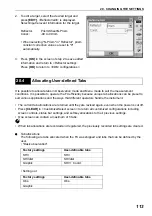


105
20. CHANGING THE SETTINGS
Tilt crn (tilt correction)
&
:
Yes (H,V)*, No, Yes (V)
Tilt error:
No action*/Go to Tilt screen
Coll.crn. (collimation correction)
&
:
No, Yes*
C&R crn.:
No, Yes(K=0.142),Yes(K=0.20)*
V manual:
No*, Yes
V.obs (vertical angle display method)
&
:Zenith*, Horiz., Horiz ±90
Coordinates:
N-E-Z*, E-N-Z
Sea level crn. (Sea level correction)
&
: Yes, No*
Ang.reso. (Angle resolution):
FX-101/FX-102: 0.5", 1"*
FX-103/FX-105/FX-107: 1"*, 5"
ppm setting:
Press, Temp.*, +Humidity
&
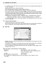
Hdist
The FX calculates horizontal distance using slope distance values. Horizontal distance display
can be selected from the following methods.
Grand:
Distance without sea level correction
Grid:
Distance on the rectangular coordinates system calculated by sea level
correction
(When "Sea level crn." is set to "No", Distance on the rectangular
coordinates system without correction)
&
Automatic tilt angle compensation mechanism
The vertical and horizontal angles are automatically compensated for small tilt errors using the
2-axis tilt sensor.
•Read the automatically compensated angles when the display has stabilized.
•The horizontal angle error (vertical axis error) fluctuates according to the vertical axis, so when
the instrument is not completely leveled, changing the vertical angle by rotating the telescope
will cause the displayed horizontal angle value to change.
•Compensated horizontal angle = Measured horizontal angle + Tilt in angle/tan (Vertical angle)
•When the telescope is directed close to the zenith or nadir angle, tilt compensation is not
applied to the horizontal angle.
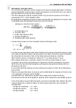
Mean sea level
Plane rectangular
coordinates system
Projection
distance
Ground
Grid
Slope distance


