


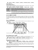


45
User Manual
option); ICON+DEPTH (the object icon and tag is visible, in the range selected
from “Underwater Object Depth Value” option).
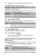
3.4
DISPLAY MENU
To allow you to change how the chart plotter displays information. It is possible to
select this menu only from the Chart Display page or the Depth Graph page in
split mode.
[MENU] + [MENU] + "DISPLAY" + [ENTER]
Auto Info
: Allows displaying information on cartographic object when the cursor is placed on it. The
Automatic Info On Points shows information when the cursor is placed on points (as Port
Services, Tides, lights, wrecks, rocks, buoys, beacons, obstructions, land markers, etc.). The
Automatic Info On All shows information when the cursor is placed on points, on lines (as Depth
contours, Traffic Separation, Territorial Sea, Cartographic Lines etc.) on areas (Depth, Built-up,
Sea, Attention, Restricted etc.) and on names (on the beginning of the text -hot spot- or on any
of the characters of the name -name message box-). The details on Land, Source of Data,
Cartographic Area and Spot Soundings are not shown.
Screen Amplifier
: In Home mode the Screen Amplifier (Look Ahead) function sets up the charts on the navigation
direction (course) in order to display more map details in front of the vessel’s position.
Course Line
: Selects the value among Off/2/10/30 Min/1/2 hours/Infinite.The Course Line is a graphical
indication of the direction in which the Vessel is heading. The Course Line origin is the vessel’s
position so the time line movement is synchronized with the vessels Icon. Course Line "course"
is given by the value of COG (Course Over Ground) and its length is proportional to the SOG
(Speed Over Ground).
Ship Icon Mode
: Sets the Ship Icon Mode between Steady or Blinking. When Ship Icon Mode is Blinking, the ship
icon (and the heading line) blinks every 1 second, otherwise when it is Steady the Ship Icon (and
the heading line) does not blink.
Coordinates System
: If TD is selected as Coordinate System, a new menu appears on the screen to set Chain, Pair,
ASF 1/2, Alternate Solution.
Map Datum
: Allows selecting any Geodetic Datum reference from the over 100 available on the chart plotter.
Map Datum selection switches to the selected reference datum applying the datum offsets
stored with the charts.
Fix Datum
: Sets the datum reference used by the GPS receiver connected to (or integrated in) the chart
plotter so that the chart plotter converts the position received from the GPS to the Map Datum
currently selected in the menu in order to match the position from the GPS with the position on
the charts. You must know what datum reference is used by the GPS and set it in the Fix Datum option.
External WPT
: The coordinates of a Waypoint, received from a GPS connected to the chart plotter, can be
stored into the chart plotter, if the GPS is NMEA-0183 protocol compatible and support the
$BWC sentence (this symbol remains on the screen for 30 seconds). You may save it by placing
a Waypoint or a Mark onto that symbol. As soon as the chart plotter receives another $BWC
sentence with the coordinates of a new Waypoint, the symbol moves to the new point.
User Points
: Sets On (icon + label), Off or Icon (only icon) the displaying of User Point.
Symbol Size
: Sets Normal or Small the icon of User Point.
Data Window Mode
: Customizes the Text Area layout: it is possible to customize the Text Area layout among Full
Screen, Vertical, Text Area with 5 boxes and Text Area with 8 boxes (for Text Area with 5 boxes
and Text Area with 8 boxes you can select between Small or Large boxes size).
Cursor Window
: Enables or disables the display of the cursor window on the screen.
COLOR MAX 15:
Event Handler Type
: Selects the type as Normal or By Key. Selecting Normal allows placing the Event with a
default name; selecting By Key allows setting the desired number for the Event. The default
setting is Normal.
Position Symbol
: Selects the icon of the fix position displayed on the screen between Boat and Standard. The
default setting is Boat.
3.5
VIDEO INPUT MENU
By accessing this menu it is possible to see images on the chart plotter display
captured from an external video signal source, if connected to the chart plotter.
Not all color chart plotters are connectable to the external video signal. Please
make sure that your chart plotter is equipped with a video input connection port.
Summary of Contents for COLOR MAX 15
Page 20: ...22 User Manual...
Page 56: ...58 User Manual...
Page 58: ...60 User Manual...
Page 78: ...80 User Manual...
Page 84: ...86 User Manual...
Page 96: ...98 User Manual...


