background image

143

Section 10:

Searching

NOTE:

The background map loaded in your unit lets you search for high-
ways and arterial streets in the U.S., as well as land features, in-
cluding cities and lakes. For a complete description of what detail is
found in the background map, see page 89.

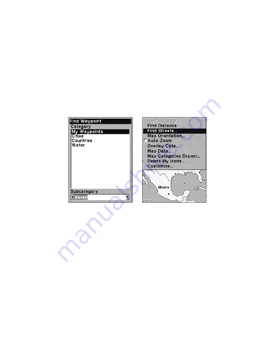
The unit's search functions all begin with either the Find Waypoint
menu or the Map Page menu. Press 

WPT

 and the Find Waypoint menu

appears for waypoints and land features. From the Map Page, press

MENU

 and the Map Page menu appears for streets and intersections.


Find Waypoint menu, left and Map Page menu, right.

NOTE:

You can search for items even if the unit hasn't acquired a position
yet, or start from a position other than your own. When you do a
search, distance and bearing to the selected item will be calculated
from the unit's current position. If the unit hasn't acquired a posi-
tion, it will use the last known position. If the cursor is active, the
unit will 

always

 begin the search at the cursor. You can look up

items by name, or search for the item nearest to you.

Find Any Item Selected by Map Cursor

On the Map Page: with a map feature selected by the cursor press 

WPT

.

To return to the previous page, press 

EXIT

.

Summary of Contents for M68C IceMachine

Page 1: ...Pub 988 0152 031 www lowrance com M68C S Map M68C IceMachine Fish finding Sonar Mapping GPS Installation and Operation Instructions...

Page 2: ...d it necessary to change or end our policies regulations and special offers at any time We reserve the right to do so without notice All features and specifications subject to change without notice Al...

Page 3: ...r Bracket Installation 16 Transducer Orientation and Fish Arches 17 Shoot Thru Hull Preparation and Installation 18 Power and Cable Connections 22 Mounting the Sonar Unit In Dash or Bracket 23 Portabl...

Page 4: ...y Options 61 Full Sonar Chart 61 Split Zoom Sonar Chart 61 Digital Data Chart 62 Flasher 62 Sonar Simulator 63 Stop Chart 63 Surface Clarity 64 Zoom Pan 65 Sec 5 Ice Fishing 67 Icemachine Mode Operati...

Page 5: ...vigating Trails 101 Visual Trailing 102 Navigate a Trail Forward 102 Navigate a Back Trail Backtrack or Reverse 104 Cancel Navigation 105 Sec 8 Advanced GPS Operations 107 Find Distance from Current P...

Page 6: ...imulating Trail or Route Navigation 126 Initialize GPS 126 Map Auto Zoom 127 Map Data 127 Earth Map Detail 127 Pop Up Map Info 128 Fill Water with White 128 Map Overlays Range Rings Lat Long Grid 128...

Page 7: ...the waypoint regardless of obstructions Therefore the prudent navigator will not only take advantage of all available navigation tools when traveling to a way point but will also visually check to ma...

Page 8: ...vi Notes...

Page 9: ...h we ll show you how and where to skip ahead for the next important topic We ve also made it easy to look up any tips you may need from time to time Here s how The manual is organized into 11 sections...

Page 10: ...e screen you can look it up in the manual by skimming over the table of contents or index just flipping through Section 7 or scanning through the command portion of Section 8 This unit is ready to use...

Page 11: ...u languages selectable by user Sonar Frequency 200 kHz Transducer A Skimmer transducer comes packed with your sonar unit Its 20 cone angle offers a wide fish detection area of up to 60 with high sensi...

Page 12: ...ormation contact the factory s Customer Service Department phone numbers are listed on the last page How Your Sonar Works Sonar has been around since the 1940s so if you already know how it works skip...

Page 13: ...couple of dozen GPS satellites circling the earth It will also listen in to the WAAS satellites in orbit but more about that in the upcoming segment introducing you to GPS and WAAS Your unit listens t...

Page 14: ...s above the Earth passing overhead twice daily A series of ground stations with precisely surveyed locations controls the satellites and monitors their exact loca tions in the sky Each satellite broad...

Page 15: ...o not yet receive robust WAAS coverage Continued WAAS development is planned to extend WAAS coverage in the years to come WAAS boosts the accuracy of land GPS navigation but the system is designed for...

Page 16: ...n of some kind with the menu item Text that you may need to enter or file names you need to select are show in italic type such as trail name Instructions Menu Sequences Most functions you perform wit...

Page 17: ...wer cable from the unit s location to an appropriate power source and connect it there 6 Connect the transducer power cable to the unit and mount the so nar GPS unit to the bracket Transducer Installa...

Page 18: ...d a paper plate or piece of cardboard to mix the epoxy on Supplies rubbing alcohol 100 grit sandpaper specially formulated epoxy adhesive available from LEI see ordering information on the inside back...

Page 19: ...transducer cable away from other wiring on the boat Electrical noise from engine wiring bilge pumps and aerators can be displayed on the sonar s screen Use caution when routing the transducer cable ar...

Page 20: ...In a shoot thru hull installation the transducer is bonded to the inside of the hull with epoxy The sonar ping signal actually passes through the hull and into the water This differs from a bolt thru...

Page 21: ...if you can move the transducer so that it s parallel with the ground 1 Assembling the bracket Press the two small plastic ratchets into the sides of the metal bracket as shown in the following illustr...

Page 22: ...for the ratchets assemble the transducer as shown in the fol lowing figure Don t tighten the lock nut at this time Assemble transducer and bracket 4 Drilling mounting holes Hold the transducer and br...

Page 23: ...ducer to the transom Slide the transducer up or down until it s aligned properly with the bottom of the hull as shown in the preceding and following figures Tighten the bracket s mount ing screws seal...

Page 24: ...seal the hole with the same marine grade above or below waterline seal ant adhesive used for the mounting screws 7 Make a test run to determine the results If the bottom is lost at high speed or if no...

Page 25: ...trans ducer is ready for use Transducer mounted on trolling motor side view TRANSDUCER ORIENTATION AND FISH ARCHES If you do not get good fish arches on your display it could be because the transduce...

Page 26: ...hosen area See the figure below WARNING Do not remove any material from your inner hull unless you know the hull s composition Careless grinding or cutting on your hull can result in damage that could...

Page 27: ...the boat Plug the transducer into the sonar unit turn it on then hold the transducer over the side of the boat in the water Adjust the sensitivity and range controls until a second bottom echo is see...

Page 28: ...gnal 4 Most people can get good results by following steps 1 through 3 so this step is optional If you want to make an extra effort to be absolutely sure that your selected location will work under al...

Page 29: ...a thin layer of epoxy about 1 16 or 1 5 mm thick on the face of the transducer as shown in the previous figure Make sure there are no air pockets in the epoxy layer Then apply the remaining ep oxy to...

Page 30: ...it s power socket In saltwater environments we recommend you connect the power cable to the auxiliary power switch included in most boat designs If that results in electrical interference or if such a...

Page 31: ...l devices this unit could be damaged to a point that it is unrepairable and could even cause harm to the user when not properly fused CAUTION Failure to use the enclosed 3 amp fuse will void your warr...

Page 32: ...ng You may need to place a piece of plywood on the back side of thin pan els to reinforce the panel and secure the mounting hardware Drill a 5 8 15 9 mm hole in the dash for the power transducer cable...

Page 33: ...r tilting the unit and attaching the connector The snug fit of the push on water proof connector requires some force to attach Also be sure there is enough cable slack for rotation if you decide to us...

Page 34: ...the bracket as you lower it into position As you push down the unit will lock into place with a distinct click To adjust the viewing angle pinch the ratchets with one hand then tilt the unit with you...

Page 35: ...t includes a rechargeable gel cell battery and a transducer designed for stationary use The entire rig is contained in a carry bag that fits inside a five gallon plastic bucket The PPP 12 package incl...

Page 36: ...le Power Pack with a sonar unit stowed for transport Turn the unit on If it doesn t work make sure the battery terminals are making good contact against the battery contacts Also check the wiring conn...

Page 37: ...the nut onto it Screw the suction cup onto the bracket using the supplied screw and flat washer Tie the nylon cord through the hole in the top of the bracket When using this transducer tie the other e...

Page 38: ...led move on to Sec 3 Basic Sonar Operations There we ll present a series of step by step tutorials to teach you the basics of your sonar operation NOTE When you first turn the unit on the Map Page app...

Page 39: ...ec 7 1 PWR LIGHT Power Light The PWR key turns the unit on and off and activates the backlight 2 PAGES Pressing this and the arrow keys 4 switches the unit be tween the different page display screens...

Page 40: ...otter Page zooming in lets you see greater detail in a smaller geographic area on the display Memory This unit has permanent memory that saves all user settings even when power is removed It does not...

Page 41: ...igation command turns off the various navigation com mands Used to stop navigating after you have reached your destina tion waypoint Point of Interest or map cursor location or after you reach the end...

Page 42: ...Menu commands include ColorLine command separates fish and structure near the bottom from the actual bottom and defines bottom composition hardness Depth Range command manually sets the depth range sh...

Page 43: ...are the Full Sonar Chart Split Zoom Sonar Chart Digital Data and Flasher You access the various display modes by pressing the PAGES key then pressing to SONAR or to desired page ENT The Full Sonar Ch...

Page 44: ...yed in many ways We ll discuss all of those features and options in the Advanced Sonar Operation section but to show you how easy the sonar unit is to operate the following page contains a simplified...

Page 45: ...l filter out some information but could omit important images We recommend adjusting sensitivity until the background is lightly peppered that is scattered dots ap pear but individual objects like fis...

Page 46: ...creasing the sensitivity a little at a time There are situations when too much clutter appears on the screen Decreasing the sensitivity can reduce the clutter and show the strongest fish ech oes if fi...

Page 47: ...turned on the unit will continue to track the bottom and make minor adjustments to the sen sitivity level with a bias toward the setting you selected Adjusting sensitivity in Manual Sensitivity Mode...

Page 48: ...sh I D fish symbol feature Here s why Fish I D is an easier way for a sonar novice to recognize a fishy signal return when he sees it However locating fish by symbol only has some limitations Your son...

Page 49: ...akes a great supplement to this operation manual For the ultimate training aid be sure to download the free emulator software for your unit Aside from being just plain fun this program can help you le...

Page 50: ...42 Notes...

Page 51: ...f the transducer even vibration from the engine In all cases noise can produce unwanted marks on the display The ASP feature has four settings Off Low Medium and High If you have high noise levels try...

Page 52: ...rms The depth alarms sound a tone when the bottom signal goes shallower than the shallow alarm s setting or deeper than the deep alarm s set ting For example if you set the shallow alarm to 10 feet th...

Page 53: ...press ENT 4 Press to DEEP ALARM ENABLED ENT EXIT 5 To turn off the alarm press MENU MENU to ALARMS ENT to SONAR ALARMS ENT to DEEP ALARM ENABLED ENT EXIT To switch to a different depth setting open t...

Page 54: ...ENT EXIT EXIT EXIT To switch to a different depth setting open the Sonar Alarms menu and repeat the instructions in steps 3 and 4 above Fish Alarm Use the fish alarm for a distinctive audible alarm w...

Page 55: ...art speed may result in a shorter line that more closely resembles a regular fish return At left Sonar Page menu with Chart Speed command selected At right Chart Speed Control Bar If you do experiment...

Page 56: ...sh from structure ColorLine is adjustable Experiment with your unit to find the Color Line setting that s best for you At left Sonar Page menu with ColorLine command selected At right the ColorLine co...

Page 57: ...int the depth of a target 1 From the Sonar Page press MENU to DEPTH CURSOR ENT 2 The depth cursor appears Press to lower the cursor line press to raise the cursor line 3 To clear the depth cursor pres...

Page 58: ...ress to DEPTH RANGE ENT and the Depth Range Control Scale appears 3 Press or to select a different depth range A horizontal dark bar highlights the selected range 4 When the new range is selected pres...

Page 59: ...upper and lower limits 1 From the Sonar Page press MENU to UPPER AND LOWER LIMITS ENT The Sonar Chart Limits menu appears with Upper Limit selected 2 To set the upper limit press ENT Press or until th...

Page 60: ...onditions as fish The microcomputer analyzes all echoes and eliminates surface clutter thermoclines and other signals that are undesirable In most instances remaining targets are fish The Fish I D fea...

Page 61: ...eatures menu with Fish I D Symbols selected When the check box to the left is checked the feature is on To turn the Fish I D feature on 1 From the Sonar Page press MENU to SONAR FEATURES ENT 2 Press t...

Page 62: ...n Advanced Signal Processing in this section Overlay Data To change the digital data shown on top of the sonar page 1 Press MENU to OVERLAY DATA ENT 2 Press or to select Data Type ENT Overlay Data com...

Page 63: ...revious page press EXIT EXIT To change displayed data font size 1 Press MENU to OVERLAY DATA ENT 2 Press or to select Data Type The DATA SIZE displayed in the bot tom of the Overlay Data Shown window...

Page 64: ...nd chart scroll speed can keep pace with the boat as it moves quickly over the bottom terrain When using HyperScroll you may also need to manually decrease the sensitivity for optimum performance Depe...

Page 65: ...Scroll the width of the FasTrack bar graph display doubles in width at the right side of the screen This allows you to better see the virtually instantaneous sonar returns just as you would on a flash...

Page 66: ...tail However situations occur when it becomes necessary to increase or de crease the sensitivity This typically happens when you wish to see more detail so an increase in sensitivity is indicated Or w...

Page 67: ...ual mode the Reset Options command will switch back to Auto and re set the factory setting at the same time Tip For quicker sensitivity adjustments try leaving the Sensitivity Control Bar on the scree...

Page 68: ...EXIT The depth indicators now accurately show the depth of water beneath the keel NOTE If knowing the exact depth of water beneath the keel is less impor tant you can calibrate the depth indicators so...

Page 69: ...the screen represents the surface The bottom depth and surface temperature if the unit is equipped with a temperature sensor or a transducer with a temp sensor built in show at the top left corner of...

Page 70: ...t This mode shows seven digital data boxes or windows containing by de fault Water Depth Water Temp Temp 2 Track Distance to Destination Speed and the unit s Voltage Digital Data Chart Flasher The Fla...

Page 71: ...may enter a demo mode The words demo mode in a pop up box flash in the middle of the screen and a sonar chart plays much like the simula tor Unlike the simulator the demo mode is for demonstration onl...

Page 72: ...tion boat wakes temperature inversion and more The surface clarity control reduces or eliminates surface clutter signals from the display It does this by changing the sensitivity of the receiver decre...

Page 73: ...g on the 2X zoom will show all echoes that are be tween the top and bottom of the 2X zoom bar The 4X zoom will show only the echoes between the top and bottom of the 4X zoom bar To switch the zoom 1 P...

Page 74: ...nting your zoom at different portions of the chart as it scrolls you can get a good close up look at structure or cover below you To use Zoom Pan switch to a manual depth Range setting see page 50 and...

Page 75: ...Temp 2 The ice fishing transducer does not contain a temp sensor so only one temperature reading can be displayed while ice fishing This requires the purchase of the optional TS 2U temp sensor This m...

Page 76: ...flasher screen The Split Zoom and Sonar Chart pages share the same settings The chart pages the Flasher and Ice Flasher pages each have their own independent controls for Sensitivity ColorLine and son...

Page 77: ...onar Chart is shown To enter the IceMachine mode 1 From the Full Chart Sonar page press ENT ENT ENT to switch to the normal Flasher page 2 Press MENU to ICEMACHINE MODE ENT EXIT and the Ice Flasher ap...

Page 78: ...he automatic factory default settings until you get a feel for how it s working As you re learning the basics however Sensitivity is the one important setting that you should adjust while ice fishing...

Page 79: ...re flected in the Echo Strength Color Scale This scale considers both sen sitivity and ColorLine and then shows you the relationship of signal strength to signal color To adjust the ColorLine level 1...

Page 80: ...ettings and then recharge the battery This battery gauge is solid green indicating a full charge Sonar Signal Interpretation When you monitor your flasher screen for signs of fish there are three sign...

Page 81: ...As fish size increases the ech oes grow stronger and the signal band grows wider Signal width also increases as a fish approaches the center of the sonar cone Ice Flasher Options Split Zoom Display M...

Page 82: ...e bottom target separation with Split Zoom mode Color Modes Sonar Color Mode is described in detail in Sec 4 The ice fishing fea tures have expanded the number of options and how the color modes are c...

Page 83: ...ss EXIT EXIT to return to the flasher page At left Ice Flasher menu with Flasher Options selected Center Flasher Options menu with Flasher Color Mode selected At right Nightview color option is select...

Page 84: ...ers requires a small plastic bag such as a food storage bag They fill the bag with a mixture of RV anti freeze and water The bag is placed on the ice surface and the trans ducer is rested in the puddl...

Page 85: ...cal wiring on the boat may help Route the sonar unit s power cable directly to the battery instead of through a fuse block or ignition switch 2 Inspect the transducer cable for breaks cuts or pinched...

Page 86: ...nit to eliminate weaker signals such as fish or even structure from the display Try using resis tor spark plugs or routing the sonar unit s power and transducer cables away from other electrical wirin...

Page 87: ...r s wires away from it You may need to route the sonar unit s power cable directly to the battery to isolate it from other wiring on the boat If no noise displays on the sonar unit from electrical equ...

Page 88: ...80 Notes...

Page 89: ...rk together BUT if you just can t wait to get outside turn to the one page Quick Reference on page 91 Keyboard Lowrance M68 close up of unit s keyboard 1 PWR Power The PWR key turns the unit on and of...

Page 90: ...ou zoom the screen in On the Sonar Page this key enlarges fish signals and bottom detail On the Full Map display zooming in lets you see greater detail in a smaller geographic area on the display Powe...

Page 91: ...route My Trails command shows hides creates and deletes plot trails Also used to navigate or backtrack a trail Cancel Navigation command turns off the various navigation com mands Used to stop navigat...

Page 92: ...he bottom The Sonar Page is discussed in detail in Sec 3 To get to the Sonar Page Press PAGES to SONAR EXIT Satellite Status Page The Satellite Status GPS Page shown in the following images provides d...

Page 93: ...er is dark blue therefore it isn t being used to solve the position Beneath the circular graph are the bar graphs one for each satellite in view Since the unit has twelve channels it can dedicate one...

Page 94: ...on of travel you are taking Navigation Page recording a trail traveling northwest Page looks like this when the unit is not navigating to a waypoint following a route or backtracking a trail When navi...

Page 95: ...se to the side of the desired course line The course line is an imaginary line drawn from your position when you started navigating to the destination waypoint The course line is shown on the Navigati...

Page 96: ...from a bird s eye view By default this unit shows the map with north always at the top of the screen This can be changed See the topic Map Orientation in Sec 9 If you re navigating to a waypoint the m...

Page 97: ...unty boundaries some major city streets Inter state U S and state highways lakes and streams and more than 60 000 navigation aids and 10 000 wrecks and obstructions in U S coastal and Great Lakes wate...

Page 98: ...nu 3 To change the window size again or revert back to the original dis play just follow the steps above Most dual window displays use half the screen for each window by default You can also use the R...

Page 99: ...eater detail press ZIN zoom in key Zoom out to see more area less detail press ZOUT zoom out key Scroll display north south east or west using arrow keys To stop scrolling clear cursor and return to c...

Page 100: ...in the lower left corner of the screen 1 Press the ZIN key zoom in to move in closer and see greater detail in a smaller geographic area 2 Press the ZOUT key zoom out to move farther away and see less...

Page 101: ...an be stored in memory then be recalled and used later on for navigation purposes You can create a waypoint at the cursor position on the map or at your current position while you are navigating You c...

Page 102: ...ault waypoint symbol until you edit an existing waypoint and change its symbol Edit Waypoint Symbol is described in Sec 8 After you have changed a waypoint symbol the unit will remember the one you ch...

Page 103: ...aypoint list Navigate To a Waypoint You can select any waypoint visible on the Map Page with the cursor then use the Navigate to Cursor command we ll describe how later in this section However you can...

Page 104: ...ZOUT and ZIN keys at the same time Your position at the time these keys are pressed is used as the man overboard position Caution Saving a new Man Overboard waypoint will overwrite and erase the previ...

Page 105: ...n Navigate to Cursor Position on Map The GO TO CURSOR command navigates to the current cursor position on the map It s a quick and handy way to navigate to anything you can see on the map display 1 Us...

Page 106: ...viga tion information to your destination See the following examples The 30 mile zoom figure at left clearly shows the red course line connect ing your current position to your destination The 30 mile...

Page 107: ...trying to retrace your trip and go back the way you came On the screen trails are represented by a magenta line extending from the back of the current position arrow The M68 is set at the factory to a...

Page 108: ...IT EXIT EXIT As you left the Edit Trail menu you will notice that a new trail was started with a new sequential number In the example figure below the new trail is number 3 showing zero points Trail 3...

Page 109: ...l display 1 Press MENU MENU to MY TRAILS ENT 2 Press to enter the Saved Trail list then use or to select the de sired Trail Name ENT 3 Press to VISIBLE ENT To return to the previous page press EXIT EX...

Page 110: ...er so that your current position arrow traces along the trail you have just made Tip Generally when using this method the smaller the zoom range the more accurately you will be able to steer along the...

Page 111: ...e if the visible trail option is on The course you are following the trail converted to a route is represented by a red line The Navigation Page and the Position Page will also show the course in the...

Page 112: ...llow the trail Arri val alarm goes off and bearing arrow swings around to say turn right south toward the next waypoint trail point 4 The M68 now shows navigation information to point 4 which is 0 55...

Page 113: ...er Just press EXIT to clear the alarm and proceed 5 Now begin moving and follow your M68 6 When you reach your destination be sure to cancel your navigation press MENU MENU to CANCEL NAVIGATION ENT Th...

Page 114: ...106 Notes...

Page 115: ...ouston to New Orleans is 316 9 miles Find Distance From Point to Point You can also measure distance between two other points on the map 1 While on the Map Page press MENU to FIND DISTANCE ENT 2 Cente...

Page 116: ...o move the cursor to the place where you want to make an icon 2 Press ENT and the screen shows a Select Icon Symbol menu 3 Press or or or to select your icon symbol then press ENT The icon appears on...

Page 117: ...the cursor to select the desired icon on the map 1 Use arrow keys to center cursor cross hair over the icon 2 To navigate to the selected icon location press MENU ENT EXIT Follow course line on the Ma...

Page 118: ...eate a route from the map 1 From the NAVIGATION PAGE press MENU ENT or from the MAP PAGE press MENU MENU to ROUTE PLANNING ENT Route Planning command on Main Menu left will open the Route List screen...

Page 119: ...at the cove entrance Fig 2 Move cursor northeast to set point 2 at channel entrance Fig 3 With point 2 set move cursor southeast to mark channel exit with waypoint 3 In figures 2 and 3 notice the rub...

Page 120: ...DELETE ROUTE ENT to YES ENT Tip You can also delete all routes at once 1 From the NAVIGATION PAGE press MENU ENT or from the MAP PAGE press MENU MENU to ROUTE PLANNING ENT 2 Press to DELETE ALL ENT t...

Page 121: ...point will delete the selected waypoint from the route View Waypoint will show you where the selected waypoint is on the map Navigate a Route 1 From the NAVIGATION PAGE press MENU ENT or from the MAP...

Page 122: ...red and the bearing arrow on the compass rose has turned to point toward Wpt 2 off to the northeast In Fig 3 the traveler has turned northeast on his new course and is heading straight for Wpt 2 which...

Page 123: ...LS ENT 2 Press to DELETE ALL ENT to YES ENT Edit a Trail Name To edit a trail name press MENU MENU to MY TRAILS ENT to trail name ENT ENT Press or to change the first character then press to the next...

Page 124: ...s cor rect Press ENT then EXIT EXIT EXIT EXIT to return to the previous page display At left Edit Trail Menu with Pattern option selected At right edited trail with dotted line pattern Utilities Utili...

Page 125: ...ENT 2 Press or to change the first character then press to the next character and repeat until the name is correct Press ENT then EXIT EXIT EXIT EXIT to return to the previous page display Waypoint Sy...

Page 126: ...or you can edit the waypoint Set a Waypoint by Projecting a Position This feature sets a waypoint at a point located a specific distance and bearing from a reference position The reference position ca...

Page 127: ...e line to the waypoint For example if the alarm is set to 0 1 mile then the alarm flashes a message if you drift 0 1 of a mile or more to the right or left of the line to the waypoint The anchor alarm...

Page 128: ...t at the factory and an internal clock keeps the time while the unit is turned off If the time and or date are incorrect you can set it using the Set Local Time menu The unit begins searching for the...

Page 129: ...36 28 40 9 It can also show position in UTM Universal Transverse Mercator projection MGRS Standard MGRS Standard 10 Map Fix Loran TD British Irish Finnish German New Zealand Swedish Swiss Taiwan Greek...

Page 130: ...and slaves Do this by se lecting Setup Loran TD at the bottom of the Coordinate System menu and select the ID Press EXIT to erase this menu Configure Loran TD menu Map Fix Map Fix is used with charts...

Page 131: ...MAP SCALE is highlighted Press ENT and enter the map s scale one numeral after another The scale is gen erally at the bottom of the paper map It s shown as a ratio for example 1 24000 When the scale...

Page 132: ...ppear in a box Unboxed text that floats on top of the screen is controlled by the Overlay Data command discussed later in this section Customize Map or Navigation Page While on the Map or Navigation p...

Page 133: ...STEER WITH ARROWS command or by setting the track and speed in the dialog boxes provided on the simulator menu screen To get to the GPS Simulator 1 Press MENU MENU to GPS SETUP ENT 2 Press to GPS SIMU...

Page 134: ...on begins Press EXIT to clear the alarm When navigation starts press to increase speed to the desired setting 4 Press EXIT to turn off the steering and speed boxes The unit will now automatically stee...

Page 135: ...the destination the unit automatically begins zooming in one zoom range at a time always keeping the destination on the screen To turn this feature on from the MAP PAGE press MENU to AUTO ZOOM ENT EX...

Page 136: ...iameter same as the zoom range The sec ond smaller ring is 50 miles in diameter always 1 2 the zoom range The distance from your current position to the smaller ring the ring s radius is 25 miles alwa...

Page 137: ...e displayed press EXIT EXIT A list of the datums used by this unit is in the back of this manual GPS Setup Menu left Map Datum Menu right Map Detail Category Selection This menu determines which of th...

Page 138: ...right is shown on the right side of the map and so on However if you travel any other direction the map doesn t line up with your view of the world To correct this problem a track up mode rotates the...

Page 139: ...information as text that floats on top of the screen This is called overlay data and is controlled by the Overlay Data command Sonar Page with Overlay Data turned on This example shows Depth Water Tem...

Page 140: ...ht Ground Speed When selected the data type shifts to the top of the data list and a check mark appears beside the data type If you wish you may now use or to select other Data Types for display Data...

Page 141: ...ess or to select Data Type press or to select Data Size ENT The data will be shown in the new font size To return to the previ ous page press EXIT EXIT Pop up Help Help is available for virtually all...

Page 142: ...sonar logs System Menu with Reset Options command selected Screen Contrast and Brightness To access the Screen menu press MENU MENU ENT Once in the Screen menu To adjust the display s contrast The CON...

Page 143: ...YSTEM SETUP ENT 2 Press to SET LANGUAGE ENT 3 Use or to select a different language and press ENT All menus now appear in the language you selected Set Local Time Using the correct local time setting...

Page 144: ...n fix When the WAAS signal is lost or acquired an alarm message appears Since the U S government is still developing the WAAS system it s not unusual for a GPS WAAS re ceiver to frequently lose and re...

Page 145: ...to the last page displayed press EXIT EXIT EXIT Sounds and Alarm Sound Styles Sounds triggered by key strokes and alarms can be adjusted You first press MENU MENU to SOUNDS ENT Sounds command left At...

Page 146: ...the option is set press EXIT EXIT to return to the page display Track Smoothing This is a factory setting on the GPS Setup menu that should always be left on When stopped or traveling at slow speeds s...

Page 147: ...fault automatic mode the unit doesn t update the plot trail while you re traveling in a straight line Once you deviate from a straight line the unit drops a plot point trail waypoint onto the trail Th...

Page 148: ...XIT to return to the Trail Options Menu Trail Options menu Update Time Rate setting left and Update Dis tance setting right Specific Trail Options Delete Trail To delete a specific trail From the Trai...

Page 149: ...in Sec 8 Ad vanced GPS Operations Transparency Use the transparency menu to adjust the transparency of menu win dows A high transparency allows you to continue monitoring the sonar chart while adjusti...

Page 150: ...ure degrees Fahrenheit or Celsius and heading true or magnetic units To change the units Press MENU MENU to SYSTEM SETUP ENT ENT Main Menu left Units of Measure Menu right To set Units of Measure Pres...

Page 151: ...appears for streets and intersections Find Waypoint menu left and Map Page menu right NOTE You can search for items even if the unit hasn t acquired a position yet or start from a position other than...

Page 152: ...WPT press or to select a map place category then press ENT You will be given two options Search By Name or By Nearest Find Waypoint menu with Water category selected left and with the Lake River subc...

Page 153: ...o the next letter and repeat until the name is correct then press ENT ENT B Jump down to the lower selection list by pressing ENT then press or to select a map place from the list then press ENT to ca...

Page 154: ...treet name in the First Street dialog box Press ENT to display the Find By Name menu There are two options A You can spell out the street in the top selection box Press or to change the first letter t...

Page 155: ...it s I 35 To search for that street press to FIND FIRST STREET ENT A message appears asking you to wait while the unit finds the street When the Streets Found list appears press or to select the stree...

Page 156: ...il the name is correct then press ENT ENT B Or you can jump down to the lower box and pick a street from the selection list Press ENT then press or to select a street from the list and press ENT 3 The...

Page 157: ...Found list right 6 To search for the intersection of the two streets press to FIND INTERSECTION ENT A message appears asking you to wait while the unit finds the intersection When the Intersections Fo...

Page 158: ...d Waypoint menu left Find By Name command center Find By Nearest command right 3 If you re looking for nearest the unit says it is calculating then a list of waypoints appears The closest is highlight...

Page 159: ...the Go To Waypoint command se lected left and the Find on Map command selected right To clear these menus and return to the previous page press EXIT re peatedly 5 If you re looking by name There are...

Page 160: ...o navigate to the waypoint press ENT The Go To Waypoint command is already highlighted The unit will show navigation in formation to the waypoint B To find the waypoint press to FIND ON MAP ENT The Ma...

Page 161: ...0 Zambia Arc 1950 Zimbabwe Arc 1960 Mean for Kenya Tanzania Ascension Island 1958 Ascension Island Astro Beacon E 1945 Iwo Jima Astro DOS 71 4 St Helena Island Astro Tern Island FRIG 1961 Tern Island...

Page 162: ...an 1950 Finland Norway European 1950 Greece European 1950 Iran European 1950 Italy Sardinia European 1950 Sicily European 1950 Malta Ireland 1965 Ireland ISTS 061 Astro 1968 South Georgia Is lands IST...

Page 163: ...1927 Canada New Brunswick New foundland Nova Scotia Quebec North American 1927 Canada Northwest Territories Sas katchewan North American 1927 Canada Yukon North American 1927 Canal Zone North America...

Page 164: ...an 1969 Chile South American 1969 Colombia South American 1969 Ecuador South American 1969 Ecuador Baltra Ga lapagos South American 1969 Guyana South American 1969 Paraguay South American 1969 Peru So...

Page 165: ...on against harmful interference in a residential installation This equipment generates uses and can radiate radio frequency energy and if not installed and used in accordance with the in structions ma...

Page 166: ...158 Notes...

Page 167: ...91 107 108 109 129 134 Creating 108 Deleting 108 Navigate 109 Information Displays Customize Display 62 124 131 Installation 5 9 20 23 24 27 67 79 91 Sec 2 Installation Accessories 9 Introduction GPS...

Page 168: ...145 146 147 148 149 150 151 152 By Cursor 143 Streets 146 147 148 Waypoints 150 Set Local Time 120 135 Simulator 63 125 126 127 Software Version Information 136 Sounds 137 Status Menu 120 Sun Moon Ris...

Page 169: ...161 Notes...

Page 170: ...162 Notes...

Page 171: ...nexclusive nonassignable right to use these Databases for supplemental navigation reference purposes but only as long as you comply with the terms and conditions of this License Agreement We reserve t...

Page 172: ...BE LIABLE TO ANYONE FOR ANY SPECIAL CONSE QUENTIAL INCIDENTAL OR OTHER INDIRECT DAMAGE OF ANY KIND Some states do not allow the exclusion or limitation of incidental or consequen tial damages so the...

Page 173: ...MENT OR REFUND AS JUST DESCRIBED IS THE EXCLUSIVE REMEDY AVAILABLE TO YOU AGAINST US FOR ANY DEFECT MALFUNCTION OR NON CONFORMITY CONCERNING THE PRODUCT OR FOR ANY LOSS OR DAMAGE RESULTING FROM ANY OT...

Page 174: ...nge or end our ship ping policies regulations and special offers at any time We reserve the right to do so without notice in Canada If you re in Canada and you have technical return or repair question...

Page 175: ...y to send a product for repair or replacement you must first receive a return authorization number from Customer Service Products shipped without a return authorization will not be accepted When shipp...

Page 176: ...Visit our web site Lowrance Pub 988 0152 031 Copyright 2003 All Rights Reserved Printed in USA 102203 Lowrance Electronics Inc...

Reviews:

Related manuals for M68C IceMachine