- 94 -
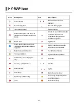
HY-MAP Icon
Icon
Description
Icon
Description
Anchor berths
Beacon with color and
topmark
No Anchoring Area
Position of fog signal
Pilot boarding place
Radar reflector
Wreck showing any part of hull or
superstructure at the level of Chart
Datum.
Wreck, in over 200m or depth
unknown, which is not
considered dangerous to
surface navigation
Marine farm
Lighthouse
Wreck, depth unknown, which is
considered dangerous to surface
navigation
Military restricted area into
which entry is prohibited
Radar transponder beacons
Yacht harbor, Marina
Fishing prohibited
Lighted offshore platform
Conical buoy, nun buoy, ogival
buoy
Oil tanks
Can buoy, cylindrical buoy
Wrecks
Spherical buoy
Lights
Pillar buoy
Barrel buoy, tun buoy
Spar buoy, spindle buoy
Superbuoy. Superbuoys are
very large buoys
Tides
Port information(
Summary of Contents for Smart10 Series
Page 8: ... 8 ...
Page 11: ... 11 2 Specification of the connectors 2 1 Metal connectors ...
Page 12: ... 12 2 2 Plastic connectors ...
Page 15: ... 15 3 3 Navigation Data Page 3 3 1 Navigation Data Type1 3 3 2 Navigation Data Type2 ...
Page 19: ... 19 ...
Page 25: ... 25 Fig 1 3 3 When finishing press to exit ...
Page 28: ... 28 Fig 1 6 3 ...
Page 39: ... 39 2 2 Detail Choose the AIS target and press ENTER 2 3 Goto Choose the AIS target and press ...
Page 45: ... 45 ...
Page 51: ... 51 2 9 Sorting MENU Userdata WPT List MENU Sorting the order of WPT on the list ...
Page 63: ... 63 The maximum range of Correction Offset is 5nm ...
Page 71: ... 71 ...
Page 79: ... 79 ...
Page 95: ... 95 ...
Page 98: ... 98 Smart10 Flush Mounting Smart7 8 Flush Mounting ...
Page 111: ... 111 ...


