background image

iQue 3600a Que Applications Guide 

37

Caution Elevation

Select the desired 

Caution Elevation

. If the terrain 

or an obstacle is within the 

Caution Elevation

 you 

entered, the iQue 3600a displays an alert. 

Look Ahead Time

The 

Look Ahead Time

 for Terrain and Obstacle 

Alerts determines the time when an alert annunciation 

(a pop-up window) occurs. For example, if 120 

seconds is selected, the iQue 3600a displays an alert 

120 seconds before you reach the terrain or obstacle. 

Alert Sensitivity

The three Alert Sensitivity settings (

Terrain

Obstacle

, and 

Descent Rate

) determine what level 

of alerts are annunciated. The iQue 3600a defaults to 

High

 sensitivity, which annunciates all red and yellow 

alerts at the time set in 

Look Ahead Time

Medium


sensitivity annunciates all of the red and the highest 

priority of yellow alerts, and 

Low

 sensitivity only 

annunciates red alerts. 


NOTE: 

A red X appears on the Terrain page if 

the unit has not gathered elevation information.

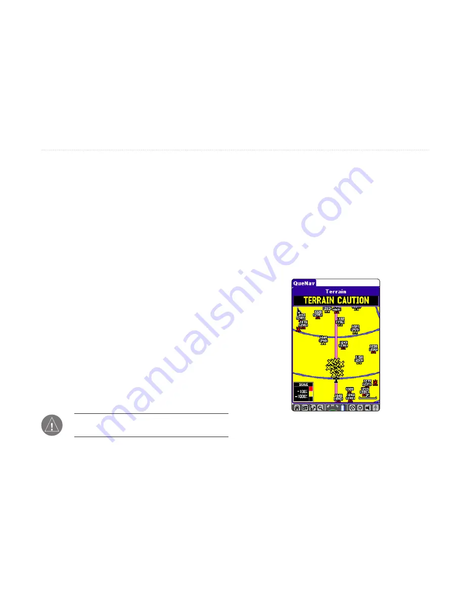
Viewing the Alert Pop-up Windows

While in any application in the iQue 3600a, pop-up 

alert windows appear to inform you of an extreme 

descent rate, an obstacle warning, or a terrain 

warning. The alert windows appear over the current 

application, as shown in the image below. To close the 

pop-up alert and return to the application you were 

using, tap the screen. You can also press 

ESCAPE

 to 

close the alert. 

Obstacle Caution Alert displayed while QueNav is open.

A

DVANCED

 A

VIATION

 O

PERATION

 > 

S

ETTING


UP

 Q

UE

T

ERRAIN

Summary of Contents for iQue 3600a

Page 1: ...iQue 3600a integrated handheld Que applications guide...

Page 2: ...py of this manual must contain the complete text of this copyright notice and provided further that any unauthorized commercial distribution of this manual or any revision hereto is strictly prohibite...

Page 3: ...with your iQue handheld This Que Applications Guide This Que Applications Guide describes how to navigate with the Que Applications To get the most out of your new navigation system take time to read...

Page 4: ...ve Mode section provides you with information about basic features such as creating a route and marking a waypoint More advanced navigation features such as editing waypoints and routes are discussed...

Page 5: ...rving Battery Power 6 Using the Flip Cover 7 Using Your iQue 3600a 8 Common iQue 3600a Handheld Terms 8 Selecting Options and Entering Data 9 Que Applications 10 Changing the Mode 11 Using the Databas...

Page 6: ...Caution Elevation 37 Look Ahead Time 37 Alert Sensitivity 37 Viewing the Alert Pop up Windows 37 QueE6B 38 QueWeight Balance 40 Entering the Aircraft Pro le 40 Calculating Weight and Balance 42 Basic...

Page 7: ...QueGPS 65 Satellite Status 65 Establishing a New Location 66 Entering a New Elevation 66 QueTracks 67 Viewing Saved Track Details 68 Setting QueTracks Preferences 68 QueHunt Fish 69 QueSun Moon 70 Que...

Page 8: ...Optional Accessories 86 Care Information 87 Cleaning the Unit 87 Storing the iQue 3600a 87 Learning about GPS 88 Common GPS Terms 88 What is Differential GPS DGPS 88 What is WAAS 89 Map Datums and Loc...

Page 9: ...signals NOTE The antenna is designed to best receive satellite signals when it is aligned parallel with the horizon If the antenna is positioned vertically the iQue s ability to receive satellites may...

Page 10: ...ite signals are being received to establish a 2D x GPS is Off the antenna is closed GPS Tips While the receiver is gathering information your location on the map may display as different from where yo...

Page 11: ...d the nearest aviation points MENU opens the menu along the top of the screen Press again to close that menu ESC ESCAPE exits options menus applications or pages screens When you are panning the map p...

Page 12: ...t in the Aviation Cradle 1 Open the antenna and be sure the ip cover is removed from the iQue 3600a 2 Insert the bottom of the iQue 3600a into the Aviation Cradle 3 Tilt the unit toward the back of th...

Page 13: ...Escape exits menus or pages Application buttons opens the programmed applications Scroll buttons scrolls through choices Zooms in and out of the map QueMap and QueTerrain Increases and decreases your...

Page 14: ...ation QueFind opens QueFind GPS Status displays the status of the GPS signal and battery Tap to open the QueGPS application QueClock opens QueClock Brightness opens the brightness adjustment slider fo...

Page 15: ...on the bottom of the iQue 3600a Bottom of the iQue 3600a Slots for the ip cover 3 Release the wire hinges The cover is now installed When installed properly the Garmin logo is visible when the cover i...

Page 16: ...simply tap the eld with the stylus Highlight when a eld is selected on the screen it is highlighted The position of the highlight is controlled by the Rocker key or where you tap with the stylus On Sc...

Page 17: ...option Press the Thumb Wheel In to select that option To exit a menu or return to the previous setting Press the ESCAPE key When pressed repeatedly the ESCAPE key scrolls through the Applications Laun...

Page 18: ...n to provide a robust user interface for your mapping and navigation features QueVoice and QueAudio are additional Que applications that allow you to record and listen to sound les To quickly access t...

Page 19: ...in the Aviation cradle There is no need to switch back and forth manually To change modes manually in QueMap 1 With QueMap open press the MENU key 2 Use the Rocker key to highlight Switch Usage Mode P...

Page 20: ...wner s Manual and online Help File Database Updates The internal Jeppesen database provides position and facility information for thousands of airports VORs NDBs and more Updates to the Jeppesen datab...

Page 21: ...eNav and Active Route An example of each application in the Aviation Mode sequence appears to the right To scroll through the main aviation applications press the Que button on the front of the iQue 3...

Page 22: ...Identi er Facility or City and press ENTER Choose a search method from the pick list 3 Highlight the Name eld and press ENTER 4 Highlight the rst letter of the name and then press the Rocker key Up o...

Page 23: ...the desired destination from the list 4 Press ENTER to open the Details page for that item The Details page provides information on the Airport Comm communications Runway and Approach 5 Highlight the...

Page 24: ...formation page for the destination airport as described on the previous page 2 Highlight Comm and press ENTER Frequency with Usage Restrictions Comm tab selected to view communication frequencies for...

Page 25: ...d the NEAREST key to view the Nearest Airport list again The Aviation Nearest page is part of the QueFind application You can also search the rest of QueFind by pressing the NEAREST key To nd the near...

Page 26: ...nd ATIS VOR VHF Omnidirectional Radio Beacons nearest 15 with identi er facility type symbol bearing distance and frequency NDB Non Directional Beacons nearest 15 with identi er facility type symbol b...

Page 27: ...re denoted by a TX and RX respectively To view additional communication frequencies 1 Press the NEAREST key to open the Aviation Nearest page of QueFind Keep pressing it until the ARTCC or FSS categor...

Page 28: ...he Select Approach option allows you to quickly retrieve and select available approaches This option overrides your current route The original route is still available for later use To select an appro...

Page 29: ...ENTER 5 Highlight the Name eld and press ENTER Use the Rocker key to begin entering the name or part of the name When the desired location appears in the results list press ENTER use the Rocker key to...

Page 30: ...While in QueMap you can tap the Flag icon 2 To accept the waypoint with the default name Waypoint use the Rocker key to highlight OK and press ENTER TIP You can use the stylus and the Graf ti 2 area...

Page 31: ...re added to the route The route is automatically saved to the unit s memory The iQue 3600a begins navigating the route To stop navigation press MENU highlight Deactivate and press ENTER To navigate a...

Page 32: ...heading straight up you are heading directly to your destination There are two map orientation options North Up orients the map like a paper map while Track Up orients the map in the direction of tra...

Page 33: ...serving the VNAV indicator teal horizontal bars on the HSI when visible Watch for Terrain Changes and Obstacles Press the Que button until QueTerrain is displayed QueTerrain provides an overhead view...

Page 34: ...d Level AGL Refer to the Obstacle Icons legend to the right Each obstacle is labeled with the altitude of the top of the obstacle or Mean Sea Level MSL Each obstacle also lists the actual height of th...

Page 35: ...were using tap the screen You can also press ESCAPE to close the alert Track Your Progress with Active Route Press the Que button until the Active Route page is displayed This page shows each point of...

Page 36: ...has three levels of declutter The rst level shown is identi ed by Clear 1 over the map scale The background map detail including highways cities rivers smaller lakes is removed from the map display 4...

Page 37: ...en QueNav and follow the steps listed above To measure the distance between two points 1 From QueMap tap the Menu icon to open the options menu 2 Tap Que to display the Que options menu 3 Tap Measure...

Page 38: ...ing a route press the Que button to open QueNav 2 Press MENU 3 Highlight Set OBS Hold and press ENTER An OBS data eld appears on the display 4 Press the Rocker key and press ENTER Use the Rocker key t...

Page 39: ...g editing methods from the list Insert Waypoint allows you to add an Aviation Point using QueFind Inserts the new point before the selected point Remove Waypoint deletes the selected point from the ro...

Page 40: ...Repeat steps 2 through 5 until all points are added to the route Tap Done To edit the route on the map with the Aviation Cradle 1 Press the Que button to open the Active Route page 2 Press MENU Use t...

Page 41: ...direction to the inbound course On the Active Route or Active Approach page a Vector to Final symbol appears adjacent to the rst approach waypoint If you select No on the Vectors window the iQue 3600a...

Page 42: ...your progress As you approach the initial descent point the time to vertical navigation eld ETV indicates the time to reach the initial descent point The descent angle locks to prevent changes in spe...

Page 43: ...the target location by the distance Before or After the VNAV Waypoint normally the nal destination airport To set the target location at the VNAV Waypoint enter a distance of zero VNAV Waypoint allows...

Page 44: ...ata elds and page 92 for information about the data eld types To set up QueTerrain 1 With QueTerrain open tap the menu bar or menu icon Tap Preferences You can also select Prefs from the Applications...

Page 45: ...igh sensitivity which annunciates all red and yellow alerts at the time set in Look Ahead Time Medium sensitivity annunciates all of the red and the highest priority of yellow alerts and Low sensitivi...

Page 46: ...quired entry for winds aloft calculation Use the heading from the aircraft s heading indicator or directional gyro True Airspeed calculated or user entered gure required entry for winds aloft calculat...

Page 47: ...ed Airspeed Baro Pressure and Total Air Temperature The calculated gures for True Airspeed and Density Altitude are displayed To calculate winds aloft 1 Follow the previous steps to determine true air...

Page 48: ...00a To open QueWeight Balance display the Que Applications Launcher by pressing ESCAPE Highlight QueWeight Balance and press ENTER Entering the Aircraft Pro le Before you perform Weight and Balance op...

Page 49: ...um speeds for your aircraft and the aircraft s fuel ow Tap Done 7 Tap Done to exit the Aircraft Pro le Preferences To select a saved aircraft pro le 1 From Aircraft Pro le Preferences tap the Current...

Page 50: ...each item in the aircraft including the aircraft Also enter the location of each item so that the center of gravity can be calculated To enter weight information 1 Tap the Home icon to open the Que A...

Page 51: ...to indicate the placement within the aircraft To calculate Weight and Balance Enter all weight and arm gures as described in the previous two procedures The calculated moment weight and CG gures appe...

Page 52: ...auncher tap Prefs 2 Tap the pick list in the top corner and select Usage Mode from the list 3 Tap the Navigation Mode pick list and select Automotive from the list The iQue 3600a is now in Automotive...

Page 53: ...Route to The iQue 3600a automatically generates a turn by turn route for you to follow to the location You can also route to a point on the map using the options menu After tapping the desired locati...

Page 54: ...hen use that point as a destination You can also view details about items such as addresses and telephone numbers Palm OS Find is a Palm OS application for nding items within the Palm OS Operating Sys...

Page 55: ...ate a turn by turn route and begin navigating to the location tap Route to Using the Find From Feature The nd from feature of QueFind allows you to search for items near a different location such as y...

Page 56: ...a dotted box then tap an item in the list To search all cities regions or postal codes tap Use All at the bottom of the dialog box 3 Using the Graf ti 2 area enter the desired street number in the Nu...

Page 57: ...the Pre x Suf x button to select the remainder of the street name if applicable 4 Repeat step 3 for Street2 5 Tap Search Tap the desired entry from the displayed list Finding Points of Interest If you...

Page 58: ...low you to search for letter combinations contained in the name of the item Be sure By Name is not selected as the search method and Containing is displayed instead of Name To quickly change QueFind c...

Page 59: ...o mark your location as a waypoint 1 Tap the position icon to re center the map on your current position 2 Tap the Waypoint ag icon at the bottom of the map The New Waypoint dialog box is displayed wi...

Page 60: ...ialog box The name displayed depends on the item selected Or tap the Route To button at the bottom of the QueFind screen To select a destination using QueMap 1 Press the Que button to display QueMap 2...

Page 61: ...and direction of travel As you move the triangle moves with you turning when you turn and stopping when you stop As you travel to the edge of the display the map moves redraws to constantly show your...

Page 62: ...ou are in Pan Mode Place the stylus on the map and drag it The map moves with the stylus and shows the part of the map previously out of view Lift the stylus to stop panning When the panning arrow is...

Page 63: ...ueTurns is displayed Each turn you will take in the route is displayed Each turn entry provides a direction arrow showing the direction to turn and the distance to that turn as well as written instruc...

Page 64: ...t your trip be sure to reset QueTrip before you start traveling While in Automotive Mode press the Que button repeatedly to display QueTrip QueTrip To reset QueTrip 1 Press the Que button several time...

Page 65: ...until the All Applications Launcher is displayed Tap the Address Book icon Or simply press the Address Book button on the front of the unit 2 Your Address Book opens Tap the desired waypoint from the...

Page 66: ...between pages of symbols 6 Tap OK to use the selected symbol Tap Done to complete the change To change the location of a waypoint 1 From the Address Book tap the waypoint you want to move 2 Tap the L...

Page 67: ...diting Stops Via Points You can add via points points through which you would like to travel to your route using Edit Vias To add via points to your route 1 While navigating your route tap the QueRout...

Page 68: ...detour Saving a Route Once you have created a route to a destination and while it is still active you can save the route to use at a later time To save a route 1 While navigating a route tap the QueRo...

Page 69: ...low this route on roads If you tap Yes the iQue 3600a automatically generates a turn by turn route to the destination Stopping and Resuming Navigation You can stop navigating a route at any time To st...

Page 70: ...options 4 Select one of three methods to set the location Tap the Find button to use QueFind to nd a location Tap the Manual button to enter new location coordinates Tap the Map button to display the...

Page 71: ...can also generate a route through the Address or Date Book To navigate to an Address Book entry 1 Open the Address Book Tap the desired Address Book entry 2 Tap the QueRoutes icon Tap the Route To are...

Page 72: ...the ight entry is saved and a new entry will be recorded when you depart the airport A touch and go or brief stop of less than ten minutes will append to the current ight record instead of starting a...

Page 73: ...icular satellite that is being received Numbers above 33 indicate WAAS satellites When the satellite is being fully received the bar above the corresponding number is solid When information is still b...

Page 74: ...o pan the map to your current general location and tap to place the arrow there 4 Tap Done to continue the initialization Entering a New Elevation The GPS receiver can determine your approximate eleva...

Page 75: ...y part of the track log select the start and end points and tap OK 6 To save the whole track tap Entire Log The newly saved track appears in the Saved Tracks list To use QueTracks 1 Tap the Home icon...

Page 76: ...e Color name at the top of the page Tap the desired color from the list to select and close the list If the Show On Map option is checked the saved track is displayed on the map Setting QueTracks Pref...

Page 77: ...g and shing information for your current location and date Que Hunt Fish Tap to select a different date Tap to select a different location The day s Prediction Best Times and Good Times are displayed...

Page 78: ...ion for your current location and date 3 The moon phase as well as locations of the sun and moon are displayed Use the controls to view animation of the sun and moon positions QueSun Moon Tap to selec...

Page 79: ...PC and click the Install icon to display the Install Tool dialog window 3 Drag and drop les from your PC into the Install Tool window or click Add and select the audio les 4 Click Done The les will be...

Page 80: ...hen Shuf e To view details about selected les 1 Highlight the desired le from the list on the QueAudio page 2 Tap the menu bar at the top of the page 3 Tap File and then tap View Details to display th...

Page 81: ...d or tap the Record icon QueVoice is now recording Speak into the microphone hole on the front of the iQue 3600a 4 While recording brie y press the REC button or tap the Pause icon to pause Tap again...

Page 82: ...n from the selected le tap Remove Location and then tap OK Importing and Exporting QueVoice Files You can import and export WAV voice les using the beaming feature or a HotSync operation If a location...

Page 83: ...t Changing the GPS Settings Enable and disable WAAS and Battery Saver Mode through the GPS Preferences You cannot turn on WAAS and Battery Saver modes at the same time To enable WAAS or Battery Saver...

Page 84: ...erences 2 Tap the pick list in the left corner and select Maps from the list 3 To open a different QueMap Preferences page such as the Airport Preferences tap and select a different settings page from...

Page 85: ...Que Preferences 3 Tap Maps and select Location from the list Location Preferences 4 Change the settings as necessary Setting Airspace Alarms You can enable or disable alerts that notify you when you...

Page 86: ...ng an Avoidance area or item sets the iQue 3600a to create a route that does not include the items or area you enter An Avoidance stays in the unit s memory until you remove it or it expires All route...

Page 87: ...Off Route Recalculation Turn Preview Voice Prompt and Attention Tone To set guidance preferences 1 While in Automotive Mode tap the QueRoutes icon 2 Tap Route Preferences 3 Tap Routing and tap Guidan...

Page 88: ...ustment slider for the backlighting and power LED When connected to external power the power LED has two brightness settings Bright and dim Move the slider to the Left to lower the brightness and to t...

Page 89: ...Use the arrows to change the order of the Que Applications The application at the top displays rst Place a check mark in the box to add the application to the Que button sequence To change what appli...

Page 90: ...s each time you tap the icon NOTE You must rst change the layout of QueTerrain before you can change the data elds To change a data eld 1 Open QueMap QueNav or QueTerrain 2 Tap the Menu icon 3 Tap Cha...

Page 91: ...s button 5 To restore only the current page s settings tap OK To restore all Que Preferences to their original settings tap Restore All To restore the data eld settings 1 Open the page QueMap QueNav o...

Page 92: ...on with the backlight set at 50 3 hours of continuous operation with the backlight set at 100 Battery life varies depending upon temperature programs installed and individual use patterns Performance...

Page 93: ...tery life keep the backlight off Set the iQue 3600a to turn off automatically after 30 seconds of inactivity to increase the battery life This adjustment is made in the General Preferences When the iQ...

Page 94: ...s and detailed maps to use the iQue 3600a in an automobile Yoke Mount Kit provides the necessary parts to mount your iQue 3600a on a second yoke Travel Kit includes an A C travel charger Sync cable in...

Page 95: ...s not water resistant and should not be immersed in water Immersion in water voids your warranty To resolve problems that cannot be remedied using this guide contact Garmin Product Support in the U S...

Page 96: ...ed it remembers its location and acquires a position more quickly Position an exact unique location based on geographic coordinates Latitude and Longitude Route a group of waypoints entered into the G...

Page 97: ...der that adheres to the MOPS Minimum Operational Performance Standard for global Satellite Based Augmentation Systems SBAS Eventually there will be several services of worldwide geostationary communic...

Page 98: ...rence on the paper chart you are using Set the Map Datum to match the map datum used by your chart What is a Location Format and which one should I use Your current location can be viewed on the GPS i...

Page 99: ...airport ASOS ATIS and AWOS VORs identi er facility name city state country position frequency service volume and type such as VOR DME TACAN and VORTAC NDBs identi er facility name city state country p...

Page 100: ...cation to a Go To destination or the next waypoint in a route ETA Dest Estimated Time of Arrival at Destination the estimated time you will reach a Go To destination or the nal waypoint in a route ETA...

Page 101: ...r Total total time the unit has been in operation since last reset of the trip timers Track the direction of movement relative to a ground position Also referred to as ground track Trip Odometer the t...

Page 102: ...ave entered a route name that already exists Route Memory Full no additional routes can be saved Route Truncated uploaded route from another device has more than 50 waypoints Route Waypoint Memory Ful...

Page 103: ...ay cause harmful interference to radio communications if not installed and used in accordance with the instructions However there is no guarantee that interference will not occur in a particular insta...

Page 104: ...country in violation of the export control laws of the United States of America Limited Warranty This Garmin product is warranted to be free from defects in materials or workmanship for one year from...

Page 105: ...instructions and an RMA tracking number The unit should be securely packed with the tracking number clearly written on the outside of the package The unit should then be sent freight charges prepaid...

Page 106: ...entral Time or by e mail at sales garmin com In Europe contact Garmin Europe Ltd at 44 0870 8501241 Safety Information WARNING The iQue 3600a contains a lithium ion rechargeable battery The battery us...

Page 107: ...RODUCT IS INTENDED TO BE USED ONLY AS A NAVIGATIONALAID AND MUST NOT BE USED FOR ANY PURPOSE REQUIRING PRECISE MEASUREMENT OF DIRECTION DISTANCE LOCATION OR TOPOGRAPHY THIS PRODUCT SHOULD NOT BE USED...

Page 108: ...e driver or passengers causing possible injury Refer to airbag safety precautions contained in the vehicle owner s manual Do not mount the unit in a place where the driver or passengers are likely to...

Page 109: ...85 Battery Saver 75 Brightness 5 6 85 Buttons 5 customize 81 C Calculate Density 39 Calculating Weight and Bal ance 42 Caution Elevation 37 CDI 30 scale 29 Center of Gravity CG 40 Change Data Fields...

Page 110: ...3 Frequency Restrictions 16 FSS 18 91 Fuel Flow 40 G Get Signals 1 Going to an Address Date Book Entry 63 Go To 14 Go to an Airport 14 Go To Location 45 Go To Nearest 17 GPS 2 65 66 icon 6 learning ab...

Page 111: ...ch 20 Put iQue in Aviation Cradle 4 Q QueAudio See Audio QueClock See Clock QueE6B See E6B QueFind See Find QueGPS See GPS QueHunt Fish See Hunt Fish QueMap See Map QueNav See Nav QueRoutes See Routes...

Page 112: ...b Wheel 5 Toolbar See Icons Tracks 67 preferences 68 Track Log 67 Track Up 24 53 76 Trip 56 Trip Data 56 Turns 55 Turn Off Off Route Recalcu lating Announcement 79 Turn Preview 55 79 U U Turns 78 Upco...

Page 113: ......

Page 114: ...rmin Web site at www garmin com Copyright 2004 Garmin Ltd or its subsidiaries Garmin International Inc 1200 East 151st Street Olathe Kansas 66062 U S A Garmin Europe Ltd Unit 5 The Quadrangle Abbey Pa...

Reviews: