Index
A
AIS
4–6
alarm
5
distress signal device
5
radar
19
SART
5
targeting
4, 5
threats
4, 19
turning on
24
vessels
19
alarms
23
anchor drag
23
arrival
23
collision
5
deep water
16
navigation
23
off course
23
shallow water
16
sonar
16
water temperature
16
anchor drag alarm
23
animated currents, tides
4
arrival alarm
23
Auto Guidance
8, 23
line
23
shoreline distance
24
B
backlight
2
C
celestial information
12
charts
2, 4, 6
appearance
7
details
3
heading, line
7
navigation
3, 4
panning
2
symbols
2
clock
23
alarm
23
collision alarm
5
color mode
2
combinations
11
customizing
11
selecting
11
compass
11
rose
6
compass tape data bar
6
courses
8
current stations
12
indicators
4
D
data
backup
25
copying
25
data fields
6
data management
24
deleting, all user data
11
depth log
16
destinations
navigation chart
7
selecting
7, 8
device
cleaning
25
keys
1, 2
registration
25
digital selective calling
16, 17
channels
17
contacts
16
individual routine call
17
turning on
16, 24
distress call
16, 17
distress signal device
5
DSC.
See
digital selective calling
E
EBL
19
adjusting
19
measuring
19
showing
19
EGNOS
21
environment gauges
12
environmental gauges
12
EPIRB
5
event log
22
F
factory settings
24, 25
sonar
16
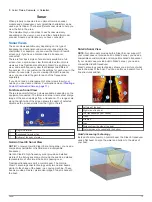
Fish Eye 3D
sonar cone
7
suspended targets
7
tracks
7
fishing chart
2
boundary line
5, 10, 11
panning
2
setup
6
G
Garmin ClearVü
13
Garmin Marine Network
22
Garmin product support, contact information
1
gauges
environment
12
environmental data
12
trip
11, 12
wind
12
GLONASS
21
Go To
8
GPS
EGNOS
21
GLONASS
21
signals
2
WAAS
21
GPS accuracy
23
H
hazard colors
7
help.
See
product support
home screen, customizing
2
K
keel offset
22
keys
1
power
1
shortcut
1
L
lane width
7
language
21
M
man overboard
8
marine services
8
mark location
8
MARPA
5
tagged object
19
targeting
18, 19
memory card
25
installing
1
MOB, device
5
N
navaids
3
navigation alarms
23
navigation chart
2, 4, 7
aerial photos
6
boundary line
11
marine service points
8
panning
2
radar overlay
20
setup
6
vessel trails
6, 17
navigation inset
6
NMEA 0183
16, 22, 23, 26
O
off course alarm
23
offset, front of boat
21
other vessels
AIS
6
trails
6
overlay numbers
6
P
position, tracking
17
position report
17
power key
21
powerboat
2
premium charts
3, 4
Fish Eye 3D
7
tide and current indicators
4
product registration
25
product support
1
R
radar
17, 18, 20
AIS
19
clutter
21
color scheme
21
field of view
21
front-of-boat offset
21
gain
20
optimizing display
20
overlay screen
20
range
20
range rings
21
sentry mode
18
timed transmit
18
tracks, Fish Eye 3D
5
transmitting
18
waypoints
5, 18, 21
zoom scale
18
radar overlay
20
range rings
7
registering the device
25
routes
copying
24, 25
creating
9
deleting
10
editing
9
navigating
9
navigating parallel to
10
radar
10
viewing list of
9
waypoints
25
S
safe depth
23
safe height
23
safe zone collision alarm
5
sailboat
2
SART
5
satellite imagery
4
satellite signals, acquiring
2
screen, brightness
2
screenshots
25
capturing
25
sentry mode
18
guard zone
18
timed transmit
18
settings
21–23
radar display
21
system information
22, 24, 25
shoreline distance
24
SideVü
13
software, updating
1
software license agreement
26
sonar
13
a-scope
15
alarms
16
appearance
15
bottom lock
14
color gain
14
color rejection
15
cone
7
Index
27