EchoMap v3.0
26
4.1.4
Airport Metar Weather Page
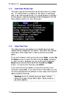
The Metar page will show whether the selected airport is a Metar
site. If a textual Metar is available for this airport, it will display
both in raw and decoded format. If a graphical Metar is available
for this airport, a textual interpretation will be displayed. See the
Metar Weather section for more information.
4.1.5
Airport Plates Page
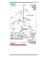
The plates page lists and displays any installed approach plate
images that are available for the airport. Only users with a plates
subscription (Echo Flight Plan3 or Plan4) will have these NOS
plates.
If you aren’t already in full screen mode, press
Enter
. Use the
Up
and
Down
arrows to select the chart and press
Enter
to display
it. When a chart is displayed, you can scroll it with the
Up
and
Down
arrows and zoom and scroll with the
Left
and
Right
arrows. To return to the chart list, press
Enter
.
If you have a printer connected, you can print a plate you are
viewing by pressing
F6
. If you need to print more plates, you can
use the provided EchoChart software to more easily view and print
plates outside of Echomap.
Warning:
Never try reading electronic plates in flight!
Always print paper copies before flight. Please check for
any chart updates.
Summary of Contents for EchoMap 3.0
Page 27: ...EchoMap v3 0 27...

