Map Page
Entegra EX5000
-20-
600-00121-001 Rev 01
2.3 Map Symbols—Runways and Flight Plan
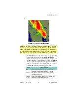
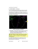
Figure 2.4 Map page Symbols—Runways and Flight Plan
1) Airport Runway Diagrams
—Displays runway layouts of nearby
airports. As you range in, the scaled runway diagram with
heading labels shows your exact location in proximity to the field.
2) Flight Plan
—Displays the active flight plan from the GPS. The
current leg displays in magenta and all remaining legs are shown
in white. When you select an approach procedure on the Garmin
430, all approach segments including holds, DME arcs, and
procedure turns, are shown (when connected via the ARINC 429
bus).
Note
: For most GPS units, the EX5000 cannot display the active course leg
when you are adjusting the desired track in OBS mode. The desired track
leg will be displayed after you finish selecting the course and exit the OBS
mode of the GPS.
6
4
5
2
3
1
Summary of Contents for Entegra EX5000
Page 1: ...600 00121 001 Rev 01 Entegra EX5000 ...
Page 2: ...Entegra EX5000 600 00121 001 Rev 01 ...
Page 8: ...Entegra EX5000 vi 600 00121 001 Rev 01 This page intentionally left blank ...
Page 20: ...Introduction Entegra EX5000 6 600 00121 001 Rev 01 THIS PAGE INTENTIONALLY LEFT BLANK ...
Page 38: ...Map Page Entegra EX5000 24 600 00121 001 Rev 01 ...
Page 66: ...CMax Chart Pages Optional Entegra EX5000 52 600 00121 001 Rev 01 ...
Page 91: ...600 00121 001 Rev 01 77 Entegra EX5000 THIS PAGE INTENTIONALLY LEFT BLANK ...
Page 92: ...Trip Page Entegra EX5000 78 600 00121 001 Rev 01 ...
Page 96: ...Entegra EX5000 82 600 00121 001 Rev 01 THIS PAGE INTENTIONALLY LEFT BLANK ...
Page 188: ...Reference Entegra EX5000 174 600 00121 001 Rev 01 ...
Page 198: ...Entegra EX5000 184 600 00121 001 Rev 01 This page intentionally left blank ...
Page 199: ......


