background image


9.4 Process Dataset 

9.4.1 Standard Data Processing Workflow 


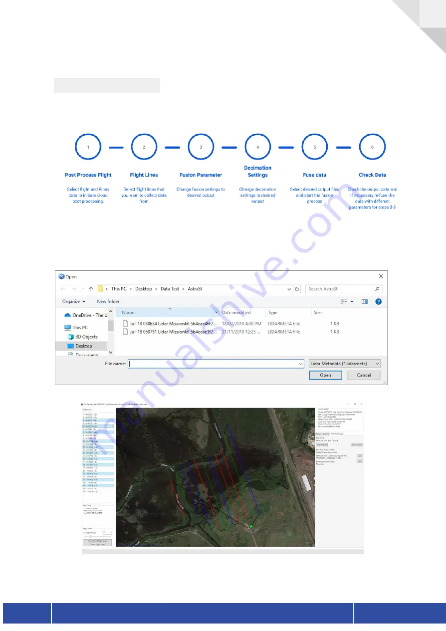
When choosing to process a single dataset you will be prompted to select the data that you


wish to process. Navigate to the directory within which your dataset is located and select the


appropriate lidarmeta file corresponding to the UTC time of the mission.   


Version 1.1 

NextCore RN50 User Guide


26 


Summary of Contents for NextCore RN50

Page 1: ......

Page 2: ...Installation 8 5 2 3 2 API Settings Configuration 9 6 NextCore Installation 10 6 1 Standard Installation Workflow 10 6 2 Attaching the M600 mount kit 11 6 3 Antenna Installation 12 6 4 Mechanical Drawings 13 6 5 RN50 Pinout 13 6 6 Mounting the payload to an M600 14 7 Mission Planning 15 7 1 Manual vs Grid Flights 15 7 2 Key Considerations 15 7 3 Suggested operating parameters 17 7 4 Flight Plannin...

Page 3: ...d Data Processing Workflow 25 9 5 2 Post Processing 26 9 5 3 Flight Line Selection 28 9 5 4 Fusion Settings 30 9 5 4 1 Fusion 32 9 5 4 2 Combined Decimation 32 9 5 5 Export Settings 33 9 5 5 1 Export Paths 33 9 5 5 2 Export Options 33 9 5 5 3 Export Projections 34 9 5 5 4 Export Outputs 34 10 Additional Attachments 35 10 1 RGB Camera 35 11 Troubleshooting 36 11 1 Hardware OLED Errors 36 11 1 1 Lin...

Page 4: ...ion Version Change Log Description 1 1 Initial User Guide release 1 2 Software Version Change Log Description 3 1 7124 2188 Initial Nextcore release 1 3 Hardware Hardware Version Firmware Change Log Description 1 0 1 3 1 603 Initial RN50 release Version 1 1 NextCore RN50 User Guide 3 ...

Page 5: ... m600 You must operate in accordance with DJI m600 User Guide at all times In order to ensure your unit performs to its specifications and remains operable it is important that you read through this User Guide carefully If you are in doubt regarding the contents of this user guide it is important that you contact your distributor for clarification or further training Thank you for your purchase th...

Page 6: ...ing guidelines of this unit and the guidelines of the equipment it is attached to at all times 4 List of Items 4 1 Nextcore RN50 1x Payload 1x Power Adapter 1x 64GB USB Thumb Drive 4 2 M600 Mounting Kit 1x M600 Mounting Kit 1x Power and API Adapter 2x Antenna Booms 4x Vibration Isolators 4 3 Custom Pelican Hard Case 1x 1615 Air Pelican Hard Case 1x RN50 Tool Kit Version 1 1 NextCore RN50 User Guid...

Page 7: ...on other UAV s please make sure to follow the recommended user guide of both the desired UAV and the Nextcore product The following is an explanation on how to configure the M600 to carry the Nextcore product and how to configure the DJI API port to enable the auto capture feature This section assumes that you have the Nextcore RN50 M600 mounting kit Please refer to the DJI M600 user guide and rec...

Page 8: ...n be left on your M600 5 2 2 Power Installation The NextCore RN50 system is designed to take power from the UAV This reduces payload weight and increases flight time compared to an integrated battery system As such an inline connector is provided with the system The RN50 takes a 6S LIPO input 20 26 2v On the M600 this can be tapped into via the XT30 connector between the M600 battery pack and the ...

Page 9: ...his connection will enable the auto start capture feature of the RN50 unit This will start the capture of the system on flight arm and disarm take off and land This cable and associated A3 setting can be left attached to the system and will not impede with regular flight operations 5 2 3 1 Cable Installation Version 1 1 NextCore RN50 User Guide 8 ...

Page 10: ...versible damage to the RN50 unit The other end of this can be fed through the M600 frame to be exposed at the bottom ports of the system This Futaba servo connector can then be used in conjunction with the provided RN50 Molex connector 5 2 3 2 API Settings Configuration The API settings on the A3 will also need to be enabled to allow for API control of the payload Using DJI assistant 2 enable the ...

Page 11: ...00 unit Please make sure that the vibration isolation mounts are attached to the M600 before continuing with this step The API cable should already be installed if you want to use the auto capture feature Your RN50 system should arrive with the M600 mounting system already assembled on the payload If this is not the case or you have bought the mounting solution after the initial unit please follow...

Page 12: ...s This will increase the accuracy of the IMU as it depends on the fixed position of the primary antenna as seen in B It is also important to centre the 12mm clamps over the front wing of the RN50 as seen in A The centre of mass is towards the Lidar so mounting the tube clamps over the centre of mass will improve flight efficiency and stability of the UAV The easiest way to assemble this mounting k...

Page 13: ...nna to the payload two SMA breakouts on the top of the unit It is important to connect the forward antenna Lidar side to the primary connector and the back antenna to the secondary antenna Antennas are colour coded in order to avoid confusion To follow the DJI standard of orientation colouring the primary antenna is red whilst the secondary antenna is green The antennas may be removed while the pa...

Page 14: ...ugh four M3 mounting holes located on the top of the product Screws must penetrate the RN50 with at least 15mm of thread from the top of the plastic 6 5 RN50 Pinout Pin Function 1 VCC 2 GND 3 NC 4 API UART RXD 5 API UART TXD 6 Signal GND Version 1 1 NextCore RN50 User Guide 13 ...

Page 15: ...00 To attach the unit to the M600 using the 12mm rails provided in the mounting kit This will fit into the vibration isolators circular opening The best practice is to undo all clamps insert one side of the payload into the vibration isolators and then slide forward them back into the opposite side Once the payload is within the vibration isolators centre the payload so that the small indicator li...

Page 16: ...n 7 mins this allows time for filters to settle and produce better data Each flight should include a few slow manoeuvres with pitch and roll in each direction consistently for a few seconds This may be a simple box pattern once up to flight altitudes This helps the filters settle and learn the pitch roll offsets Smooth flight lines are required for a good dataset preferably automated with a consis...

Page 17: ...tude to get LiDAR returns Yawing should be avoided for the most part mission grids should be flown with a consistent heading no yaw at end of lines If for coverage reasons two aspects are required do a grid with one heading and then another grid at 90 degrees with one yaw change between the two If including yaw during a manual flight smooth consistent changes are preferred Optimal flight operation...

Page 18: ...nd which will cause more motion from the UAV Rain should be avoided as exposure to moisture may reduce the lifespan of the unit and void the warranty Available Light is not a concern The RN50 can effectively be used at night and any time of day regardless of light availability Consideration should be given to capturing data when the sun is low sunrise and sunset as direct sunlight into the sensor ...

Page 19: ...d deliverables needed It is best to practice with the RN50 on smaller datasets under different mission setting to understand what settings are appropriate for the desired mission 7 4 1 Grid mission setup Start a new 3d mapping grid mission on the DJI GS pro app Set the desired mission fence and area The camera mode is recommended as A7 or an equivalent camera Make sure to change the capture mode t...

Page 20: ... overlap is chosen to a percentage in order to make sure that the distance between flight lines are within the recommended spacing For this mission the desired flight line spacing was 40m Always change the course angle to give the longest possible flight lines This will reduce mission time and increase IMU filter accuracies Version 1 1 NextCore RN50 User Guide 19 ...

Page 21: ...n there are no internal errors within the system When the two status leds on the display panel are green the system is ready to capture If for some reason the lights are presenting either as a constant red or yellow please refer to the Status Description section below for more details Once these lights are green the system is ready to capture To initiate a capture the user needs to press the push ...

Page 22: ... connected and the A3 must be set to the correct output refer to the API Configuration section This feature will start a capture upon arming of the A3 As such it is important to wait until the RN50 is presenting green lights before arming the A3 When the system is armed the data capture will automatically occur This will show a flashing green light as well as green side leds After the mission is f...

Page 23: ...e whether the system is outputting data correctly If these leds are red it shows an error in the system that will cause data collection issues and must be rectified Green Red Yellow Green Flash Yellow Flash Blue Breath Blue Solid 1 Lidar System Ready System Not Ready Warning in System Capturing data correctly Busy Copying to USB 2 GNSS GNSS Fix No GNSS Fix Acceleration over Range 3 Capture Capturi...

Page 24: ...stem State 2 Lidar Sensor 3 IMU GNSS sensor 4 On board Storage Flight telemetry Information about various display strings can be found in the troubleshooting section of this manual Version 1 1 NextCore RN50 User Guide 23 ...

Page 25: ...uired If this is the case the lidar cali file will need to be placed within the directory of the desired processing data This will overwrite the default calibration and use the new calibration file for this dataset only 9 1 3 Data Management All datasets that are captured by the system are sorted under UTC time within a UTC based date This is done to prevent confusion when capturing areas within d...

Page 26: ...et function this is used within the RN50 model to process a single flight A Payload USB Control allows control of the internal payload storage via the USB Thumb Drive 9 2 Live Telemetry Data Download This function is used for Nextcore generation 1 products only To use this feature please refer to the documentation provided with your Nextcore generation 1 product 9 3 Batch Process Coming soon Versi...

Page 27: ...process a single dataset you will be prompted to select the data that you wish to process Navigate to the directory within which your dataset is located and select the appropriate lidarmeta file corresponding to the UTC time of the mission Version 1 1 NextCore RN50 User Guide 26 ...

Page 28: ...his step within the Nextcore software performs a PPK solution on the trajectory of the payload against a stationary base observer This is achieved through cloud processing and will require an internet connection cable of uploading and downloading up to 300MB of data This process uploads only the flight path IMU and selected base data to be processed to create an accurate lidar trajectory Post proc...

Page 29: ...post process click the Post Process button this will initiate the cloud upload and processing this will be presented in the status bar at the bottom of the software Once the dataset is post processed the base location will be displayed on the Map through a green indicator The dataset details will also change to outline that the dataset has been post processed If after the Post Processing step the ...

Page 30: ...The coordinates provided for Base Location Override should be in the same coordinate system as specified for output in 9 5 5 3 Version 1 1 NextCore RN50 User Guide 29 ...

Page 31: ...ving on processing time Each flight line is split into different colours and flight line ID s This flight line ID is also stored in the point source id once the laz file has been exported The automatic detection of flight lines is controlled by the line split function Depending on the flight software may not automatically detect the correct flight lines the user can change the line split angle Thi...

Page 32: ...nd spacing When this guess flight line function is used the user will be prompted with the number of flight lines found the heading and spacing An example of this is seen below It is important to check that the undesired flightlines have been unchecked This will present as a black line on the map overlay All coloured lines will be fused according to the fusion settings chosen by the user 9 4 4 Fus...

Page 33: ...re software by default the settings are as per above This will suit most data captures however it is important to understand the settings and their implication for the exports These settings are split into the raw fusion settings as well as the optional decimation step Version 1 1 NextCore RN50 User Guide 32 ...

Page 34: ...tting a returns off surfaces that are not very oblique A side effect of this setting is that power lines and small features are sometimes missed Set to zero to disable 9 4 4 2 Combined Decimation Decimation of data is an additional step and will occur after the data is fused together These settings refer to the export of a decimated point cloud which takes the best data from the closest flight lin...

Page 35: ...roll errors Once run flight lines with a calculated roll offset will have an asterisk shown next to them Pressing the clear roll offsets button will remove this and it can be recalculated or left as default The system uses a random sampling to calculate roll offsets so results will vary between runs but are normally fairly consistent 9 4 5 Export Settings This tab refers to the outputs desired fro...

Page 36: ...heck system for the files required in the exports folder These are the deliverables of the software Checking Las File s will output a Las or Laz file depending on the export options selected and the fusion setting chosen Checking Map overlays output as per 9 5 5 6 Checking Combined Deci will output a decimated las laz file in accordance to the decimation setting chosen in the fusion tab this takes...

Page 37: ...lidar returns generally ground surface underneath canopy or objects Average Height Averages based on the heights of lidar returns rejects outliers Spread Height The Max Height from the Min Height generally shows canopy height for vegetated areas Point Density The density of LiDAR returns which ramps from blue to red red being 300ppm 2 Version 1 1 NextCore RN50 User Guide 36 ...

Page 38: ...in order to display all data sets present on the system The RN50 has a usable capacity of around 30GB and holds data in a FIFO First In First Out buffer configuration To access the available datasets on the RN50 system enter the USB payload control function of the nextcore software Plug in the appropriate USB that contains the flight list This will appear in the top drop down drive list select thi...

Page 39: ...his can be done with multiple flights from the set There is also an option to dump or clear all data from the RN50 under the Batch Process tab This will affect all data on the payload Note deleting or clearing data is permanent Make sure this is the appropriate course of action Version 1 1 NextCore RN50 User Guide 38 ...

Page 40: ...when next attached to the payload Attach the USB to the payload to execute the changes ensure it is powered on The command file is removed from the USB at the end of each command sequence While the payload is executing the commands it will display yellow flashing lights wait for this to complete before shutting down the payload Version 1 1 NextCore RN50 User Guide 39 ...

Page 41: ...re not recommended by the manufacturer for the following reasons These attachment methods add additional weight to the UAV and may reduce flight time The mission profile will need to be altered to obtain the appropriate overlap for creating the required mosaic for colourisation As the recommended flight height is 40 metres the number of photos required for a consistent overlap especially if trees ...

Page 42: ... powered down If the issue persists for longer than 2 minutes contact your distributor ERR No data yet Lidar has made a connection the lidar sensor has to spin up to the appropriate speed before data can be read this will take 30 seconds ERR PPS Issue Internal mismatch between lidar sensor and GNSS timestamp This may occur on boot especially if the GNSS receiver has not made a fix yet Give this 30...

Page 43: ...s occurs when the onboard IMU is subjected to more the 2g of acceleration This can cause an error in data quality if the system is continually exposed to high accelerations during data capture This will not occur during a flight if the mission planning guide and vibration isolators are used This may however occur on take off or landing of the system due to the increased acceleration of the system ...

Page 44: ...re if this error presents itself the user can either insert a USB or they can choose to leave the data on the payload for later retrieval Not having a USB in the system at the end of a capture will not result in the loss of that capture data instead it will be stored on the payload for later retrieval You can insert USB after landing to initiate copy of the capture to USB BUSY USB Copy This will a...

Page 45: ...r plug one in before the end of the capture and proceed as normal You can stop the capture and keep the payload powered on whilst you find a USB you can then plug in the USB and the system will dump the previous flight to the USB You can also refer to the Payload USB Commands section of this guide to see how to extract data from the payload My base station was not powered on or not working during ...

Page 46: ... improper handling or misuse of the product or damage caused by crashing or hard landing your UAV The unit is intended to be used in a DJI M600 Multirotor UAV any use of the unit outside these specifications without the express permission of the manufacturer will result in the warranty being declared void For all warranty claims please contact your distributor for further advice Version 1 1 NextCo...

Reviews: