background image

Settings.

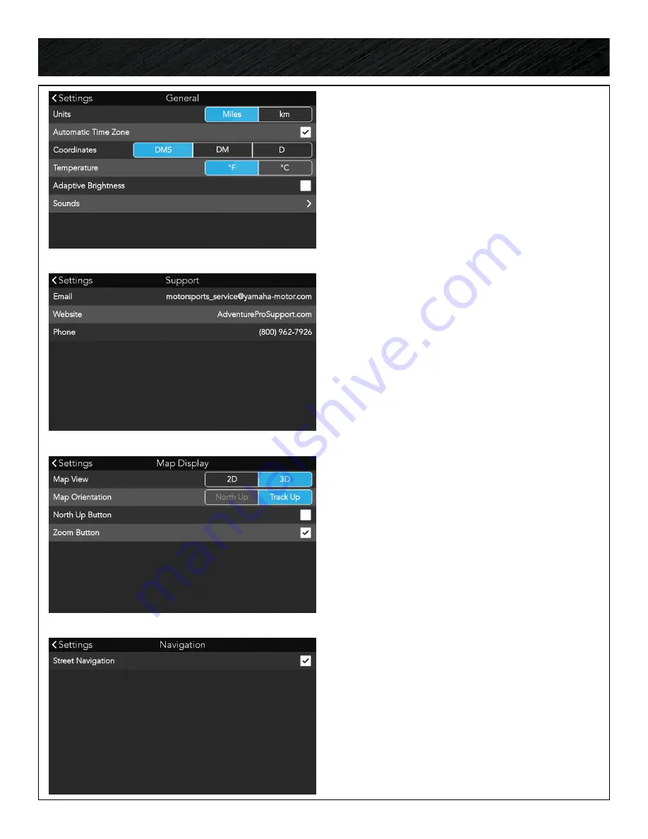
GENERAL

Set preferences for units of measurement, 

coordinate format, temperature, adaptive screen 

brightness and sound settings.

SUPPORT

View contact information to get support for your 

Yamaha Adventure Pro.

Press the support URL to open the support 

pages for Adventure Pro to search and read 

more how to articles and video tutorials.

MAP DISPLAY

Set preferences for 2D/3D, map orientation and 

to turn ON/OFF the north up and zoom buttons 

on the map screen.

NAVIGATION

By default, the ability get turn by turn navigation 

on streets is turned off.  If you choose to use 

your Yamaha Adventure Pro GPS in a street-legal 

vehicle, you can turn ON Street Navigation to get 

turn by turn street directions to your destination.

Press 

Navigation.

Turn ON/OFF street navigation.

41

Содержание ADVENTURE PRO

Страница 1: ...Owner s Manual ...

Страница 2: ...e vehicles When you use this system on other vehicles take extra care whether using the windshield mount or other mount or accessories that it does not obstruct the driver s view of the road interfere with the operation of the vehicle s safety devices such as airbags or present a hazard to occupants of the vehicle should the receiver be dislodged while driving You assume the risks associated with ...

Страница 3: ... JOURNAL 16 Journal Overview 16 Logs 16 Plans 16 Sort by 16 LOGS 17 Definition Tracks 17 Track Details 17 Expand Contract Map View 17 Following a Track 17 Share a Track 18 Create a Course from a Track 18 Edit a Track 18 Create a New Trip Folder 19 Add Entries to a Trip Folder 19 Share a Trip Folder 19 Import GPS Files 19 20 Export GPS Files 20 Delete Items from Logs 20 PLANS 21 Definition Trails 2...

Страница 4: ...e a Track 31 Street Navigation 31 Follow a Trail 32 Follow a Track 32 Follow a Custom Route 33 Waypoint Alerts 33 Off Track Alerts 33 TIMING MODE 34 Create a New Course 35 Loop Course 35 Sprint Course 35 Course Waypoints 35 Start a New Session 36 Laps 36 Runs 36 Finish a Session 36 Session History 37 Clear History 37 Review Laps and Vehicle Data 37 Session Sharing 37 SETTINGS 38 Open Android 38 Up...

Страница 5: ...Navigation 41 Service Alerts 42 History 42 Wi Fi 42 Product Information 43 CAMERA 44 Open Android 44 Open the Camera App 44 Open Camera Settings 44 Camera Settings 44 Taking Photos 45 Taking Videos 45 View Photos Videos 45 ...

Страница 6: ...or 3 POWER button 4 Volume buttons 5 Front microphone 6 microSD card slot 7 Rear camera lens 8 Flash LED 9 Rear microphone 10 Mini USB port 11 Speaker 12 CAN Bus harness connector 13 Quick release button 14 AMPS mounting Cradle Front Cradle Back ...

Страница 7: ...7 1 Adventure Pro GPS Navigator 2 Vehicle power adapter 3 AC power adapter 4 micro USB Cord 5 Adventure Pro cradle with Can bus harness 6 RAM TorqueTM mount 7 RAM sizing inserts 8 Hex key Hardware ...

Страница 8: ...late to the GPS cradle CONNECT CRADLE HARNESS TO VEHICLE Push the male end 4pin connector into the 4pin recepticle CONNECT CRADLE TO MOUNT With the RAM mount base plate attached to the GPS cradle connect the ball joint into the mount arm CONNECT GPS TO CRADLE The GPS sits in the cradle and will snap into place To remove the GPS press the button at the top of the cradle to release it ...

Страница 9: ...owering off with the vehicle When the vehicle is turned off the GPS will stay in a suspended state with the screen OFF While in suspend mode the GPS will only use the internal battery power that can last up to 4 days from a fully charged state If the vehicle is powered on within that time frame the GPS will boot up immediately with the vehicle When the internal battery level drops to 30 the GPS wi...

Страница 10: ... the red button until shutdown begins Power On Press and hold the red power button the front right hand side of the GPS Starting from a fully powered off state the GPS will take up to 1 min to boot up and open to the Adventure Pro dashboard Manual Shutdown At any time the GPS is on press and hold the red power button to shutdown the GPS Choose to Power off Reboot or turn on off Airplane Mode Suspe...

Страница 11: ...rks 2 Enter Wi Fi password if applicable tap Connect 3 Select Next to continue Skip Wi Fi Setup Setting up a Wi Fi connection is optional and not mandatory to use the GPS If you are not within range of a Wi Fi network or do not wish to connect to Wi Fi at the current time you can choose Skip You can choose to connect to Wi Fi at any time in the future by going into the Adventure Pro Settings and s...

Страница 12: ...e a progress bar across the bottom of the Updates screen as the software update downloads When you are notified the download is complete press Install The Adventure Pro software will close and you will follow the Android installation steps Once the software update is installed the Adventure Pro software will reopen and ask you to download Resources Click Start Download MAP UPDATES You will see a p...

Страница 13: ...ifying you the device is being registered and will see a confirmation message Account creation and device registration successful Click OK Your Yamaha Adventure Pro GPS will restart itself following account creation SIGN IN Make sure you are connected to a Wi Fi network before attempting to sign in Enter your email address and password and click connect Your Yamaha Adventure Pro GPS will restart f...

Страница 14: ...eeds from the vehicle If you are not connected to the vehicle the instruments will read N A not available MENU BAR The menu bar gives quick access to various areas of the software see options on the right The menu bar will hide automatically after a few seconds Tap the menu tab to raise the menu and make your selection Journal Contains your Log Plans Search Search for Trails Tracks POIs etc Map Op...

Страница 15: ... to change The instruments selection window will open Press hold on any instrument to replace the originally selected instrument from your dashboard YAMAHA INSTRUMENTS Yamaha instruments are designed to be used when connected to your Yamaha vehicle The instruments receive and display data from your vehicle s on board computer and sensors ...

Страница 16: ...r organization and import and export GPS files JOURNAL PLANS The Plans section of the Journal stores all of your saved searches and any custom routes created on YamahaAdventurePro com using the Route Builder tool Plans can store Trails Routes POI User Shared Tracks and User Shared Trip Folders You can select items from your Plans to Go to or Follow SORT BY Press the SORT BY button to open the sort...

Страница 17: ...en you can view information and attributes about the track recording EXPAND CONTRACT MAP VIEW Press the Map View button to expand the map to full screen From the full screen preview select the Map View button to contract the map again FOLLOW A TRACK Press the FOLLOW button to follow a track from your Logs The track will be highlighted in green with a yellow guidance arrow leading the way Any waypo...

Страница 18: ...nnected social networks such as Twitter or Facebook CREATE COURSE FROM A TRACK Press Create Course to convert a track into a course to record new sessions in timing mode EDIT A TRACK Press to open the Log edit options Choose to Add a Trip Folder Import or Export GPX files or delete items from your Logs Log ...

Страница 19: ...older creating a duplicate of the original SHARE A TRIP FOLDER A Trip Folder allows you to organize your tracks and waypoints into a folder for easy reference Select any waypoint or track in the Trip Folder to view the detailed information for that item Press to add entries to this trip folder or to delete items from a trip folder Press to share the trip folder IMPORT GPS FILES Press to open the L...

Страница 20: ...e a microSD card inserted in order to export files You can export your tracks and waypoints from your Logs as GPX file type Select the items from your Logs to be exported All selected items will be exported into a single GPX or you can export one item at a time for individual GPX files Make your selection and press EXPORT DELETE ITEMS FROM LOGS Press to open the Log edit options and select Check t...

Страница 21: ...und on the map or through search can be saved to your Plans folder for future use CUSTOM ROUTES Using your Yamaha Adventure Pro account you can log in to YamahaAdventurePro com and create custom routes on selected trails and then sync that route to your GPS ON THE MAP Solid orange line ON THE MAP Dashed orange line ON THE MAP Dashed purple line Plans DELETE ITEMS FROM PLANS Press to open the Plans...

Страница 22: ...h categories SET SEARCH LOCATION By default your GPS will search around your current location Nearby You can change it to the location you want to search around On the Search screen press the Nearby button in the top right of the screen and select from the options to enter a new location for your search SEARCH Enter keywords an address and or select a category to search for You can also set a spec...

Страница 23: ...the list to view the next five search results SEARCH LOCATION NEAR POINT ON MAP Press the option for Near Point on Map Tap on the screen to place a point on the map Press OK or Clear Point Continue your search by entering an address keyword or by selecting one of the search categories SEARCH LOCATION NEAR COORDINATES Press the option for Near Coordinates Enter the coordinates Continue your search ...

Страница 24: ...Routes select FOLLOW You will be given guidance to the trail head At the trail head the trail track or route will be highlighted so that you can follow it SEARCH RESULT INFO The Info screen displays the search result on the map and the detailed info on that item on the right of the screen Choose to Save Share or Follow Go SEARCH RESULT SAVE Select Save to save the item to your Plans folder ...

Страница 25: ...ypoints while recording a Track Zoom Allows you to zoom in or out on an area of the map MAP NAVIGATION OVERVIEW The map screen consists of a top navigation bar tracking controls and map controls NAVIGATION BAR The navigation bar appears when you have chosen a destination to navigate to The navigation bar will give you information such as distance to end or upcoming turns TRACKING CONTROLS Rec Paus...

Страница 26: ...el Press to zoom out farther from ground level SELECT A POINT ON MAP Press and hold any point on the map to open details about an object trail track waypoint etc or area If you select an open area of the map information about that area will be presented including coordinates for the point and information about nearby cities trails waypoints etc Select the option to Place Waypoint or to GO to that ...

Страница 27: ...ation MAP OPTIONS Press to open the map options SWITCH 2D 3D VIEWS Select between a 2D topographic basemap or 3D terrain view basemap ADDITIONAL MAP OPTIONS Turn on and off content layers to customize your map view ...

Страница 28: ...etails and options pause your recording and select Select to record an audio waypoint mark the waypoint at your current location select any point on the map or by entering the coordinates or the waypoint WATER River Lake Stream Watering Hole Waterfall Potable Water Water Crossing RACING Turn Left Right Bear Left Right Sharp Left Right Straight Checkpoint CAUTION Bridge Gate Road Crossing Closure B...

Страница 29: ...urrent Location Select a waypoint type and press Next You can optionally enter a name details and add photos to waypoints Press Save SET WAYPOINT AT POINT ON MAP When Paused click Press Point on Map Tap anywhere on the screen to place a point on the map Press Save or Cancel or you can press Clear Point and mark a different location SET WAYPOINT AT COORDINATES When Paused click Press Coordinates En...

Страница 30: ...e of blue dots following your current position PAUSE TRACKING Press to pause a track recording RESUME TRACKING Press to resume a track recording BACKTRACK TO START Press to pause a track recording Press Your track recording will highlight as a route guiding you back to the start of your track recording ON THE MAP Dotted blue line 30 ...

Страница 31: ...AVIGATION By default setting your Yamaha Adventure Pro will NOT calculate street navigation directions to a chosen destination Instead a straight point to destination line will be drawn between your current position and the chosen destination You can turn on street navigation in Settings if you plan to use the Yamaha Adventure Pro in a street legal vehicle TURN ON STREET NAVIGATION On the Menu Bar...

Страница 32: ...highlighted in bright green and a yellow guidance arrow leads the way just ahead of your current position HOW TO FOLLOW A TRACK Select a track from a search result your Logs or Plans folder or by selecting one on the map In the track info window select Follow Choose the trailhead you want to start at A straight point to destination line will be drawn from your current position to the selected trai...

Страница 33: ... ask if you want to continue following it Select YES to continue following Select NO to cancel the route HOW TO FOLLOW A CUSTOM ROUTE Select a route from your Plans folder In the Route info window select Follow Choose the trailhead you want to start at A straight point to destination line will be drawn from your current position to the selected trailhead You will be notified of your arrival at the...

Страница 34: ...ving through the Course and setting the start finish location or convert a Track recording from your log into a Course by selecting the edit Track button and selecting Create Course SESSION HISTORY View timing measurements and vehicle performance data from past Sessions STORED COURSES Select from past or converted Courses and start a New Session to record new timing measurements and vehicle perfor...

Страница 35: ...P COURSE If you are creating a Loop Course the system will automatically recognize the Finish Line when you return to the Starting Line SPRINT COURSE If you want to create a one way Sprint Course tap Set Finish Line at the location where you want to set as Finish Line Save the information COURSE WAYPOINTS To create waypoints for your Course tap to mark any waypoints you want to view during your Se...

Страница 36: ...ehicle performance data For Sprint Courses the Finish Line is automatically detected as you cross the marked Finish Line Save your Session measurements and vehicle performance data LAPS Laps are the number of times you go around a Loop Course After your first time around the course your first lap time is displayed on the map above your current lap time After two or more laps are complete the windo...

Страница 37: ...u want to Delete Selected Entries REVIEW LAPS AND VEHICLE DATA The Session Detail screen shows the number of laps or runs recorded for that session with conditions and statistics for the overall session and individual laps Tap on any lap to see that lap color highlighted in the vehicle data graphs Scroll through the vehicle data graphs to view GPS speed Engine Speed EG Speed SESSION SHARING You ca...

Страница 38: ...Android operating system To re enter the Yamaha Adventure Pro software select the Yamaha Adventure Pro app icon SOFTWARE UPDATE Make sure you are connected to Wi Fi Press Updates Your Adventure Pro will display any available updates for the software map kernel or widget If everything is up to date it will show Updated MANUAL SYNC Make sure you are connected to Wi Fi Press Manual Sync Press OK when...

Страница 39: ...elect Active Vehicle Select Save SOCIAL NETWORKS Press Social Networks Press the symbol next to any of the social networks that you want to link to your Adventure Pro account PRODUCT REGISTRATION Your GPS is automatically registered when you create your account ACCOUNT PROFILE SIGN IN Make sure you are connected to Wi Fi Press Account Profile Enter your email and password Press Connect 39 ...

Страница 40: ...M ACCOUNT Press Social Networks LINK YOUR FACEBOOK ACCOUNT Press Social Networks ACHIEVEMENTS Achievement badges are earned for locations visited and usage milestones To view your current achievements press Achievements To view all achievement badges press All Achievements 40 ...

Страница 41: ...search and read more how to articles and video tutorials MAP DISPLAY Set preferences for 2D 3D map orientation and to turn ON OFF the north up and zoom buttons on the map screen NAVIGATION By default the ability get turn by turn navigation on streets is turned off If you choose to use your Yamaha Adventure Pro GPS in a street legal vehicle you can turn ON Street Navigation to get turn by turn stre...

Страница 42: ...ICE ALERTS To review service alerts go to Settings and open the Service Alerts option Any service alerts or fault codes would be listed by date and title and can be opened to view additional details To clear service alerts press the edit button in the Alerts list and check the boxes for the alerts that you want to clear HISTORY Restored Track Logs by date WI FI Connect to Wi Fi networks 42 ...

Страница 43: ...Settings PRODUCT INFORMATION Hardware and software model and version numbers End User License Agreement 43 ...

Страница 44: ... Settings options to set the resolution and quality of your photos and videos and also choose if you want location information saved with your photos OPEN ANDROID From the Yamaha Adventure Pro software 1 Select Settings from the menu bar 2 Press Open Android in the top right of the Settings screen 3 Press the Apps button in the right hand menu OPEN THE CAMERA APP Select the Camera app from the And...

Страница 45: ...camera button to take a photo Press the menu button to access flash HDR and timer settings After you take a photo an icon will appear at the top of the screen to open your photo gallery TAKING VIDEO Press the video camera icon to begin recording Press the stop button to end recording Camera 45 ...

Страница 46: ...national Corporation and are used under license by MiTAC Digital Corporation All rights reserved All other trademarks and registered trademarks are property of their respective owners Connect with us YamahaOutdoors Need Technical Support Go to AdventureProSupport com for online troubleshooting and feedback If you can t find a solution there e mail us at motorsports_service yamaha motor com or call...

Отзывы: