


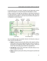

Advanced functionalities
4
Understanding aerial mapping with the
swinglet CAM
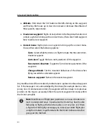
Goal of this section:
Aerial mapping using the
swinglet CAM
is de-
signed to be simple and fully automatic, requiring very little input
from the user. Understanding the basics of aerial navigation, how-
ever, can help you map more complex terrain and yield higher quality
results. This section explains the basics of waypoint-based navigation
and the control strategies used by the drone for flight.
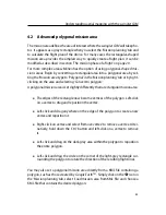
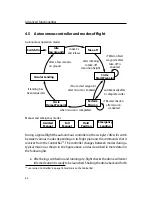
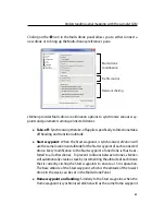
4.1
Waypoints and their properties
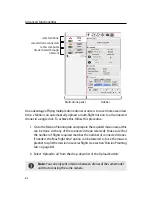
The
swinglet CAM
uses a flight plan consisting of a list of waypoints to navigate.
A waypoint essentially consists of a circle about a given position and information
that defines how the drone should behave when reaching them. The entire list
of waypoints is stored in the drone autopilot and can be remotely edited using
eMotion
.
from pr
evious
wa
ypoin
t
to next
waypoint
Position (GPS coordinates)
Altitude:
Above Take-off location (m/ATO)
OR
Above Mean Sea Level (m/AMSL)
Radius
Direction
In
eMotion
every waypoint is defined by the following parameters:
•
ID:
Every mission waypoint has a unique ID, beginning at 1. The
swinglet CAM
50
Содержание swinglet
Страница 1: ...Extended User Manual swinglet CAM Revision 12 September 2014 Copyright 2010 2014 senseFly Ltd...
Страница 13: ...6 5 Charging the remote control 112...
Страница 48: ......
Страница 49: ...Part II Advanced functionalities...
Страница 114: ......
Страница 115: ...Part III Maintenance Repair and Troubleshooting...
Страница 148: ......
Страница 149: ...Part IV Speci cations...
Страница 154: ......


