Lynx
®
NGT-9000
Pilot’s Guide
2-28
Operation
NEXRAD Map Elements
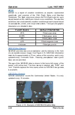
NEXRAD provides data on precipitation and its intensity in the form
of a composite mosaic image. See Figure 2-15. NEXRAD information
extends to approximately a 75 nm radius of the ownship, and is only
updated every 5 minutes. Note - Freezing precipitation colors (pink/
blue) are not provided.
The age of the NEXRAD data is shown in the lower left corner of the
screen with yellow text. The time stamp is labeled with “RDR” and
“min”. Dashes replace the time stamp when no NEXRAD image data
is available.
CONUS Map Elements
CONUS information covers the Continental United States. It is only
updated every 15 minutes.
FliGht ruleS
diSPlay ProPertieS
VFR
Filled cyan circle
MVFR
Filled green circle
IFR
Filled yellow circle
LIFR
Filled magenta circle
Unknown
Filled grey circle
Figure 2-15: Example of NEXRAD Weather Map
METAR
METAR is a report of weather conditions at airports represented
graphically and consists of the FAA Flight Rules and Weather
Conditions. The flight rules icons shows the FAA flight rules for each
airport based on the visibility and cloud cover conditions. The weather
conditions icons indicates the weather conditions at each airport based
on precipitation, winds, and visual obstructions. The type and graphic
description are detailed below:
Содержание Lynx NGT-9000+
Страница 26: ...Lynx NGT 9000 Pilot s Guide 1 16 Description Page intentionally blank...
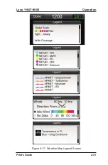
Страница 57: ...Lynx NGT 9000 Pilot s Guide 2 31 Operation Figure 2 17 Weather Map Legend Screen...
Страница 68: ...Lynx NGT 9000 Pilot s Guide 2 42 Operation Page intentionally blank...
Страница 82: ...Lynx NGT 9000 Pilot s Guide 4 6 Troubleshooting Page intentionally blank...
Страница 96: ...0040 17000 01 Revision E July 24 2015 Aviation Products...


