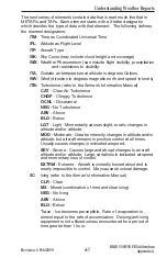


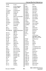

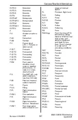
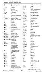
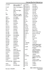
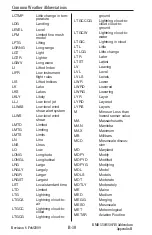
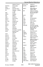
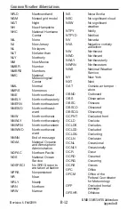

Revision 6 Feb/2009
A-13
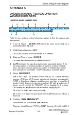
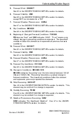
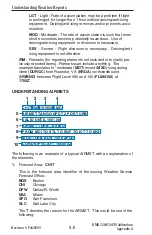
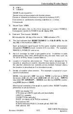
2.
Report Type:
WST
WST
indicates this is a convective SIGMET.
3.
Date and Time Issued:
221855
.
22
indicates the 22nd day of the month.
1855
indicates UTC.
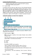
4.
This line is the identifying number of the Convective SIGMET.
Numbering begins daily at 0000 UTC. The
C
denotes the Central
portion of the country.
5.
This line indicates that
CONVECTIVE SIGMET 20C
is
VALID
UNTIL 2055Z
time. Expiration time is two hours after issuance, but
Convective SIGMETs are issued hourly and replace the previous
hour’s product.
Each subsequent report issued for this same weather phenomenon
would increment the number. For example, 21C, 22C and so on.
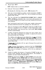
6
.
Area of coverage by state
ND
(North Dakota) and
SD
(South
Dakota) or geographic area. In addition to state abbreviations, other
area abbreviations may be seen here, such as
FL CSTL WTRS
(Florida Coastal Waters).
7
.
Location of weather phenomenon (may be an area, single cell or
line). Three letter designators for navaids or airports are used to
describe boundaries of coverage.
The starting and ending point are identical for an area of thunder-
storms, like this:
FROM 90W MOT-GFK-ABR-90W MOT
(from 90
nm west of Minot, ND to Grand Forks, ND to Aberdeen, SD to 90 nm
west of Minot, ND).
A Single Cell thunderstorm 35 nm west of Kansas City would look
like this:
35WMKC
A Line of severe thunderstorms would look like this:
FROM 90SE
SGF-70NE TXK-50NE LFK
(from 90 nm southeast of Springfield,
MO to 70 nm northeast of Texarkana, AR to 50 nm northeast of
Lufkin, TX).
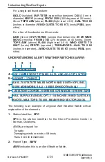
8
.
Details of weather phenomenon. Convective SIGMET details are
mostly in plain language with some abbreviations. This example is
typical for an area of severe thunderstorms:
INTSFYG
(intensifying)
AREA
(of)
SVR TSTMS
(severe thunder-
storms)
MOVG
(moving)
FROM 2445
(240 degrees at 45 knots).
Storm
TOPS ABV
(above)
FL450
(flight level 4-5-0).
WIND GUSTS
TO 60KT
(knots)
RPRTD
(reported).
TORNADOES…HAIL TO 2 IN
(inches in diameter)
…WIND GUSTS TO 65 KT
(knots)
PSBL
(pos-
sible) in the
ND PTN
(North Dakota portion).
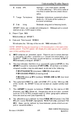
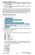
KMD 550/850 FIS Addendum
Appendix A
Understanding Weather Reports
Содержание Bendix/King KMD 550
Страница 13: ...iv Revision 6 Feb 2009 KMD 550 850 FIS Addendum Table of Contents Intentionally left blank ...
Страница 113: ...A 16 Revision 6 Feb 2009 KMD 550 850 FIS Addendum Appendix A Understanding Weather Reports Intentionally left blank ...
Страница 135: ...B 22 Revision 6 Feb 2009 Common Weather Abbreviations KMD 550 850 FIS Addendum Appendix B Intentionally left blank ...