Garmin GPSMAP 400 series Скачать руководство пользователя страница 21

400/500 Series Display Interfaces

4-1

SECTION 4

RYAN TCAD INTERFACE

SECTION 4  RYAN TCAD INTERFACE

Differences between the Ryan 9900B TCAD and 
the Ryan 9900BX TCAD

All information in this section pertaining to the display 

and control of the Ryan 9900B TCAD also applies to the 
Ryan 9900BX TCAD except for the following:

•  TCAS-like symbology is used in the 9900BX as 

opposed to the 9900B (similar to SKYWATCH).

•  Altitude modes are available similar to 

SKYWATCH (normal, look up, look down, 
unrestricted).

•  Ranges are manually controlled instead of being 

automatically re-sized to the current shield.

•  Traffic display range selections are different:
•  Ryan 9900B—range is slaved to current shield 

size.

•  Ryan 9900BX—2 nm, 2 and 6 nm, 6 and 12 nm, 

12 and 24 nm.

Ryan TCAD Description


NOTE:  

Refer to the Ryan TCAD Pilot’s Guide for a 

detailed description of the Ryan TCAD System.

The Ryan TCAD (Traffic and Collision Alert Device) is 

an on-board air traffic display used to identify potential 
collision  threats.    TCAD  computes  relative  altitude 
and  range  of  threats  from  nearby  Mode  C  and  Mode  
S-equipped aircraft.  TCAD will not detect aircraft without 
operating  transponders  or  those  that  are  beyond  radar 
coverage.  TCAD, within defined limits, creates a shield 
of  airspace  around  the  aircraft,  whereby  detected  traffic 
cannot penetrate without triggering an alert.

Operator Controls and Basic Displays

If there is no communication between the display unit 

and the TCAD unit, a message will appear, notifying the 
user.  After initialization, proceed with operation of the 
400/500 Series unit in a normal manner.

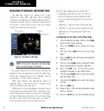
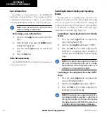
TCAD data can be shown in a “thumbnail” view on the 

Map Page.  TCAD data also displays on both the Traffic 
Page  (Figure  4-1)  and  the  Map  Page  if  heading  data  is 
available.

Figure 4-1  Traffic Page

The symbols for closing and parting traffic shown on 

both the Map Page and the Traffic Page are identical to 
those shown on the Ryan TCAD (see Ryan TCAD Pilot’s 
Guide for detailed decscription):

Symbol Name

Description

TRFC

Altitude separation >500 feet, steady 
altitude separation

TA

Altitude separation <=500 feet, 
steady altitude separation

TRFC

Altitude separation >500 feet, closing

PA

Altitude separation <=500 feet, 
parting

TRFC

Altitude separation >500 feet, parting

TA

Altitude separation <=500 feet, 
closing

Table 4-1

190-00140-10  Rev. E

Содержание GPSMAP 400 series

Страница 1: ...dum Goodrich STORMSCOPE WX 500 Series II Weather Mapping Sensor Goodrich SKYWATCH Traf c Advisory System Model SKY497 Goodrich SKYWATCH HP Traf c Advisory System Model SKY899 Bendix King KTA870 TAS KM...

Страница 2: ......

Страница 3: ...or written consent of Garmin Garmin hereby grants permission to download a single copy of this manual and of any revision to this manual onto a hard drive or other electronic storage medium to be view...

Страница 4: ...educe the risk of unsafe operation thoroughly practice basic operation prior to actual use When in actual use carefully compare indications from the Garmin Series Unit with all available navigation so...

Страница 5: ...etween Standby and Operating Modes 3 2 Altitude Display Mode 3 3 Traf c Page 3 3 Traf c Warning Window 3 3 Traf c Page Display Range 3 4 Con guring Traf c Data on the Map Page 3 4 Highlighting Traf c...

Страница 6: ...400 500 Series Display Interfaces iv TABLE OF CONTENTS 190 00140 10 Rev E...

Страница 7: ...MSCOPE WX 500 Series II Weather Mapping Sensor Goodrich SKYWATCH Traf c Advisory System Model SKY497 Goodrich SKYWATCH HP Traf c Advisory System Model SKY899 Bendix King KTA870 TAS KMH880 Multi Hazard...

Страница 8: ...400 500 Series Display Interfaces 1 2 SECTION 1 INTRODUCTION Blank Page 190 00140 10 Rev E...

Страница 9: ...he display Interfaces are currently only available for the WX 500 Series II STORMSCOPE System Power Up Self Test The power up self test Figure 2 1 ensures that the WX 500 functions are operating prope...

Страница 10: ...useful during periods of heavy storm activity Displaying cell data during these periods frees the user from sifting through a screen full of discharge points and helps to better determine where the s...

Страница 11: ...d on the 2000 nm zoom scale butthedataonlygoesoutasfarastheSTORMSCOPE can report 200 nm North Up Mode Since the range for Stormscope data is 400 nm diameter total 200 nm in front and 200 nm behind the...

Страница 12: ...ot of conditions Selecting the panning function and panning the map display 1 Press the small right knob to activate the panning target pointer Figure 2 6 2 Turn the small right knob clockwise to move...

Страница 13: ...isplays either a 360 or a 120 viewing angle In normal operation the current strike rate is displayed in the top right hand corner and LTNG is displayed in the top left hand corner When in strike mode...

Страница 14: ...Display Interpretation For weather display interpretation study the examples in the WX 500 User s Guide which are designed to help relate the cell or strike patterns shown on the display to the size a...

Страница 15: ...and the aircraft both has a squat switch and is on the ground the Standby Screen is displayed Figure 3 1 If the SKYWATCH passes the power up test and the aircraft both has a squat switch and is airbor...

Страница 16: ...irspace around the airport before takeoff Operating Mode is con rmed by the display of OPER in the upper right hand corner of the Traf c Page Figure 3 2 Switching to Operating Mode from Standby Mode 1...

Страница 17: ...altitude display ranges NOTE Con rmation is not required the mode is changed immediately when using the small right knob Figure 3 2 UNR Selected 3 Press the small right knob to turn the cursor off aft...

Страница 18: ...s for details Con guring traf c on the Map Page 1 Turn the small right knob to select the Map Page 2 Press the MENU Key to display the Page Menu 3 Turn the small right knob to select Setup Map 4 Press...

Страница 19: ...he top three data elds top four elds on the 500 Series on the right side of the Map Page Figure 3 8 When a Traf c Advisory is active the Traf c banner is displayed in the lower right corner of the Map...

Страница 20: ...t knob clockwise to move up or counterclockwise to move down 3 Turn the large right knob clockwise to move right or counterclockwise to move left 4 To cancel the panning function and return to the pre...

Страница 21: ...y Mode C and Mode S equipped aircraft TCAD will not detect aircraft without operating transponders or those that are beyond radar coverage TCAD within de ned limits creates a shield of airspace around...

Страница 22: ...tion 9 Turn the small right knob to select the desired option 10 Press the ENT Key Repeat steps 8 10 forTraf c Symbol and Traf c Label 11 Press the CLR Key to return to the Map Page Displaying Thumbna...

Страница 23: ...the present position When the target pointer is placed on traf c the traf c range altitude separation squawk code if available and tail number if available are displayed Figure 4 4 Panning the map 1...

Страница 24: ...Press the ENT Key 7 Select the desired remaining options elds by turning the large right knob then turn the small right knob to select the desired option and press the ENT Key to con rm the selection...

Страница 25: ...t the barometric pressure in the Ryan TCAD unit Please refer to the TCAD Pilot s Handbook for a detailed description of this feature Changing the Barometric Pressure 1 From the Traf c Page press the s...

Страница 26: ...arning Window Threat Acquisition Refer to the TCAD Pilot s Handbook for a detailed description of the Air Shield Audible and Visible Alerts Voice and tones are used to alert the pilot The alert descri...

Страница 27: ......

Страница 28: ...U S A p 503 391 3411 f 503 364 2138 Garmin Europe Ltd Liberty House Bulls Copse Road Hounsdown Business Park Southampton SO40 9RB U K p 44 0 870 8501241 f 44 0 870 8501251 Garmin Corporation No 68 Ja...

Отзывы: