background image

9

Map Page

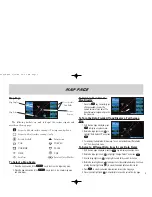
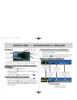
The following symbols are used to depict the various airports and

navaids on the map page:

Airport with hard surface runway(s); Primary runway shown

Airport with soft surface runway(s) only

Private Airfield

Intersection

VOR

VORTAC

VOR/DME

TACAN

DME

NDB

Localizer

Locator Outer Marker

To Select a Map Scale

1. Press the up arrow side of the 

R

key to zoom out to a larger map area.

2. Press the down arrow side of the 

R

key to zoom in to a smaller map area

and more detail.

To Quickly Declutter the

Map Display

1. Press the 

c

key momentarily (as

often as needed) to select the

desired amount of map detail. The

declutter level will appear adjacent to

the map scale.

To Turn the Data Fields Off and Display a Full Screen

Map

1. With the map page displayed, press

m

to display an options menu.

2. Rotate the large right knob (

d

) to

highlight “Data Fields Off?” and press

E

.

3. To re-display the data fields, follow steps 1 and 2, but instead select “Data Fields

On?” from the options menu.

To Select a Different Data Item for any Data Field:

1. With the map page displayed, press the 

m

key to display an options menu.

2. Rotate the large right knob (

d

) to highlight “Change Fields?”, and press 

E

.

3. Use the large right knob (

d

) to highlight the data field you wish to change.

4. Rotate the small right knob (

a

) to display the list of available data items. Continue

rotating the small right knob (

a

) to select the desired data item from the list.

5. Press 

E

to select the desired data item and return to the map page.

6. Press the small right knob (

r

) momentarily to remove the cursor from the page.

MAP PAGE

User-selectable

Data Fields

Map Display

Present

Position

Map Scale

420QR.qxd  9/12/00  10:27 AM  Page 9

Содержание GNC 420

Страница 1: ...G N C 4 2 0 Q u i c k R e f e r e n c e 420QR qxd 9 12 00 10 27 AM Page 1...

Страница 2: ...ist The options list allows you to make settings changes which relate to the currently displayed page The clear key c is used to erase information or cancel an entry Press and hold this key to immedia...

Страница 3: ...cedures key P allows you to select approaches departures and arrivals from your active flight plan When using a flight plan available procedures for your departure and or arrival airport are offered a...

Страница 4: ...f and large h left knobs to select the desired frequen cy The COM W flip flop key is used to activate the selected frequency Frequency Selection 1 Rotate the large left knob h to select the desired me...

Страница 5: ...ght plan pages are selected by pressing the F key and using the small right knob a to select the desired page FPL Group Nearest Airport Nearest Intersection Nearest NDB Nearest VOR Nearest User Waypoi...

Страница 6: ...ate the large right knob d to highlight the facility name second line or the city third line field 3 Use the small a and large d right knobs to enter the facility name or city location of the desired...

Страница 7: ...ond line or the city third line field 4 Use the small a and large d right knobs to enter the facility name or city loca tion of the desired destination waypoint As you spell the facility name or city...

Страница 8: ...he default NAV page displayed press the m key to display an options menu 2 Rotate the large right knob d to highlight the Change Fields option and press E to select this option 3 Use the large right k...

Страница 9: ...e map page displayed press m to display an options menu 2 Rotate the large right knob d to highlight Data Fields Off and press E 3 To re display the data fields follow steps 1 and 2 but instead select...

Страница 10: ...ight hand side of the screen will indicate which part of the list is cur rently being displayed Auto Tuning a Frequency from the NAVCOM Page 1 Highlight the desired frequency by scrolling through the...

Страница 11: ...the selected airport 3 To view additional WPT pages for the selected airport including the airport runway and airport frequency pages press the small right knob r to remove the flashing cursor Rotate...

Страница 12: ...Plan and press E To Stop Navigating a Flight Plan 1 Press F 2 Press m to display the flight plan options 3 Rotate the large right knob d to highlight Delete Flight Plan and press E Press E again to co...

Страница 13: ...cat ing that GPS guidance on such approaches is strictly for monitoring only use the external navigation receivers and CDI or HSI for prima ry navigation To confirm this reminder highlight Yes and pre...

Страница 14: ...ch Due to the variety of available approach procedures the specific steps required will vary according to the approach selected Keep the following general guidelines in mind while flying the approach...

Страница 15: ...tomatic waypoint sequencing For course reversals way point sequencing is suspended for one trip around the holding pattern only after which it will return to automatic waypoint sequencing The CDI will...

Страница 16: ...Street Olathe KS 66062 GARMIN Europe LTD Unit 5 The Quadrangle Abbey Park Industrial Estate Romsey SO51 9AQ U K GARMIN Asia Corp No 68 Jangshu 2nd Road Shijr Taipei County Taiwan Website Address www g...

Отзывы: