background image

If you need to stop at additional destinations, you can add the 

locations to your route (

Adding a Location to Your Route

page 6

).

Starting a Route by Using the Map

You can start route by selecting a location from the map.

1

Select 

View Map

.

2

Drag and zoom the map to display the area to search.

3

If necessary, select   to filter the displayed points of interest 

by category.
Location markers (  or a blue dot) appear on the map.

4

Select an option:
• Select a location marker.
• Select a point, such as a street, intersection, or address 

location.

5

Select 

Go!

.

Going Home

The first time you start a route home, the device prompts you to 

enter your home location.

1

Select 

Where To?

 > 

Go Home

.

2

If necessary, enter your home location.

Editing Your Home Location

1

Select 

Where To?

 >   > 

Set Home Location

.

2

Enter your home location.

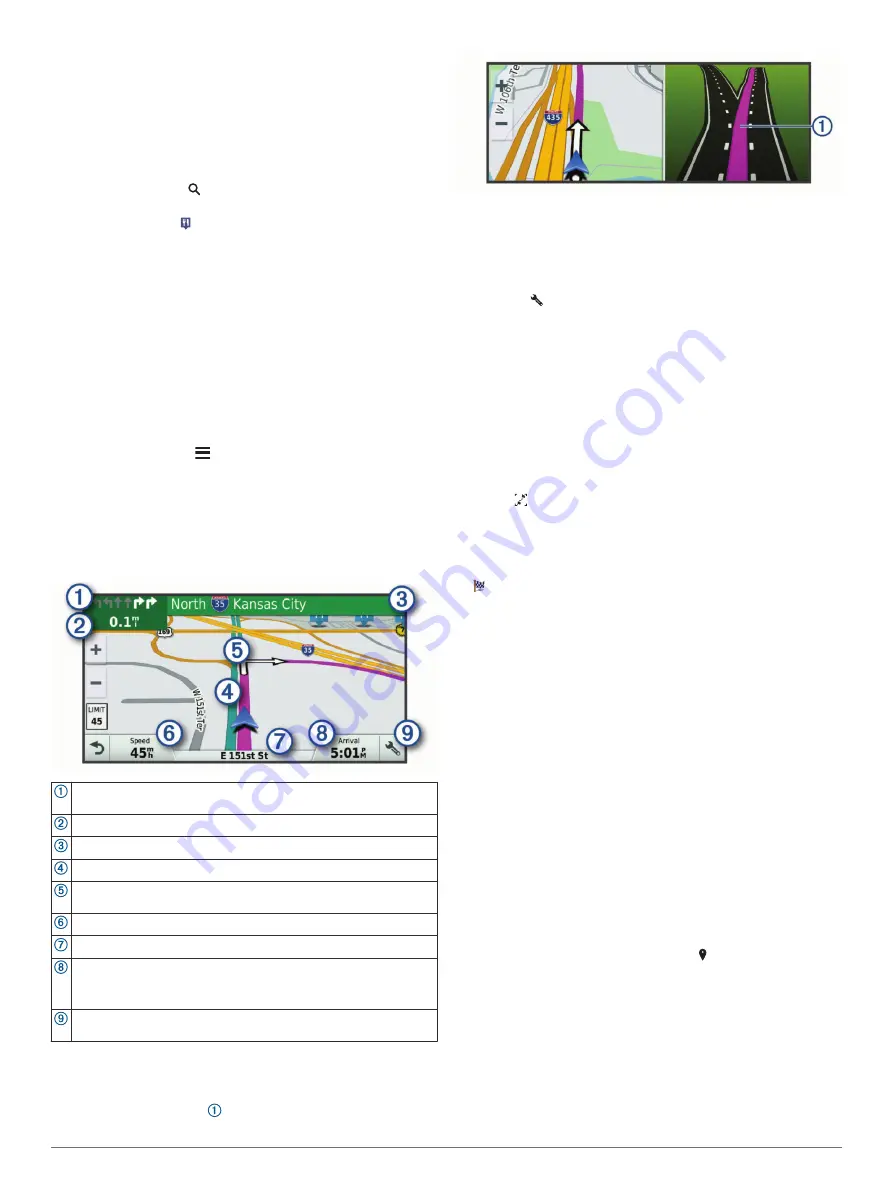
Your Route on the Map

As you travel, the device guides you to your destination using 

voice prompts and information on the map. Instructions for your 

next turn or exit, or other actions appear across the top of the 

map.

Next action in the route. Indicates the next turn, exit, or other action 
and the lane in which you should travel, if available.
Distance to the next action.

Name of the street or exit associated with the next action.

Route highlighted on the map.

Next action in the route. Arrows on the map indicate the location of 
upcoming actions.
Vehicle speed.

Name of the road on which you are traveling.

Estimated arrival time.

TIP: 

You can touch this field to change the information it shows 

(

Changing the Map Data Field

, page 11

).

Map tools. Provides tools to show you more information about your 
route and surroundings.

Active Lane Guidance

As you approach some turns, exits, or interchanges in your 

route, a detailed simulation of the road appears beside the map, 

if available. A colored line   indicates the proper lane for the 

turn.

Viewing Turns and Directions

While navigating a route, you can view upcoming turns, lane 

changes, or other directions for your route.

1

From the map, select an option:
• To view upcoming turns and directions as you navigate, 

select   > 

Turns

.

The map tool displays the next four turns or directions 

beside the map. The list updates automatically as you 

navigate the route.

• To view the complete list of turns and directions for the 

entire route, select the text bar at the top of the map.

2

Select a turn or direction (optional).
Detailed information appears. An image of the junction may 

appear for junctions on major roadways, if available.

Viewing the Entire Route on the Map

1

While navigating a route, select anywhere on the map.

2

Select  .

Arriving at Your Destination

When you approach your destination, the device provides 

information to help you complete your route.

 indicates the location of your destination on the map, and a 

voice prompt announces you are approaching your 

destination.

• When you approach some destinations, the device 

automatically prompts you to search for parking. You can 

select Yes to find nearby parking areas (

Parking Near Your 

Destination

, page 5

).

• When you stop at your destination, the device automatically 

ends the route. If the device does not detect your arrival 

automatically, you can select Stop to end your route.

Parking Near Your Destination

Your device can help you find a parking spot near your 

destination. When you approach some destinations, the device 

automatically prompts you to search for parking.

NOTE: 

This feature should be used only when you are using the 

car vehicle profile. While using a truck vehicle profile, you can 

search for truck parking near your destination (

Finding Truck 

Parking

, page 9

).

1

Select an option:
• When the device prompts you, select 

Yes

 to search for 

nearby parking.

• If the device does not prompt you, select 

Where To?

 > 

Categories

 > 

Parking

, and select   > 

My Destination

.

2

Select 

Filter Parking

, and select one or more categories to 

filter parking by availability, type, price, or payment methods 

(optional).

NOTE: 

Detailed parking data is not available in all areas or 

for all parking locations.

3

Select a parking location, and select 

Go!

 > 

Add As Next 

Stop

.

The device guides you to the parking area.

Navigating to Your Destination

5

Содержание FLEET 780

Страница 1: ...GARMINFLEET 780 790 Owner sManual...

Страница 2: ...t Garmin Express myTrends are trademarks of Garmin Ltd or its subsidiaries These trademarks may not be used without the express permission of Garmin The Bluetooth word mark and logos are owned by the...

Страница 3: ...egory 8 Location Search Results 8 Location Search Results on the Map 8 Changing the Search Area 8 Custom Points of Interest 8 Installing POI Loader 8 Finding Custom POIs 8 Parking 9 Finding Truck Park...

Страница 4: ...tion Volume 16 Setting the Text Language 16 Adding Accounts 16 Date and Time Settings 16 Device Settings 16 Restoring Settings 16 Resetting Data and Settings 17 Device Information 17 Viewing Regulator...

Страница 5: ...OTICE Both the device and its mount contain magnets Under certain circumstances magnets may cause damage to some electronic devices including hard drives in laptop computers Use caution when the devic...

Страница 6: ...e Calling page 12 Active vehicle profile Swipe down twice and select to view the vehicle profile settings Vehicle Profiles page 2 Battery charge level Adjusting the Screen Brightness You can adjust th...

Страница 7: ...op of the screen Select to save a dash cam recording Select to stop dash cam recording Select to start dash cam recording Select to enable audio recording Select to disable audio recording Dash Cam Re...

Страница 8: ...ou may be crossing a lane boundary unintentionally Enabling or Disabling Audible Driver Alerts You can enable or disable the audible tone for some types of driver alerts The visual alert appears even...

Страница 9: ...or your route 1 From the map select an option To view upcoming turns and directions as you navigate select Turns The map tool displays the next four turns or directions beside the map The list updates...

Страница 10: ...Tools page 10 2 Select an option To detour your route for a specific distance select Detour by Distance To detour around a specific road on the route select Detour by Road To find a new route select...

Страница 11: ...t deleting it 1 Select Navigation Route Preferences Custom Avoidances 2 Select an avoidance 3 Select Disable Deleting Custom Avoidances 1 Select Navigation Route Preferences Custom Avoidances 2 Select...

Страница 12: ...view more results Select a location to view the option menu Select to view detailed information about the selected location Select to find parking areas near the location Select to view alternate rout...

Страница 13: ...nding a Location Using Coordinates You can find a location using latitude and longitude coordinates This can be helpful when geocaching 1 Select Where To Categories Coordinates 2 If necessary select a...

Страница 14: ...r route Up Ahead Displays upcoming locations along the route or the road on which you are traveling Up Ahead page 10 Turns Displays a list of upcoming turns in your route Viewing Turns and Directions...

Страница 15: ...an accurately measure elapsed time during the trip From the map select Speed Viewing the Trip Log Your device keeps a trip log which is a record of the path you have traveled 1 Select Navigation Map V...

Страница 16: ...To mute the microphone select To hang up select Saving a Phone Number as a Preset You can save up to three contacts as presets on the dial pad This allows you to quickly call your home phone number fa...

Страница 17: ...To record the amount in gallons select Liters Gallons Save 6 If necessary select the Tax Included check box 7 Select Next 8 Select an option to record the fuel station where you refueled Select a near...

Страница 18: ...dded all the necessary locations select Next Save 8 Enter a name and select Done Editing and Reordering Locations in a Trip 1 Select Trip Planner Saved Trips 2 Select a saved trip 3 Select a location...

Страница 19: ...traffic details the device uses You can set your device to avoid traffic when calculating routes and to find a new route to your destination if a traffic delay occurs Avoiding Traffic Delays on Your...

Страница 20: ...you to set the amount of idle time before your device enters sleep mode while using battery power Daydream Enables or disables the daydream screen saver Font size Increases or decreases the font size...

Страница 21: ...cannot download map and software updates using a mobile data connection Garmin fleet 790 Mobile Data Modes Region Supported Modes United States 3G B2 1900 B5 850 LTE B2 1900 B4 1700 B5 850 B12 700 B1...

Страница 22: ...is assembled correctly If your device does not charge in your vehicle you may need to replace the fuse located at the tip of the vehicle adapter 1 Rotate the end piece counter clockwise to unlock it T...

Страница 23: ...se the storage space for maps and other data on your device You can purchase memory cards from an electronics supplier or go to www garmin com maps to purchase a memory card with pre loaded Garmin map...

Страница 24: ...nd reports 13 fuel data 13 jurisdiction summary 13 trip reports 13 intersections finding 9 J jurisdiction summary 13 L lane departure warning system LDWS 4 language 16 latitude and longitude 9 locatio...

Страница 25: ...ory 16 trip information 11 resetting 11 viewing 11 trip log viewing 11 trip planner 14 editing a trip 14 shaping points 14 troubleshooting 18 19 truck map 13 points of interest 7 profiles 2 3 trailer...

Страница 26: ...support garmin com GUID 9BA4E0BC 60EC 4046 814E DC9F864FE0B6 v4 March 2020...

Отзывы: