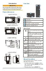


Introduction
1
Introduction ..................................................4
Device Keys ..................................................................................... 4
Manual Conventions ........................................................4
Getting More Information .................................................5
Inserting Memory Cards...................................................5
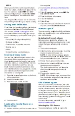
Loading the New Software on a Memory Card ...............5
Software Update ..............................................................5
Updating the Device Software ......................................................... 5
GPS Satellite Signals .......................................................5
Selecting the GPS Source ............................................................... 5
Charts and 3D Chart Views .........................6
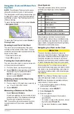
Navigation Chart and Offshore Fishing Chart ..................7
Zooming In and Out of the Chart ..................................................... 7
Panning the Chart with the Keys ..................................................... 7
Selecting an Item on the Map Using the Device Keys .................... 7
Measuring a Distance on the Chart ................................................. 7
Chart Symbols .................................................................................. 7
Navigating to a Point on the Chart ................................................... 7
Viewing Location and Object Information on a Chart ...................... 8
Viewing Details about Navaids ........................................................ 8
Heading Line and Angle Markers .................................................... 8
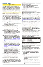
Premium Charts ...............................................................9
Viewing Tide Station Information ..................................................... 9
Showing Satellite Imagery on the Navigation Chart ......................10
Viewing Aerial Photos of Landmarks .............................................10
Garmin Quickdraw™ Contours Mapping .......................10
Mapping a Body of Water Using the Garmin Quickdraw Contours
Feature ...........................................................................................10
Adding a Label to a Garmin Quickdraw Contours Map .................10
Garmin Quickdraw Contours Settings ........................................... 11
Automatic Identification System
..................................... 11
AIS Targeting Symbols ................................................................... 11
Heading and Projected Course of Activated AIS Targets ..............12
Showing AIS Vessels on a Chart or 3D Chart View .....................12
Activating a Target for an AIS Vessel .............................................12
Viewing a List of AIS Threats .........................................................12
Setting the Safe-Zone Collision Alarm ...........................................12
AIS Distress Signals.......................................................................13
Turning Off AIS Reception .............................................................13
Chart and 3D Chart View Settings .................................13
Overlay Numbers Settings .............................................................14
Showing a Navigation Inset ...........................................................15
Chart Appearance Settings ............................................................15
Setting the Heading and Course Over Ground Lines....................15
Other Vessels Settings on the Charts and Chart Views ................16
Fish Eye 3D Settings .....................................................................16
Navigation with a Chartplotter ..................16
Searching for a Destination by Name ............................................17
Selecting a Destination Using the Navigation Chart......................18
Searching for Destination Using User Data ...................................18
Searching for a Marine Services Destination ................................18
Courses ..........................................................................18
Setting and Following a Direct Course Using Go To .....................19
Marking Your Present Location as a Waypoint ..............................19
Creating a Waypoint at a Different Location ..................................19
Marking an MOB or SOS Location ................................................19
Viewing a List of all Waypoints.......................................................19
Editing a Saved Waypoint ..............................................................19
Browsing for and Navigating to a Saved Waypoint .......................19
Deleting a Waypoint or an MOB ....................................................20
Deleting All Waypoints ...................................................................20
Routes ............................................................................20
Creating and Navigating a Route From Your Present Location ....20
Creating and Saving a Route .........................................................20
Viewing a List of Routes ................................................................20
Editing a Saved Route ...................................................................20
Browsing for and Navigating a Saved Route .................................20
Browsing for and Navigating Parallel to a Saved Route ...............21
Deleting a Saved Route .................................................................21
Deleting All Saved Routes .............................................................21
Tracks .............................................................................21
Showing Tracks ..............................................................................21
Setting the Color of the Active Track ..............................................21
Saving the Active Track ..................................................................21
Viewing a List of Saved Tracks ......................................................22
Editing a Saved Track ....................................................................22
Saving a Track as a Route .............................................................22
Browsing for and Navigating a Recorded Track ............................22
Deleting a Saved Track ..................................................................22
Deleting All Saved Tracks ..............................................................22
Retracing the Active Track .............................................................22
Clearing the Active Track ...............................................................22
Managing the Track Log Memory During Recording ....................22
Table of Contents