


44
Introduction
often this is found near the map key.
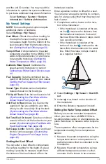
2
On the chartplotter, select Settings
>Units.
3
Select the correct map datum and posi-
tion format settings.
4
Create the waypoint again.
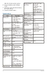
Specifications
Item
Parameter
Display size
9’ diag (95sv)
7’ diag (75dv/75sv)
5’ diag (55dv)
4.3’ diag (45dv)
Display resolution 800 x 480 (95sv/75d-
v/75sv)
480 x 480 (55dv)
272 x 480 (45dv)
Power supply
10-20 V
Power consumption
12V
11W (95sv) /
6.2W/7.1W (75dv/75sv)
7.1W (55dv) / 5W
(45dv)
GPS receiver
5 Hz GPS/GLONASS,
internal
Worldwide base-
map preload
Yes
Number of way-
points
5,000
Number of routes
100
Number of track
50 saved tracks (
50,000 Active Track
point)
Dual freuency so-
nar (50/200kHz)
YES
Dual beam sonar
(77/200kHz)
YES
Frequencies sup-
ported
CHIRP (low, medium,
high)
Traditional:
50/77/200 kHz
DownVü: 260/455/800
kHz
SideVü: 260/455/800
kHz (95sv/75sv only)
Transmit power
Up to 500 W (RMS)
Maximum depth
(@77kHz)
2,300 ft @ 77 kHz,
freshwater
1,100 ft @ 77 kHz,
saltwater
(depth capacity is
dependent on water
bottom type and other
water conditions)
Bottom lock
Yes
Water tempera-
ture recording and
graph
Yes
Sonar Recording
Yes
Sonar history
rewind
Yes
Transducer Inter-
face Type
45 dv:4 Pin
55 dv:4 Pin
7x dv/sv:8 Pin/12 Pin
9x sv:12 Pin
Marine Network
Interface
(Panoptix Sonar
interface)
75 dv/sv and 95 sv
support only
NMEA 0183 Input
Interface
1
NMEA 0183 Output
Interface
1
Waterproof accord-
ing to standard
IPX 7